|
|
Joined: Feb 2009
Posts: 383
Member
|
|
Member
Joined: Feb 2009
Posts: 383 |
Special? You betcha!
*"Special" note to Markskor (the only person who does not seem to know who Ridgeline is): He (Ridgeline) would be the last person on this board to do anything that would harm a bear, etc. That is why he would make a remark as he did, and it would be funny.
The body betrays and the weather conspires, hopefully, not on the same day.
|
|
|
|
|
Joined: Jun 2003
Posts: 160
Member
|
|
Member
Joined: Jun 2003
Posts: 160 |
Sorry, Did not realize that this was an "in" joke here.
Seen this same remark too often - for real.
Again, sorry.
mountain man who swims with trout
|
|
|
|
|
Joined: Feb 2009
Posts: 383
Member
|
|
Member
Joined: Feb 2009
Posts: 383 |
I hear you, and I probably would not have "said" anything if not for the "lazy" comment. It was too much of an incongruence to have "lazy" tagged with Ridgeline.
Too many generations of "educating" bears ala carelessness has defintely placed the old methods of food cache obsolete.
The body betrays and the weather conspires, hopefully, not on the same day.
|
|
|
|
|
Joined: Aug 2009
Posts: 125
Member
|
|
Member
Joined: Aug 2009
Posts: 125 |
Actually I got lazy and bought a Garcia when they were still selling prototypes. Much easier than doing a proper hang. (I never lost food with a hang and even have had bears look at the hang and walk on.)
Those pesky bears are figuring out that if a canister is chucked off a ledge it just might pop open when it hits bottom. We may have to go back to hanging and I'm sure they've forgotten how to crack a proper hang.
Last edited by Mike Condron; 06/24/14 12:19 AM. Reason: 've
Mike
|
|
|
|
|
Joined: Sep 2006
Posts: 444
Member
|
|
Member
Joined: Sep 2006
Posts: 444 |
Does anybody have experience with / evaluation of the Garmin GPSMAP 62stc GPS. It's on sale for $300 at REI. I've never used and never wanted a GPS, I'm an old-fashioned map and compass guy. But if I'm going to be backpacking I think it might be a good idea to have one (and learn how to use it).
|
|
|
|
|
Joined: Nov 2012
Posts: 55
Member
|
|
Member
Joined: Nov 2012
Posts: 55 |
Does anybody have experience with / evaluation of the Garmin GPSMAP 62stc GPS. It's on sale for $300 at REI. I've never used and never wanted a GPS, I'm an old-fashioned map and compass guy. But if I'm going to be backpacking I think it might be a good idea to have one (and learn how to use it). Hi Burt, I purchased this same unit ~ 6 months ago (also on sale) and offer the following (with the caveat that I have not really spent too much time with either the unit or the computer software - so my impressions may not be totally fair): Hardware is very good. - Powers on quickly - Acquires signal quickly - Rugged unit - so a bit heavy - accuracy seems excellent Hardware not so good: - Cannot recharge batteries without removing from unit Software I am not so fond of - User interface is "Old style". Not very intuitive. Menu is overly complex (IMO) - Must change pages to save trip - Unit continues on "current" trip after saving, so start of next trip is where unit left off from previous trip. This means you must remember to clear the current trip prior to starting new trip (and you must change pages to do this). Even then, there seems to be a separate memory for last point, so your new trip may start from end of previous trip. Bit of a nuisance. - The software for you computer (BaseCamp) is not much better in terms of being intuitive. To get most needed functionality you need to create an "Adventure". Again, my assessment may not be totally fair, based on limited use. I'm not sure I would purchase again. I also have an older Garmin Edge 705 (for use with bicycle that I have taken on hikes). It's software is much better and operation much more intuitive (however, it does not produce a .gpx file, and you must convert the .tcx file to .gpx, and I have not had good results with that). The 62stc is an even older generation which I think accounts for the older style user interface. Hope this helps. Regards, John
Last edited by John Sims; 06/25/14 07:54 PM.
|
|
|
|
|
Joined: Sep 2006
Posts: 444
Member
|
|
Member
Joined: Sep 2006
Posts: 444 |
John,
That is very helpful, exactly the kind of detailed evaluation I was looking for. Thanks.
|
|
|
|
|
Joined: Sep 2006
Posts: 444
Member
|
|
Member
Joined: Sep 2006
Posts: 444 |
What about the Garmin eTrex 30 Topo GPS Bundle, which costs $70 more.
Or, to approach the question from another direction: What GPS unit would people recommend for someone who doesn't want to spend much time learning how to use it and little time actually using it in the field? I'm not looking at this as a toy to have fun with. More like a piece of equipment, like my PLB, which I would carry as a safety measure.
I have done a fair amount of off-trail hiking in the past, using map and compass, and I'm still here to write about it. I have also made some dumb mistakes in my map reading, none of which put me in a bad place, but that doesn't mean the next mistake might not be more serious.
|
|
|
|
|
Joined: Aug 2011
Posts: 245
Member
|
|
Member
Joined: Aug 2011
Posts: 245 |
With Garmin units in general, I've found it a bit tricky to map out your route on a computer then convert the file over to something you can use on your GPS. I wrote a blog entry on this topic a while back, but I need to edit it and add more info. If you purchase maps for Basecamp, you map be able to create the maps there. I assume the need little processing to be used with Garmin products.
If your main purpose for the GPS is to use it to pinpoint your location, it may be easier.
The model I have is Garmin Refurbished Dakota 20 2.6" Handheld GPS. I got it on Walmart.com for $160 a couple of years ago.
|
|
|
|
|
Joined: Sep 2006
Posts: 444
Member
|
|
Member
Joined: Sep 2006
Posts: 444 |
That is my main and only purpose in getting a GPS. I looked at a couple evaluations of the Dakota 20 and I think your recommendation is right on the money. The Oregon 600 is nice but more than I need in functionality and more than I want to spend.
|
|
|
|
|
Joined: Nov 2012
Posts: 55
Member
|
|
Member
Joined: Nov 2012
Posts: 55 |
That is my main and only purpose in getting a GPS. I looked at a couple evaluations of the Dakota 20 and I think your recommendation is right on the money. The Oregon 600 is nice but more than I need in functionality and more than I want to spend. Hi Burt, If you use either an iPhone or Android you could really just download a navigation app and not get a dedicated GPS at all. I personally think today's smartphones are reliable and effective navigation tools. Typical cost of an app is less than $5.00, and you may also need a map (many apps come with free basic maps). I think this would be the least expensive route, with little if any compromise. The application "ViewRanger" comes with basic maps, is free, and has a web site where you can organize your hikes. You can also download maps to your iPhone/Android for use when "off the grid". This app works very well, and is used by many S&R organizations. http://www.viewranger.com/en-usJust another option. John
Last edited by John Sims; 06/26/14 01:10 AM. Reason: correct spelling
|
|
|
|
|
Joined: Apr 2010
Posts: 708
Member
|
|
Member
Joined: Apr 2010
Posts: 708 |
I have an earlier GPSMAP series GPS (Garmin 60csx, which was the industry standard for many years). Outstanding product. I took a 90 minute evening REI class to learn how to use it, and then it was pretty easy to use. I prefer the interface on the GPSMAP series to the old etrex, which is my only point of comparison.
I no longer carry it much. It is too heavy. If I am on a trail, I use a paper topo and a lightweight altimeter instead (sometimes aided by a compass). If you are on a trail, an altimeter makes it super easy to pinpoint your exact location on a topo map.
I also have an app for my Iphone -- MotionX GPS -- which was pretty cheap, and allows unlimited downloads (for free) of topo. The topo works all over the world -- indeed, in Nepal, the MotionX topo was more accurate than Nat Geos. Every once in a while, though, the map will delete itself (has happened twice in maybe 2 years). Definitely good as a supplemental aid -- but not something to rely upon.
I also have a variety of GPS-enabled topo for my Iphone, produced by Tom Harrison, and Nat Geo, for the major national parks in the US, plus the entire JMT. They correspondence perfectly with paper topo, so also good for pinpointing your location, subject to the caveat above. Though unlike the MotionX, these apps have never failed me, self-erased, or done anything else bad. So far.
In short, lots of reasons not to carry a dedicated GPS while backpacking. However, I still do use my Garmin 60csx when snowshoing, where trail finding can be tough, and it is nice to have a little aid...
|
|
|
|
|
Joined: May 2009
Posts: 117
Member
|
|
Member
Joined: May 2009
Posts: 117 |
Garmin GPS Map 62s - 9.2 ounces,
Topo map < 0.25 ounces
|
|
|
|
|
Joined: Aug 2011
Posts: 245
Member
|
|
Member
Joined: Aug 2011
Posts: 245 |
My Android phone worked great for my purposes. I personally haven't had much luck using my iPhone as a GPS, but I use it a bit differently than what you're planning. I like use my GPS to track my hikes and create GPX files, so it is always on. I've used this info to do things like create a detailed map of Skyline Trail: 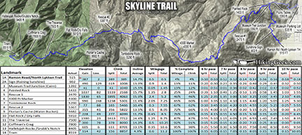 Some of the guys that I hike with have tried to use their iPhones to track their hikes and the batteries die quickly. If you would be just using it sporadically to confirm your position using an iPhone (assuming that's what you have), might be the solution for you. If you have an iPhone, you may do some research on this: http://bad-elf.com/pages/products.I just heard about this product yesterday and it looks neat. If I need to replace my Garmin or sell it at some point, I may look into it myself. If you're in the Riverside area some point before you decide what you're going to do and want to take a look at the Dakota 20, let me know. We could try to meet up.
|
|
|
|
|
Joined: Sep 2006
Posts: 444
Member
|
|
Member
Joined: Sep 2006
Posts: 444 |
Thanks, everyone, for the ideas. I am installing Viewranger on my Galaxy Note 3 Android phone, which has a big, clear screen. It's a much simpler and cheaper choice than any dedicated GPS unit and I think it will answer my need for a backup to map and compass.
|
|
|
|
|
Joined: Nov 2012
Posts: 55
Member
|
|
Member
Joined: Nov 2012
Posts: 55 |
Thanks, everyone, for the ideas. I am installing Viewranger on my Galaxy Note 3 Android phone, which has a big, clear screen. It's a much simpler and cheaper choice than any dedicated GPS unit and I think it will answer my need for a backup to map and compass. HiBurt, Most excellent. I think (over time, as you learn how the app and web page work) you will reverse primary and backup roles. Regards, John
|
|
|
|
|
Joined: Aug 2011
Posts: 245
Member
|
|
Member
Joined: Aug 2011
Posts: 245 |
Thanks, everyone, for the ideas. I am installing Viewranger on my Galaxy Note 3 Android phone, which has a big, clear screen. It's a much simpler and cheaper choice than any dedicated GPS unit and I think it will answer my need for a backup to map and compass. If I had the Note 3 available to me, I'd do the same!  To conserve battery life, you should be able to put your phone in airplane mode, then turn on the GPS.
|
|
|
|
|
Joined: Apr 2010
Posts: 708
Member
|
|
Member
Joined: Apr 2010
Posts: 708 |
On my iPhone, GPS does not work in airplane mode. I just use my iPhone to check coordinates -- not to track -- so I keep it either off or in airplane mode until I need a reading. Battery usage is minimal.
|
|
|
|
|
Joined: Aug 2011
Posts: 245
Member
|
|
Member
Joined: Aug 2011
Posts: 245 |
burtw, I have a new Six Moon Designs Lunar-Duo tent. Since buying the Lunar-Duo, someone gave me a free tent. It's marginally heavier than the LunarDuo Outfitter, so I am thinking about selling the LunarDuo and putting the money towards other gear. PM if you are interested: http://www.sixmoondesigns.com/tents/outfitter.html
|
|
|
|
|
Joined: Apr 2014
Posts: 4
Member
|
|
Member
Joined: Apr 2014
Posts: 4 |
Hi 63C, I'm picking up an REI Quarter Dome 1 tent tomorrow. At 34 ounce plus a little extra for a footprint it's plenty light if not ultra light.
I plan to do a short car camping trip this Monday and Tuesday to try out the tent and some other new gear. The following week I expect to do an easy 4 day backpack.
If that goes well I'll have some gear to sell, too, stuff that's fine for car camping but not backpacking.
|
|
|
|
|


