If you read my long TR about my hike up and down the MWMT on 6/24 you will see that I have to give up on doing the MWMT anymore but I am still interested in high Sierra walk-ups. I had planned on doing Langley next week but now I have some questions:
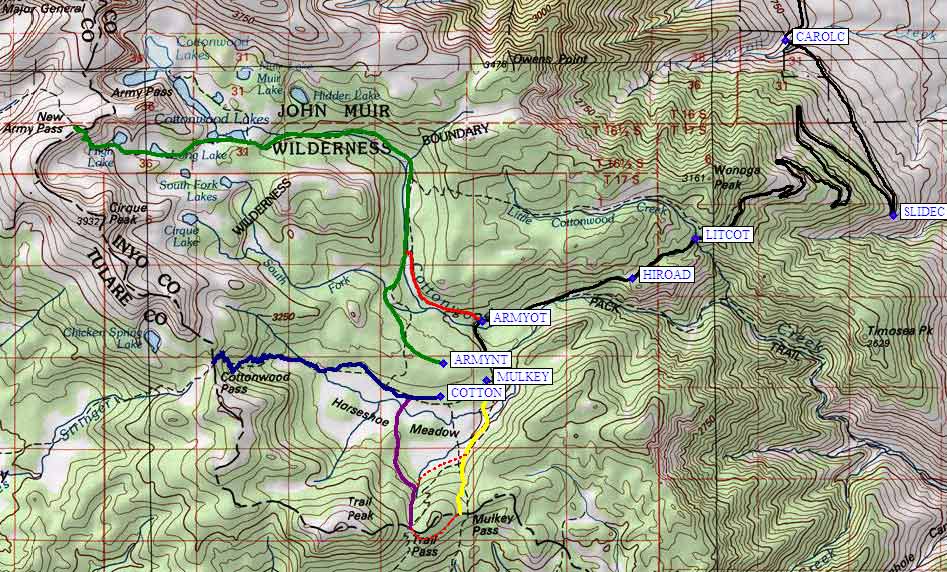
I know that (o)AP isn't maintained anymore but am I right that it is in pretty good condition? And is Langley via (o) Army Pass about 17.5 miles rt from Horseshoe Meadows? I have hiked to Long Lake then over to the Cottonwood Lakes and back to the campground and it looks like almost all the 4,100' elevation gain up Langley is packed into the last few miles from the bottom of the pass to the summit.
Can always boost your mojo on White Mountain if what you want is another 14er!!!
Langley is fun and a beautiful hike. If you do cottonwood lakes TH, there is little gain for the first six or so miles that get you to cottonwood lakes. The big gain is on the climb to the pass (whether AP or NAP) and then after you cross the plateau above the passes, from the plateau to the summit (though you are also gaining altitude on the plateau itself as you move from AP to Langley). Most of the hike above the passes is well-defined use trail, though there is a steep sandy section followed by a short rock scramble right before you hit the summit plateau.
You might consider doing Cirque Peak, see how that goes, then try for Langley on a later trip. Would get you views and a sense of the lay of the land.
I scoped out the top of AP but ultimately did not take it, so I will leave that question for others. There was rockfall and so at least a brief scramble with some exposure (this is near where a solo hiker apparently fell to his death last year). Based on what I have heard so far, there may still be snow and/or ice, though at least 2 fresh trip reports are coming soon...
Thanks Akichow. I've been interested in Cirque Peak, too. When I was at High Lake last year I looked up and figured the view from the top must be great. What you said about AP gives me reason to pause - I usually hike alone and I have a low tolerance for risk when I'm by myself.
I have done White Mtn. twice, once from the gate and once when the lab had open house. It's a nice hike but I don't think it's worth a 3rd time.
Hello Burt, Congrats on you Whitney Summit...good job. Re Langley, did it last fall..found it to be easier by quite a bit than Whitney. Very straight forward going up AP, just a small work around over some large boulders on the trail near the top. I had read that the sand/scree from the top of AP to the cliffs was lousy, but I didn't find that to be the case. I had a group of young guys (like Shin I'm 64) in front of me that showed the way up the cliffs. Got a little sidetracked coming back down as I didn't pay that much attention to the "ducks". Worst part of the hike is the last mile and half as its a bit uphill. I think Richard had a post last year descriping a trail that kept you going downhill all the way. Not sure where it comes out on the road up from Lone Pine but might be worth checking out. Hope that helps. Happy Hiking Rick
BTW: if you head up to Langley farther towards the west, it is much easier than if you follow the tracks that head up towards the middle and eastern end of the summit plateau.
It does add a little distance though. The reward for that extra distance is outstanding views down into the The Miter Basin and up towards Whitney, etc.
BTWII: I heard that the cornice on Army Pass still exists (heard this rumor on Tuesday evening), but there is a good, deep, boot track across.
Army Pass gets a bad rap and I don't understand it. It isn't the SLOG (Are there longer switchbacks anywhere in the world?) that New Army Pass is and it saves elevation and distance if you're heading north.
BTWIII: Park near ARMYOT
The Trailhead.
A nice "turnout" area on the left side heading up.
The "I've gone too far" secret is that you'll make a hard left turn after passing this old trailhead. (It's much easier to identify the area if you zoom in on Google Maps.)
We'll attempt a summit of Langley a week from Sunday and would love to go via Old Army Pass. Can anyone provide a condition report--micro spikes, crampons needed? Thanks Much.
By the way Burt, the first time we tried Langley after doing several Whitney day hikes, it kicked our butt. Too much snow, we got off route and scrambled up somewhere past NAP which made it a LONG day. We simply underestimated it and found it to be more difficult than Whitney. A month later we did it via OAP and it was more pleasant, but still seemingly harder than the Big W. Perhaps it is how the elevation increase is crammed in the last section or the fact that it's "in your face" the whole way after gaining the pass. You will enjoy it, just don't think it will be a lot easier than Whitney.
I went up Army Pass (OLD) yesterday. There are a few snow areas but not too difficult to get around, until the last one. The last one is not long (20-30 feet), but I had no idea if crossing it would take back to the trail, or some where else. I did down climb a bit to see what opions I might find, but nothing lookd good at all. Also, since I have no experience with hiking in the snow, I had no idea what the consequenses would be of crossing the snow, so I simply went straight up (perhaps 50'). This took me out ~100 yards south of the trail exit. I did walk down the trail, and could clearly see where I had been, so it "seems" the trail was straight accross the snow, and I might have been OK to simply cross the field, using the cups as steps. It was approx. 9AM and the snow was soft, and traction was not an issue. Not sure what the "right" decision might have been.
Last edited by John Sims; 06/29/1310:31 PM. Reason: cannot spell
Here you go: conditions as of Sunday, 06.30.13 (significant melting between morning and evening):
Some skirting of snow down below the top of Army Pass.
Finishing off what's left of the Cornice at the top of Army Pass.
Me crossing late in the evening.
Seriously, if you feel uncomfortable with this type of terrain (that I would classify as only slightly tougher than the snowfield at the top of Whitney right now), you should call SMI and sign up for a Winter Skills Class... Keep in mind that a mistake here may still be your last!
Last edited by Richard P.; 07/01/1301:14 PM. Reason: Tooting my own horn... I saved one of those Crazy Koreans from ending up down at Rock Creek yesterday... Funny thing is... he was wearing a GPS on his shoulder... Guess he didn't know how to use it!
TR 06/29/13 Day hike from Horseshoe Meadow up New Army to summit the returned via Army pass. New Army pass is clear and Army pass is as described above. We took an unplanned detour to the south fork lakes, due to darkness (my bad). Took in the sun rise at high lake and it was beautiful. We only saw 2 other hikers on the trail on our way to the summit, but there were a lot of folks at the cottonwoods. Total distance was 24 miles and it took us around 14 hours. Check the contour lines near the summit, we took a more difficult class 3 route to the summit, but further west looks easier.
Seriously, if you feel uncomfortable with this type of terrain (that I would classify as only slightly tougher than the snowfield at the top of Whitney right now), you should call SMI and sign up for a Winter Skills Class... Keep in mind that a mistake here may still be your last!
Hi Richard, Good advice I think. The other alternative is to avoid winter conditions:-) The difference for me between the top of Whitney and this condition is that the gradiant here is much steeper with very different outcomes from a mistake. Also there is clear boot track on Whitney, with only snow cups on Army Pass, and no clear evidence of use (at least at 9:00 AM). But, your point about learning Winter Skills is certainly valid.