|
|
Joined: Jul 2006
Posts: 629
Member
|
|
Member
Joined: Jul 2006
Posts: 629 |
|
|
|
|
|
Joined: Sep 2008
Posts: 161
Member
|
|
Member
Joined: Sep 2008
Posts: 161 |
Jeff I was glad to be able to join the unofficial hike. I told Norma she needed to get me out of Joshua Tree for a weekend so I would start training for Ecuador (become a bit of a rock climber of late but that is about to change as I go back to my mountaineer roots).
Cool on checking the temp--I wondered how cold it was.
Graham--nice pictures. I never took my camera out of my pocket so glad to see someone captured the moment.
Hope to run into you all again soon!
It's just better in the mountains
|
|
|
|
|
Joined: Mar 2006
Posts: 298
Member
|
|
Member
Joined: Mar 2006
Posts: 298 |
Very fun day on Mount Baldy and especially nice to run into Jeff and so many friends out there!  The punch the wind packed added to the challenge and kept us on the move. It was bitterly cold on and near the summit, but i had no idea it was -15!  Unknown climber reaching the summit swallowed up in spindrift The pink/orange you see in the distance is the Pacific Ocean glistening  Out of the wind = Warm happy mountaineers! 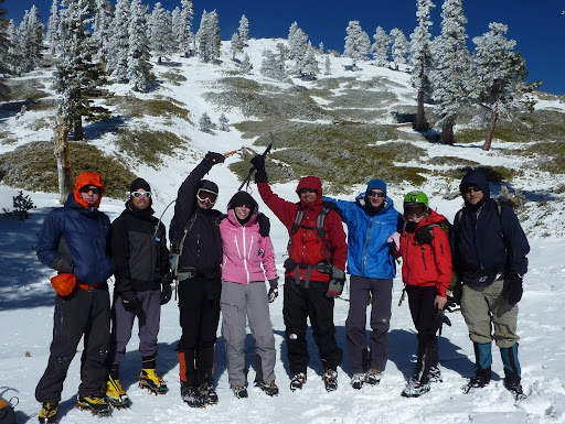 Team Hypoxia 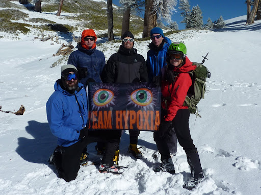 Graham, sorry we didn't run into you. Beautiful clear shot of the shoreline and ocean you got. Nice! Amazing that from the below zero, spindrift blowing summit of Baldy you can see the calm sun-kissed Pacific and vice versa. Only in Southern California!  Rest of my pix are here: http://picasaweb.google.com/ryan.norma81/MtBaldy112810#
|
|
|
|
|
Joined: Oct 2007
Posts: 783
Member
|
|
Member
Joined: Oct 2007
Posts: 783 |
Nice pix, looks like a fun and frosty day 
|
|
|
|
|
Joined: Jan 2009
Posts: 42
Member
|
|
Member
Joined: Jan 2009
Posts: 42 |
Looks like fun! I have never been up Baldy before. Is the trail marked? Anybody have a link to GPS "waypoint map" of the different trails? I am thinking about heading up tomorrow morning...gotta get out of the office!
|
|
|
|
|
Joined: May 2007
Posts: 585
Member
|
|
Member
Joined: May 2007
Posts: 585 |
Looks like fun! I have never been up Baldy before. Is the trail marked? Anybody have a link to GPS "waypoint map" of the different trails? I am thinking about heading up tomorrow morning...gotta get out of the office! I have one posted on Wikiloc here.
|
|
|
|
|
Joined: Jan 2010
Posts: 86
Member
|
|
Member
Joined: Jan 2010
Posts: 86 |
Yes, great time last Sunday and good to see everyone! Some fun conditions indeed. Thanks for sharing, Norma, and good to see you. Here are a couple of my pics:   Lots of spindrift. Did anyone see or get a shot of that big hairy dude that was hanging out on the summit? Maybe he frooze and and in few thousand years we'll dig up encino man. The rest of the pics are here.
Last edited by Ryan B; 12/03/10 04:24 PM.
|
|
|
|
|
Joined: Jul 2006
Posts: 629
Member
|
|
Member
Joined: Jul 2006
Posts: 629 |
LOL, no but I think this was taken from the webcam. Ryan you'll have to help me film Part 2 this year looking for more rugged intense winds though!!1 http://www.youtube.com/watch?v=bux6OD_iE8UYeti
|
|
|
|
|
Joined: Jan 2010
Posts: 86
Member
|
|
Member
Joined: Jan 2010
Posts: 86 |
Yeah, next time we'll bring you one of those wind surfing kites and your snow board and we'll see if we can get you to fly over to San Gorgonio!
|
|
|
|
|
Joined: Aug 2003
Posts: 492
Member
|
|
Member
Joined: Aug 2003
Posts: 492 |
I had a great time hiking with everyone again. It felt good to be back in the mountains! The Ski Hut as seen from Register Ridge... Wes always needs to get some rock climbing in... Wes always needs to get some rock climbing in... Happy Norma at the Harwood/Baldy saddle (WINDY!)... Happy Norma at the Harwood/Baldy saddle (WINDY!)... Lori putting on her crampons in the spindrift... Lori putting on her crampons in the spindrift... The rest of my pics are here.
|
|
|
|
|
Joined: Oct 2005
Posts: 353
Member
|
|
Member
Joined: Oct 2005
Posts: 353 |
Hey GigaMike, good to see you're back in the game and thanks for sharing the great photos. Looks like you folks had a bit'o wind. Amazing how much difference a week makes. Here's Mt Harwood today (Sunday, Dec-5) with hardly any snow  Cheers, RickG
|
|
|
|
|
Joined: Jan 2010
Posts: 86
Member
|
|
Member
Joined: Jan 2010
Posts: 86 |
Yes Mike, glad your back. Good seeing you and thanks for sharing the pics. Next time I'll head up the ridge with you guys...We definitely need more snow though.
|
|
|
|
|
Joined: Jan 2009
Posts: 42
Member
|
|
Member
Joined: Jan 2009
Posts: 42 |
Looks like fun! I have never been up Baldy before. Is the trail marked? Anybody have a link to GPS "waypoint map" of the different trails? I am thinking about heading up tomorrow morning...gotta get out of the office! I have one posted on Wikiloc here. Thanks for the Map tracks! I looked at them and thought that it was painfully obvious which way to go and so, in my infinite wisdom, didn’t pay attention to my GPS unit until it was too late. I, on accident, ended up going through what I believe was “The Notch” and across the devil’s backbone. Lesson leaned. A map & GPS don’t work if you don’t use them. I am considering going up again this weekend to take the route you actually suggested.
|
|
|
|
|
Joined: May 2007
Posts: 585
Member
|
|
Member
Joined: May 2007
Posts: 585 |
Thanks for the Map tracks! I looked at them and thought that it was painfully obvious which way to go and so, in my infinite wisdom, didn’t pay attention to my GPS unit until it was too late. I, on accident, ended up going through what I believe was “The Notch” and across the devil’s backbone. Lesson leaned. A map & GPS don’t work if you don’t use them. I am considering going up again this weekend to take the route you actually suggested. Glad you found it of use. I put another variation of it here. This variation includes the so-called Register Ridge. On Saturday I ascended Register Ridge, took the Devils Backbone to the summit, and returned as far as the low point in the saddle, and then headed down the bowl to the Ski Hut. That portion of the hike is the track to the right (East) of the bowl.
|
|
|
|
|


