|
|
Joined: Apr 2010
Posts: 40
Member
|
|
Member
Joined: Apr 2010
Posts: 40 |
Having never been on Whitney MT or MR, I have been wondering if there is ever a time when one would actually feel safer doing the MR vs climbing the chute on the main trail when the switchbacks are covered in snow.
|
|
|
|
|
Joined: Jun 2005
Posts: 101
Member
|
|
Member
Joined: Jun 2005
Posts: 101 |
NO. Well maybe in ones dreams. Can't think of any other time.
Last edited by hillbasher; 05/26/10 08:07 PM.
|
|
|
|
|
Joined: Jun 2003
Posts: 5,450 Likes: 13
Member
|
|
Member
Joined: Jun 2003
Posts: 5,450 Likes: 13 |
Having done both more times than I'd care to count...
I've never felt gripped climbing the slope (bowl, not chute) up to Trail Crest, whereas there have been a number of times heading up the Final 400' on the MR where the pucker factor was higher than I ever wanted it to be. (Hard ice under thin snow coverage is the most common cause of this.)
The west side of the crest is a different story though. (Although this isn't the case this year.) Some of the wind blown snow forms up HARD and STEEP at times and a slip on any of the traverses under these conditions would probably be your last.
|
|
|
|
|
Joined: Dec 2002
Posts: 1,871
Member
|
|
Member
Joined: Dec 2002
Posts: 1,871 |
There is no open air on the chute whereas there is on MR. The chute is a matter of having the right gear and a bit of experience. It is not much different than the Baldy Bowl, the north chutes of San G or the last chute in Icehouse Canyon up to Bighorn Peak. Heck, I have had more problems with the latter than the chute to Trail Crest.
I agree with Richard and Axeman, the west side more problem areas.
|
|
|
|
|
Joined: Aug 2003
Posts: 492
Member
|
|
Member
Joined: Aug 2003
Posts: 492 |
|
|
|
|
|
Joined: Jun 2003
Posts: 5,450 Likes: 13
Member
|
|
Member
Joined: Jun 2003
Posts: 5,450 Likes: 13 |
Neat photos Mike... Who would that climber be? Doesn't he ever use an Axe?
BTW, I failed to mention that the Main Trail side is really fun mountaineering right now... Until you get to that last two-plus miles to the summit from Trail Crest. That's about a sh**** as it always is. (If you know where to go, you can basically straight-line it from Lone Pine Lake to Trail Camp, cutting off quite a bit of distance.)
We'll see whether the foot-plus that fell this week changes my mind about it still being fun.
|
|
|
|
|
Joined: Apr 2004
Posts: 574
Member
|
|
Member
Joined: Apr 2004
Posts: 574 |
I know that guy..  And that one..  And..being the self-admitted rookie that I am..can admit that the most scared I've ever been was following Tom out on that slope to glissade that segment from Trail Crest.. Good Lord my knees were knockin'..  Yeah..some tricky footwork on the backside when there is still snow there..but God..the memories are worth the risk were worth the risk for me..(in my opinion..) Good luck.. Chris
Last edited by BeachAV8R; 05/27/10 04:17 AM. Reason: Struck through the stupid comment...
|
|
|
|
|
Joined: Aug 2003
Posts: 492
Member
|
|
Member
Joined: Aug 2003
Posts: 492 |
Neat photos Mike... Who would that climber be? Doesn't he ever use an Axe? His crampons are also on his pack........  Cool pics, Chris. That was a great day!
|
|
|
|
|
Joined: May 2010
Posts: 3
Member
|
|
Member
Joined: May 2010
Posts: 3 |
Is the red line up the chute the way everyone is taking to trail crest instead of using the switchbacks this time of year?
|
|
|
|
|
Joined: May 2009
Posts: 117
Member
|
|
Member
Joined: May 2009
Posts: 117 |
GigaMike and Av8R - those are some GREAT shots! Virgin path and multipath!
|
|
|
|
|
Joined: Dec 2003
Posts: 447
Member
|
|
Member
Joined: Dec 2003
Posts: 447 |
Tom will also tell you, Real men glissade in shorts !
|
|
|
|
|
Joined: Jun 2003
Posts: 5,450 Likes: 13
Member
|
|
Member
Joined: Jun 2003
Posts: 5,450 Likes: 13 |
Tom will also tell you, Real men glissade in shorts ! Or, wear a diaper! BTW, I think GM is a great story-teller. Chris, you need to figure out how to make it out here again soon.
|
|
|
|
|
Joined: Dec 2002
Posts: 3,025 Likes: 5
Member
|
|
Member
Joined: Dec 2002
Posts: 3,025 Likes: 5 |
Hi The last picture with the red line captures the slope very well , two things stand out the main trail and the rock showing next to the red line , the rock next to the red line , the rock boulder field next to the red line that could be walked up for over half of the chute but then again it could be the rock some hit when they try sliding down and get out of control. Thanks Doug
|
|
|
|
|
Joined: Apr 2010
Posts: 40
Member
|
|
Member
Joined: Apr 2010
Posts: 40 |
Chris
Very cool picture of bowl/chute and the snow on the switchbacks.
Doug talked about going half way up the chute using the boulder field......I am wondering if you would be ahead to get to the top of the boulder field in the chute and then traverse over to the switchbacks and go straight up from there, using the rocks/boulders to your advantage until you get to the top.....??
|
|
|
|
|
Joined: Jun 2003
Posts: 5,450 Likes: 13
Member
|
|
Member
Joined: Jun 2003
Posts: 5,450 Likes: 13 |
Have fun rock-hopping that boulder field (and I'm being very sarcastic). I've done it when there was way too much powder to climb the snowfield. It ain't fun.
If it's not icy and it's not so soft you're postholing to your waist (which isn't very likely at this time of year), you're better off sticking to the snowfield and picking one of the many boot tracks to Trail Crest.
Some people do climb the left edge of the snowfield and then traverse on to the Switchbacks. Bob R has laid in that track many times in the past when conditions warranted it. But again, if you've got good snow in the bowl, why would you want to traverse to what is out of the way?
|
|
|
|
|
Joined: Feb 2009
Posts: 383
Member
|
|
Member
Joined: Feb 2009
Posts: 383 |
The "west side of the crest" & the pictures of the guys breaking trail with poles: Are these areas of the MT that are normally accessed in the summer, but covered over in winter? Also, that snowfield/switchback alternate route looks much steeper than any other picture/angle that I have seen to date (love it). What is the degree of the slope? (is it as steep as it looks?) What is its elevation gain? Sorry for being lazy about looking up my own figures, but some of you have notebooks filled with this sort of data.(you know who you are 
Last edited by Bee; 05/28/10 01:07 AM. Reason: compulsive query disease
The body betrays and the weather conspires, hopefully, not on the same day.
|
|
|
|
|
Joined: Dec 2002
Posts: 3,025 Likes: 5
Member
|
|
Member
Joined: Dec 2002
Posts: 3,025 Likes: 5 |
Hi Richard has a good point , I can't recall the last fatal fall in the boulder field? But then I am fairly new to the area.Thanks Doug
|
|
|
|
|
Joined: Aug 2003
Posts: 492
Member
|
|
Member
Joined: Aug 2003
Posts: 492 |
The "west side of the crest" & the pictures of the guys breaking trail with poles: Are these areas of the MT that are normally accessed in the summer, but covered over in winter? Also, that snowfield/switchback alternate route looks much steeper than any other picture/angle that I have seen to date (love it). What is the degree of the slope? (is it as steep as it looks?) What is its elevation gain? Sorry for being lazy about looking up my own figures, but some of you have notebooks filled with this sort of data.(you know who you are Yes, those pictures were taken on the JMT/MT, in the Mt. Muir area. The slope up to Trail Crest is around 30/35 degrees, not as steep as that picture makes it seem. The elevation gain is 1,600' from Trail Camp or about 1,000' where the slope actually starts. Hi Richard has a good point , I can't recall the last fatal fall in the boulder field? But then I am fairly new to the area.Thanks Doug What do you know, your just the cook
|
|
|
|
|
Joined: Mar 2006
Posts: 298
Member
|
|
Member
Joined: Mar 2006
Posts: 298 |
Tom will also tell you, Real men glissade in shorts ! He knows of what he speaks! 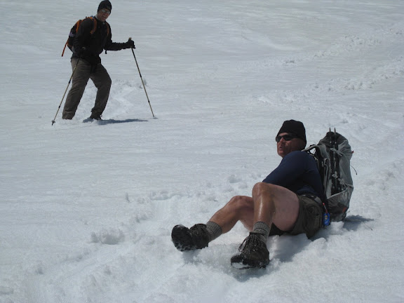
|
|
|
|
|
Joined: Jun 2003
Posts: 949
Member
|
|
Member
Joined: Jun 2003
Posts: 949 |
Thanks for reposting those photos Chris - they always bring back fond memories and they never get tiring.
Ha - I only glisade in shorts when I have a piece of fleece underneath - warm and fuzzy - mmmmmmm
|
|
|
|
|


