|
|
Joined: Sep 2006
Posts: 85
Member
|
|
Member
Joined: Sep 2006
Posts: 85 |
I am planning a trip into Tehipite Valley this summer. I will be going in from the West side, starting near Wishon reservoir. I am looking for any tips, suggestions and advice. I have heard this is called a second Yosemite by those who have trekked there. Thank you in advance for any help.
|
|
|
|
|
Joined: Aug 2006
Posts: 214
Member
|
|
Member
Joined: Aug 2006
Posts: 214 |
I went through Tehipite last year, starting at Wishon and going up to meet the JMT at Palisade Creek. The first part of the trail is dusty and wide due to large numbers of horses going to Crown Valley. Make sure you have a good map, there are a number of trails criss-crossing that area. Once you leave Crown Valley, the trail becomes faint and difficult to follow in some places. A good place to camp on the first night is at Hay Meadow. The descent into Tehipite Valley from the rim is steep (I spent the entire 3000' vertical putting the brakes on) and the trail is in poor condition, covered with leaves and loose rock. Tehipite Valley will also be fairly warm in the summer. Now for the payoff - it is a beautiful location, and you will have it to yourself (not many people are willing to make the effort to get there). Over three days, from when we left Crown Valley until we joined the JMT, we did not see another person. And there is world class fishing there. Tehipite Valley also has a reputation of having a healthy population of bears and rattlesnakes. I saw neither, but I saw an incredible amount of bear scat on the trail. 
|
|
|
|
|
Joined: Aug 2006
Posts: 214
Member
|
|
Member
Joined: Aug 2006
Posts: 214 |
Tehipite Valley is at the same elevation as Yosemite Valley, and further south, so it is dryer and warmer. There is sagebrush there, something you won't see in Yosemite. Here is a view of the main part of the valley as we got close to it: 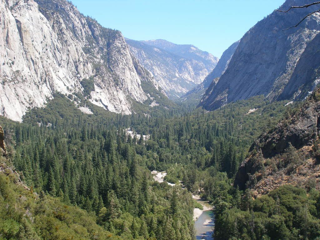 And here is Tehipite Dome, which has the same vertical as Yosemite's El Capitan: 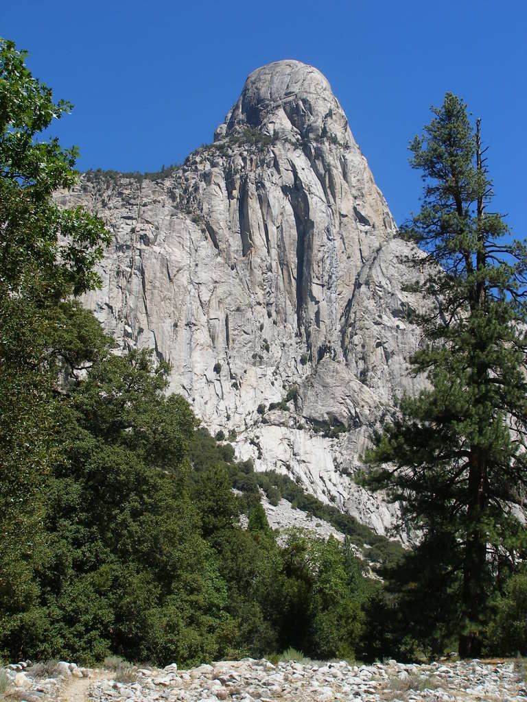
|
|
|
|
|
Joined: Sep 2006
Posts: 85
Member
|
|
Member
Joined: Sep 2006
Posts: 85 |
It inspires me even more that over 100 people have looked at this post, and only one has responded. That tells me that the valley is special, and I won't have to be worried about running into others. If you have more pictures, please post them. Also, the maps I have so far are the Kings Canyon High Country Trail Map, and the recreational map. Both of these do show alot of crossing trails as you stated. Are there markers? Any tips?
|
|
|
|
|
Joined: Aug 2006
Posts: 214
Member
|
|
Member
Joined: Aug 2006
Posts: 214 |
Are you going to stop at Tehipite, or do you plan on going further up the Middle Fork? I had the Tom Harrison Kings Canyon High Country map, and my hiking partner had the Tom Harrison Sequoia/Kings Canyon map, which shows the Rancheria trailhead where we started. Using the Sequoia/Kings Canyon map, we could figure out where to go. There are some trails near the Rancheria trailhead that are not shown on the map, just use your compass and the map to figure it out. IIRC, all of the places where we actually took a new trail there was a sign pointing to Crown Valley. And at Crown Valley there is a sign pointing to Tehipite, right by the cabins. The folks who own the operation at Crown Valley don't tolerate people camping nearby, and will run you off. I don't know what kind of arrangement they have with the forest service, or if they actually own that land, but we were moving on anyway. The worst trail section was between Crown Valley and Rodgers Creek, a stretch of a little more than half a mile. The "trail" basically followed a dry streambed, and we ended up detouring through thick cover to get around a bunch of deadfalls. I never saw the trail heading to Geraldine Lakes that the map shows, probably because we were detouring on the east side of the trail. Not long after crossing Rodgers Creek, the trail gets much easier to follow. Interestingly, although the entire section between Crown Valley and Simpson Meadow is officially unmaintained (and it was obvious between Crown Valley and Tehipite), once we got into Tehipite there were numerous locations along the Middle Fork where someone had done work with a chainsaw very recently to clear downed trees. If you are looking for solitude, this is a good place to go. Here is a picture looking back toward Tehipite Valley from our campsite at the confluence of Blue Canyon Creek and the Middle Fork. The walls and pinnacles on the left are immediately across from Tehipite Dome, which is out of view on the right. 
|
|
|
|
|
Joined: Aug 2006
Posts: 214
Member
|
|
Member
Joined: Aug 2006
Posts: 214 |
Here are some views along the way. First is a nice meadow between Rancheria and Crown Valley. The trail forked, and we weren't sure which fork to take. We followed one to this meadow, where it ended. Apparently it is a popular spot for grazing horses. 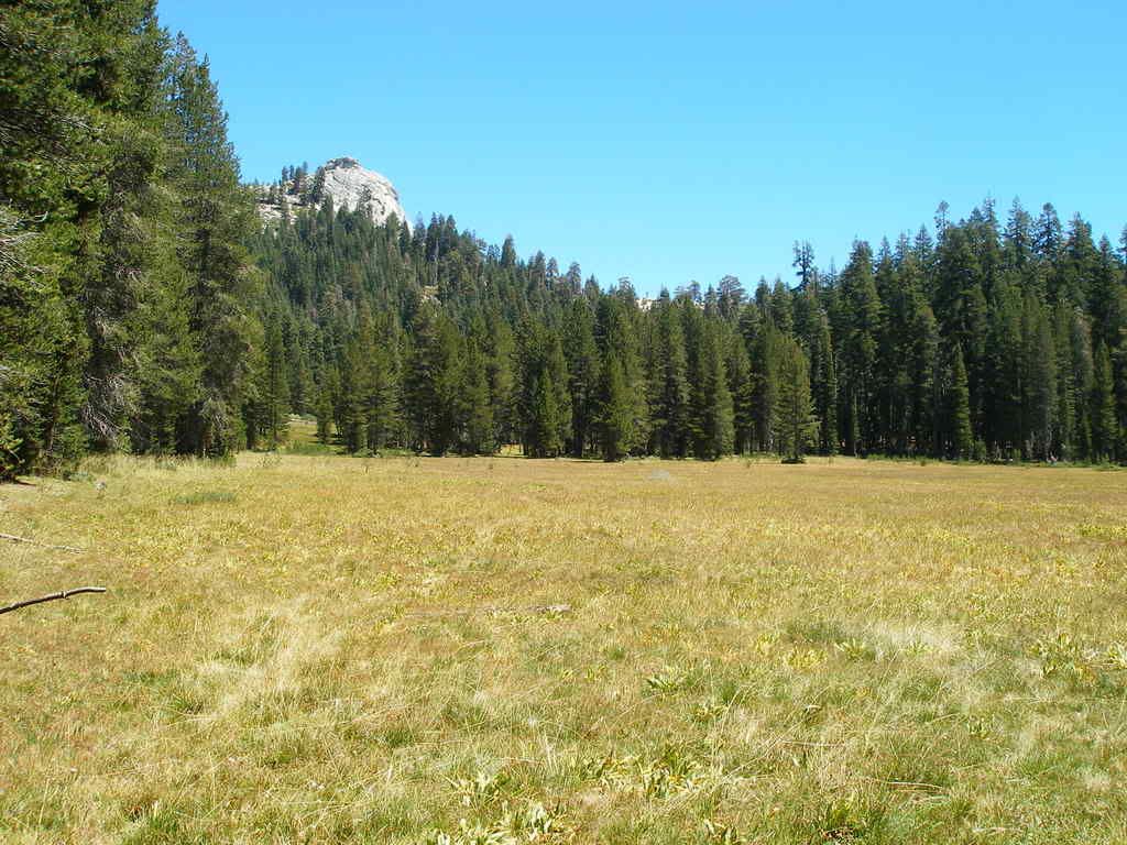 View looking down toward Crown Valley:  The meadow where we crossed Rodgers Creek. It was mid-August in an exceptionally dry year, and this meadow was very dry. 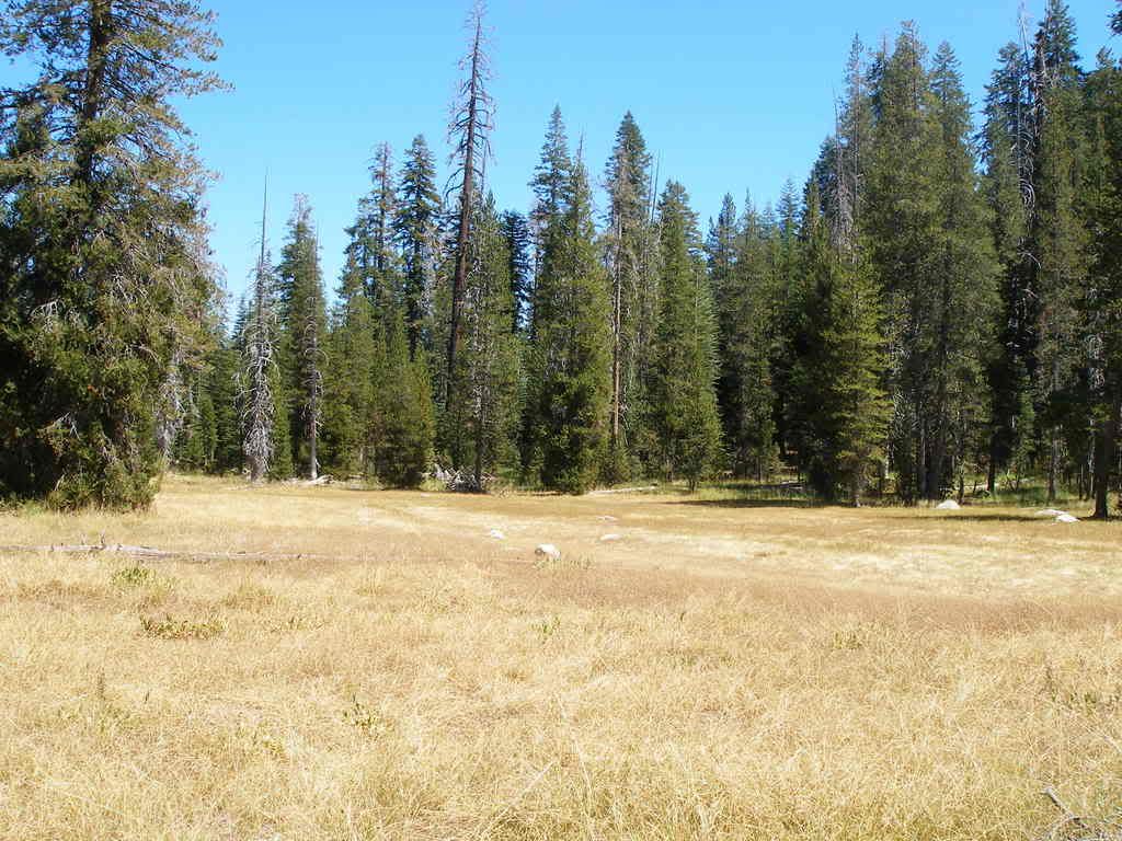
|
|
|
|
|
Joined: Aug 2006
Posts: 214
Member
|
|
Member
Joined: Aug 2006
Posts: 214 |
Looking upstream where the trail first reached the river in Tehipite: 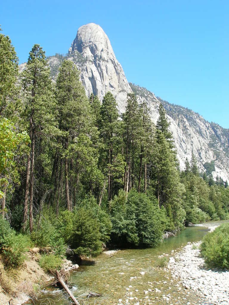 Looking downstream from the same place: 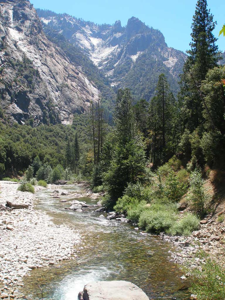 The next few are of the canyon walls on the opposite side: 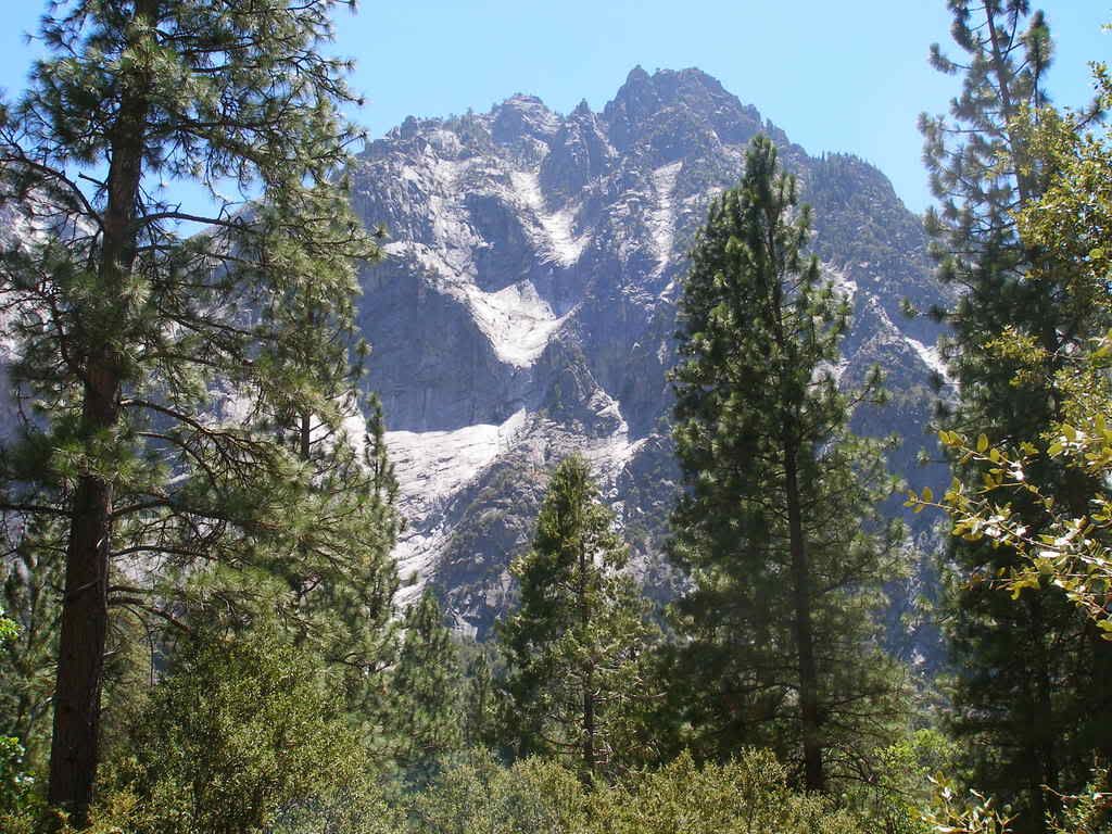
|
|
|
|
|
Joined: Aug 2006
Posts: 214
Member
|
|
Member
Joined: Aug 2006
Posts: 214 |
This one was looking across the canyon toward the upper end of Tehipite Valley proper: 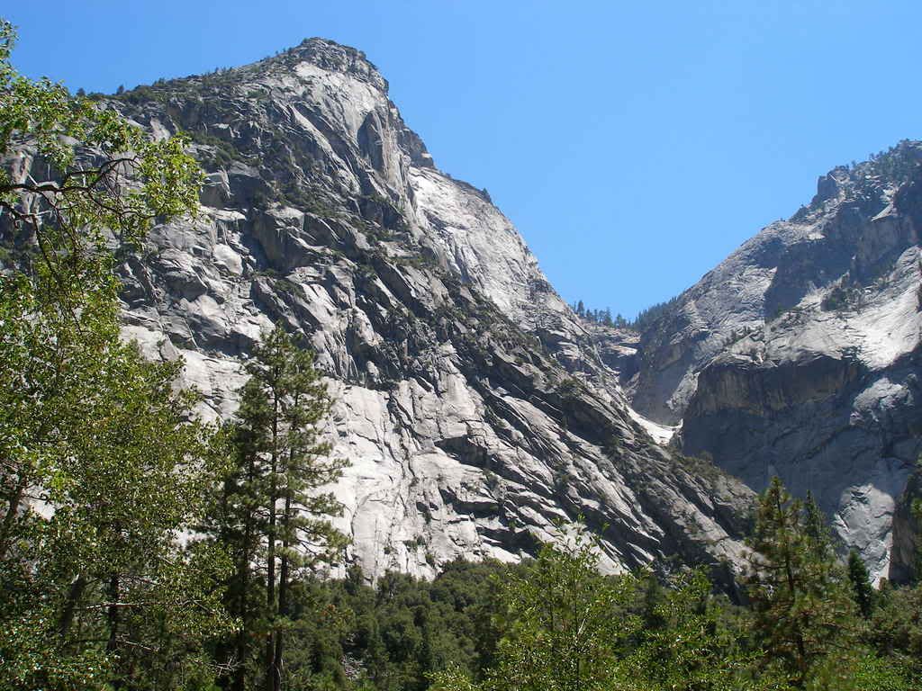 And finally, looking upstream from somewhere near the upper end of Tehipite Valley proper: 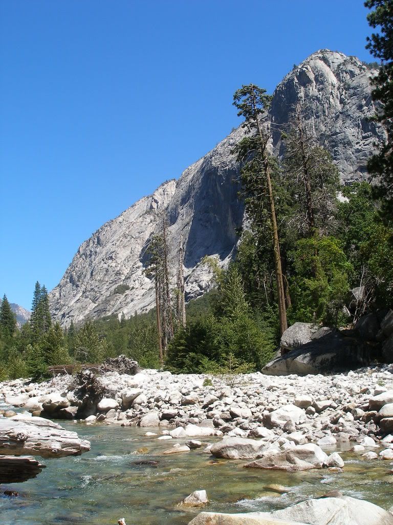
|
|
|
|
|
Joined: Apr 2004
Posts: 574
Member
|
|
Member
Joined: Apr 2004
Posts: 574 |
Good grief! What a wonderful looking place! Thank you so much for the photos...I think I found another destination to put a pin in on the map.. Anyone know how the trout fishing is there?
Chris
|
|
|
|
|
Joined: Aug 2006
Posts: 214
Member
|
|
Member
Joined: Aug 2006
Posts: 214 |
Read this trip report and look at the pictures of the trout they caught. I didn't fish when I went through, but it sure looks good. There isn't much fishing pressure because of the hard hike to get in and out. http://www.highcountryflyfisher.com/pages/chronJMW6.htm
|
|
|
|
|
Joined: Aug 2006
Posts: 214
Member
|
|
Member
Joined: Aug 2006
Posts: 214 |
And finally, not to put a damper on anything, but there is a reason so few people go there. And it's not necessarily the 17 miles from the trailhead that is the issue. From the canyon rim to the bottom are switchbacks to beat all switchbacks, 3000' vertical. Very steep and covered with loose leaves and loose rocks, and in poor condition. I had done the switchbacks on Whitney two weeks prior, and they are a piece of cake in comparison. I know someone whose cousin once went in on horseback, and his horse went down three times. And that was an experienced horseman.
But in the end it is worth it. Great wilderness all to yourself.
|
|
|
|
|
Joined: Sep 2006
Posts: 85
Member
|
|
Member
Joined: Sep 2006
Posts: 85 |
very helpful. Thanks again for advice and pictures. I am a solo backpacker, and a very cautious one at that. It is my release from my job of dealing with alot of people daily.I spend weeks every year in the backcountry. I don't plan on going any farther up the canyon, at least on this trip. I will probably spend at least two nights down there, fishing, exploring and reading. By the way, did you find any indian wall art?
|
|
|
|
|
|
Anonymous
Unregistered
|
|
Anonymous
Unregistered
|
Wow! That has got to be one of the most remote and hard to get to places in the entire Sierra wilderness. What is it... 20 miles from the nearest road? It is only about 6 miles up the Middle Fork of the Kings River from the Kings Canyon road to Cedar Grove, but there is no trail, probably due to the absolute ruggedness of the river going through. Here's a topozone link. Tehipite valley is just above and left of the center point of the map: Tehipite ValleyIt would be cool to make a Trans-Sierra trip out of it, coming in or out over Taboose Pass, which I hear is pretty brutal in itself.
|
|
|
|
|
Joined: Aug 2006
Posts: 214
Member
|
|
Member
Joined: Aug 2006
Posts: 214 |
Yep, it's pretty remote. By my calculation, it is 17 miles from the Rancheria trailhead by Wishon Reservoir to the point where the trail hits the river in Tehipite Valley.
I made it part of a very nice loop. In at Rancheria, down to Tehipite, up the Middle Fork to the JMT, south on JMT over Mather and Pinchot Passes, and then down Woods Creek and Paradise Valley to exit at Roads End in Kings Canyon. Total mileage was about 82. This loop offers such a wide variety of scenery, from deep middle elevation canyons to high alpine areas. Since I live on the west side, this was the best way for me to fill that large hole in the map of Kings Canyon where I had never been.
Unfortunately, I did not see any of the rock art.
I have read a trip report from someone who followed the Middle Fork from its confluence with the South Fork below the road that goes to Roads End. It sounded like a pretty rugged trip.
|
|
|
|
|
Joined: Jan 2003
Posts: 2,446
Member
|
|
Member
Joined: Jan 2003
Posts: 2,446 |
Interestingly, although the entire section between Crown Valley and Simpson Meadow is officially unmaintained (and it was obvious between Crown Valley and Tehipite), once we got into Tehipite there were numerous locations along the Middle Fork where someone had done work with a chainsaw very recently to clear downed trees. Out of curiousity, how did you know that the cutting had been done with a chainsaw?
|
|
|
|
|
|
Anonymous
Unregistered
|
|
Anonymous
Unregistered
|
Ken, chainsaws make a distinctive pattern in larger logs. You can see the shape of the nose of the bar. And if that recent, the wood chips are distinctive.
Cross cut hand saws would make a different mark.
|
|
|
|
|
Joined: Aug 2006
Posts: 214
Member
|
|
Member
Joined: Aug 2006
Posts: 214 |
Well, now that you mention it, I don't clearly recall if it had the distinctive marks left by chainsaws. I do know that they were large 1' to 2' logs for the most part, that were cleanly cut with absolutely straight cuts. I have done a fair amount of work with a chainsaw, and at least on a subconscious level I thought of the work as having been done with a chainsaw. And it appeared that the cutting had been done earlier that year. If it was much older than that I would be surprised.
Maybe Go Bears should investigate this next year and make it part of his trip report.
And the other fresh dust I saw was by our campsite on the last night, in the middle campsite area of Paradise Valley. There had been a large rockfall from the cliff above that brought small rocks to the edge of our campsite, and into the neighboring site. And large boulders almost that far, to the edge of the neighboring site. The rock dust from the impacts on the boulder field was still fresh. It would be pretty unnerving to wake up at night to a bunch of boulders bouncing down toward you.
|
|
|
|
|
Joined: Jul 2003
Posts: 91
Member
|
|
Member
Joined: Jul 2003
Posts: 91 |
Great post lambertiana! You know, I've been going to the Sierra Nevada since 1970, and I've never heard of this place! I've been busy getting old and fat for that past ten years or so, but have managed to get get myself back into shape. Looks like I'm giong to need to don the backpack again!
Thanks for the pics and the post!
|
|
|
|
|
Joined: Jan 2003
Posts: 2,446
Member
|
|
Member
Joined: Jan 2003
Posts: 2,446 |
Steve, you are absolutely right in your specifics. I asked the question, because my experience is that with few exceptions, only people who have extensive experience with both Chainsaw and Crosscut (two person manual) saws, are easily able to tell the difference, but assumptions are often made about what has been done. As you know, I'm a volunteer Ranger on this area of the Sierra, although I've not been into this exact area. As is also probably known, chainsaws are not permitted in this wilderness area. The packer for this area, Allen Clyde, has been known to carry a chainsaw to clear the trail for his outfit *outside of the wilderness.* (ahem) However, his is reputedly a very small model. The crosscut saws we use are capable of cutting a 48-in tree, perhaps larger. By the description, the cut would have to have been made either with a crosscut saw, or a large chain saw, with a bar long enough to cut the tree in one cut. The unfailing evidence in this case is that the cuttings with a chainsaw are sawdust, and with a crosscut are shavings, usually 1-2 inches long. Strongly suggestive is that with a chainsaw, all the sawdust is on one side, and with a crosscut, is evenly distributed on both sides. example of crosscut shavings: 
|
|
|
|
|
|
Anonymous
Unregistered
|
|
Anonymous
Unregistered
|
I could tell those shavings were from a crosscut due to their narrow and long shape before I read the text of your post. I didn't think about them being equally on both sides of the cut, but you're right. Chainsaw shavings, on the other hand, are wider, and are short -- pretty much square in shape. One other distinction about bar length -- a little 24" chain saw bar could actually cut through a 48" log (although I wouldn't want to), since it only needs to reach to the center of the log; then the other half could be cut from the other side. The packer for this area, Allen Clyde, has been known to carry a chainsaw to clear the trail for his outfit *outside of the wilderness.* (ahem) Please don't go reporting a possible violation -- I think it's a pretty stupid rule that prevents chain saws from being used for trail work while forest fire crews use them.
|
|
|
|
|


