|
|
Joined: Jun 2004
Posts: 51
Member
|
|
Member
Joined: Jun 2004
Posts: 51 |
I was considering picking up Mt. Langley via Horseshoe Meadow->Old Army in early March as a winter hike with my brother seeing as the Whitney MR isn't going to lend itself to nice skiing this year. I've never been up the Horseshoe meadow road in the winter. After googling around, I see that it is usually closed at 6,400'. Is this a gated closure or is it like the road to the Portal... drive past the closed sign at your own risk? Has anyone been up that road lately? How far can one make it with 4wd and snow tires? I've also been reading up on the Turtle Creek route. Looking at the route on google earth, the final ascent seems like it could be nasty in Winter. Are there alternate routes or is it best to go strait up the 2000' northeast col. like <a href="http://www.sierradescents.com/skiing/langley/2006/northeast-couloir.php">these guys did</a> 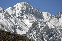 Failing all that and pending weather, perhaps a winter Carillon summit via Doug's favorite northern bowl route is in order. I imagine that bowl is beautifully desolate this time of year. =) Any feedback to help us avoid a long road slog is much appreciated!
|
|
|
|
|
Joined: Jun 2003
Posts: 5,439 Likes: 9
Member
|
|
Member
Joined: Jun 2003
Posts: 5,439 Likes: 9 |
Horseshoe Meadows Road has a locked gate and it doesn't get plowed beyond (I'm blanking on the name of the alternate road down to Lone Pine).
I'm heading up to Lone Pine on Friday and will have the skis along for a trip up around the Onion Valley area. I'll let you know whether this rececent set of storms finally put enough snow on the ground to make skis usable.
|
|
|
|
|
Joined: Jun 2003
Posts: 5,439 Likes: 9
Member
|
|
Member
Joined: Jun 2003
Posts: 5,439 Likes: 9 |
Lubken Canyon Road. (I had to look at a map!)
Tuttle Creek is the preferred approach in winter.
(Tina, I knew you wouldn't be able to stay away. There are just too many cool people posting here.) BTW, after looking at that weather link, I hope you come home with all your fingers and toes. I think you're going to find that Whitney a few weeks ago wasn't the coldest weather you've encountered.
|
|
|
|
|
Joined: May 2004
Posts: 538
Member
|
|
Member
Joined: May 2004
Posts: 538 |
Thanks Tina for the mt.washington site. I bookmarked it. Nice to see how cold it gets on one of the coldest places..
Wish whitney had a web site like that,I liked it when I clicked on current summit conditions nice layout...Have a fun trip, do you have a favorite tea to warm the bod on these cold trips...mark
|
|
|
|
|
Joined: Feb 2003
Posts: 460
Member
|
|
Member
Joined: Feb 2003
Posts: 460 |
Richard - When do you plan to go into Onion Valley. I'm headed up this weekend and if I can talk the family in letting me detour from Mammoth for a day wouldn't mind checking it out on Saturday
Richard
|
|
|
|
|
Joined: Jun 2003
Posts: 5,439 Likes: 9
Member
|
|
Member
Joined: Jun 2003
Posts: 5,439 Likes: 9 |
Since I haven't been on skis at all this year, the thought was that I do two easy days (difinitely not humping any type of load) up there. I haven't got a clue as to what the conditions are like, so it may not be anything more than a few days up in the mountains. I'll be in Lone Pine Friday and head home on Sunday.
|
|
|
|
|
Joined: Apr 2004
Posts: 574
Member
|
|
Member
Joined: Apr 2004
Posts: 574 |
Good Lord...windchill on Mt. Washington -67 right now...! Wow! Tina have fun..I went up Mt. Washington 2 years ago on my first winter climb..had an awesome time! Pics and story here: http://www.mudspike.com/lionhead.htm Hope you get great weather like I did..but looking at the isobars right now the wind is howling!! Chris
|
|
|
|
|
Joined: Jun 2003
Posts: 5,439 Likes: 9
Member
|
|
Member
Joined: Jun 2003
Posts: 5,439 Likes: 9 |
Lovin' that 100+ mph wind!!!!!
Gee, I think I'll fly out tonight and climb it tomorrow night. What phase of the moon are we in?
|
|
|
|
|
Joined: May 2004
Posts: 538
Member
|
|
Member
Joined: May 2004
Posts: 538 |
109.3mph and -70...nice day to fly a kite..
now this is where backpacker mag. gear test should pitch there tents...mark
|
|
|
|
|
Joined: Apr 2004
Posts: 574
Member
|
|
Member
Joined: Apr 2004
Posts: 574 |
Sorry we drove your post off topic Matthew :p Hope you get some answers to your questions...
Regards and have fun if you do that trip!
Chris
|
|
|
|
|
Joined: Oct 2005
Posts: 39
Member
|
|
Member
Joined: Oct 2005
Posts: 39 |
There are 2 possible routes accessible from Tuttle Creek- the northeast col and the east ridge. I snowshoed both routes as a loop hike in the heavy snow winter of 2004-2005. I would say that the east ridge is not any easier than the northeast col, but probably exposes you to a little less avalanche danger. With as little snow as the southern Sierra has received this year, I'm not sure either route would be suitable for a ski descent.
|
|
|
|
|
Joined: Nov 2005
Posts: 176
Member
|
|
Member
Joined: Nov 2005
Posts: 176 |
My partner and I had a fine time skiing Langley's NE Couloir last spring, but I should mention a few things...
* Both of us had been turned back on previous separate attempts via Tuttle Creek. The region is rough, trailless, and the starting elevation is in the 7000' range.
* Observing the the general lay of the land in the drainage, I felt that the NE Couloir exposed us to a variety of large avalanche paths, from different aspects, making (in my opinion) mid-winter travel an experts-only proposition.
* Compared to the Horseshoe/Army Pass route, I would say Tuttle is a far more remote and technical route, on par (more or less) with the Whitney MR.
That said, Langley has emerged as one of my favorite California peaks. I highly recommend the climb for those who have the skills to travel it safely.
Andy
|
|
|
|
|
Joined: Jun 2003
Posts: 5,439 Likes: 9
Member
|
|
Member
Joined: Jun 2003
Posts: 5,439 Likes: 9 |
The comment from both Doug and I on Friday afternoon is that no skiing is going to be going on up on Langley anytime soon.
There just isn't enough snow anywhere in the Sierra right now. Even Mammoth is in sad shape.
Additional reports on Doug's Tour (Cool!) and Onion Valley will follow shortly.
|
|
|
|
|


