Mt. Whitney Webcam 1

Webcam 1 Legend
Mt. Whitney Webcam 2

Webcam 2 Legend
Mt. Whitney Timelapse
Owens Valley North

Owens Valley North Legend
Owens Valley South

Owens Valley South Legend
Previous Thread
Next Thread
Print Thread
Joined: Dec 2002
Posts: 997
Likes: 2
Member
Member

Joined: Dec 2002
Posts: 997
Likes: 2
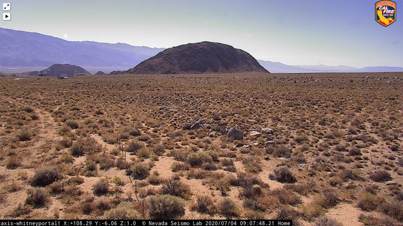
As noted in previous posts, the earthquake shifted a lot of the area highpoints. Cal-Fire has dedicated a new webcam to what is currently being verified as the region's new summit of distinction. Leading on the committee's renaming list is "Mt. Hightinerary" (since Mt. Tom is already taken)...


Joined: Jul 2007
Posts: 696
Member
Member

Joined: Jul 2007
Posts: 696
How about Mt. Pancake? Or Solifuge Peak?

Joined: Jan 2003
Posts: 974
Member
Member

Joined: Jan 2003
Posts: 974
No, no! There's really nothing special or distinct about it. And it's much too crowded already. Beside, you'll never get a permit.

Joined: May 2005
Posts: 4
Member
Member

Joined: May 2005
Posts: 4
ALERTWildfire

if you playback a 12 hour clip you will see comet NEOWISE

Actually any cam that is pointed NE with sky showing!

Last edited by WishIWereThere; 07/12/20 08:54 PM.

Moderated by  Bob R, Doug Sr 

Link Copied to Clipboard
Mt. Whitney Weather Links


White Mountain/
Barcroft Station

Elev 12,410’

Upper Tyndall Creek
Elev 11,441’

Crabtree Meadows
Elev 10,700’

Cottonwood Lakes
Elev 10,196’

Lone Pine
Elev. 3,727’

Hunter Mountain
Elev. 6,880’

Death Valley/
Furnace Creek

Elev. -193’

Powered by UBB.threads™ PHP Forum Software 8.0.0
(Release build 20240826)
Responsive Width:

PHP: 7.4.33 Page Time: 0.029s Queries: 22 (0.020s) Memory: 0.7050 MB (Peak: 0.7535 MB) Data Comp: Off Server Time: 2025-06-10 09:07:07 UTC
Valid HTML 5 and Valid CSS