|
|
Joined: Feb 2009
Posts: 25
Member
|
|
Member
Joined: Feb 2009
Posts: 25 |
I was on top of Mt. Whitney yesterday for my first time. As I was looking around, I noticed a geological survey marker. I took a closer look and couldn't read the elevation. It may have been worn off or damaged, but it really looked as if it was never printed on it. Then I noticed that this was only one of many markers up there. I didn't find any that actually had anything like the elevation or peak name or anything like that. Is there one like that up there? If so, where?
|
|
|
|
|
Joined: Mar 2007
Posts: 75
Member
|
|
Member
Joined: Mar 2007
Posts: 75 |
Last edited by icystair; 05/16/10 02:49 AM.
|
|
|
|
|
Joined: Oct 2006
Posts: 180
Member
|
|
Member
Joined: Oct 2006
Posts: 180 |
|
|
|
|
|
Joined: Aug 2006
Posts: 214
Member
|
|
Member
Joined: Aug 2006
Posts: 214 |
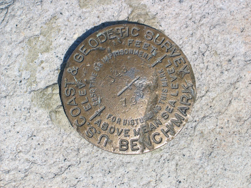
There are a number of markers on top, and none have the elevation. The one pictured above with the elevation 14,242 is not one of them (possibly North Palisade - the elevation is right for North Palisade, and the rock looks correct, the dark Inconsolable Granodiorite). Here are four of them:     In addition to those, there is a bronze disk from the California Division of Highways, and part of a aluminum marker. There is also a large plaque.
Last edited by lambertiana; 05/16/10 03:42 AM.
|
|
|
|
|
Joined: Jan 2003
Posts: 715
Member
|
|
Member
Joined: Jan 2003
Posts: 715 |
sea2summit, Check out Doug Sr.'s thread about Whitney's elevation here. The links in the discussion take you to detailed descriptions of each of Mt. Whitney's survey markers. Great photos of the markers posted in this thread!
|
|
|
|
|
Joined: Mar 2007
Posts: 75
Member
|
|
Member
Joined: Mar 2007
Posts: 75 |
There are a number of markers on top, and none have the elevation. The one pictured above with the elevation 14,242 is not one of them (possibly North Palisade - the elevation is right for North Palisade, and the rock looks correct, the dark Inconsolable Granodiorite). Thank you lambertiana for mentioning the particular marker, 14,242, not being on Mt. Whitney. I "drilled" down into the Google image and found out it was a marker on top of White Mountain. In my investigating, I found a very nice posting of pictures taken on White Mountain: Pictures . In picture 12 it shows a view of, all things, The Palisades. Is there a geologic relationship between North Palisade and White Mountain? They seem so far apart.
Last edited by icystair; 05/17/10 12:01 AM.
|
|
|
|
|
Joined: Aug 2006
Posts: 214
Member
|
|
Member
Joined: Aug 2006
Posts: 214 |
I'm still going to stick with the theory that the 14,242 marker is on North Palisade. I may be sticking my neck out since I have not been on top of North Palisade, or White Mountain, but here are my reasons to believe that the google image tag is incorrect:
1. The longstanding traditional elevation of North Palisade is 14,242', and White Mountain is 14,246'.
2. Simple geology - the marker in that picture is clearly set in dark granodiorite. The majority of the Palisade Crest ridgeline is composed of Inconsolable Granodiorite, which looks like this (although I haven't been on North Palisade, I have seen this formation elsewhere in the Palisades). The summit of White Mountain is a Jurassic metavolcanic that the geologic quadrangle describes as white, light gray, or pink. Perhaps those who have been on top of White Mountain could chime in with their personal observations of the summit geology.
|
|
|
|
|
Joined: Mar 2007
Posts: 75
Member
|
|
Member
Joined: Mar 2007
Posts: 75 |
I'm still going to stick with the theory that the 14,242 marker is on North Palisade. lambertiana, if you go to my link for pictures from White Mountain, there is a picture number 16 that shows the identical USGS marker as the closeup in my first post on this thread that was from a different source from Google images. Does USGS have a data base for their markers? Hopefully we will hear some chiming in from those with personal observations of summit geology or, even better, having photos of the marker on either summit.
Last edited by icystair; 05/17/10 06:44 AM.
|
|
|
|
|
Joined: Dec 2002
Posts: 3,025 Likes: 5
Member
|
|
Member
Joined: Dec 2002
Posts: 3,025 Likes: 5 |
Hi Every "Mark that is set and recovered has a PID # or you can can search by other methods Lat/Long or Station name and several other methods . This information will tell you the Who What, Why and how to get to the point from the closest Post Office . Each point will have a detail of what was set/ reset . You may need to look at other references to understand the difference in "marks" set. Also the long list of types of marks ie: BM, TBM, VABM, RM, ECC., RESET, AUX.,STATION,AZ, CHUCK or any name of the first party that set the point .
The site is Noaa/ ngs.gov .Search for data sheets.
Also if you find an elevation on the mark it has very little value, sometimes it was just the name of the station and a way to keep track of points set. Thanks Doug
|
|
|
|
|
Joined: Mar 2007
Posts: 75
Member
|
|
Member
Joined: Mar 2007
Posts: 75 |
Thank you Doug. The data sheet is rather complicated but I was able to find the PID on a couple of the Whitney "marks." I also found a picture of The North Palisade Sierra Club register and USGS bench mark. Not very good resolution but one can clearly see the difference from the benchmark "14,242." The type of rock might help lambertiana too.  
Last edited by icystair; 05/17/10 04:42 PM.
|
|
|
|
|