Mt. Whitney Webcam 1

Webcam 1 Legend
Mt. Whitney Webcam 2

Webcam 2 Legend
Mt. Whitney Timelapse
Owens Valley North

Owens Valley North Legend
Owens Valley South

Owens Valley South Legend
Previous Thread
Next Thread
Print Thread
#53688 09/22/08 04:06 AM
Joined: Jul 2008
Posts: 62
Member
Member

Joined: Jul 2008
Posts: 62
Climbed San Gorgonio on Saturday via the Vivian Creek Trail. We started the trail at 6am it was cold but the sky was clear. We hit the dreaded switch backs which were only a slight depiction of what this monster of a day climb was all about. It took us about 2 hours to reach Half Way camp. What it is half way to I am not sure because it sure isn't half way to the top. We pushed on and at 10:15am we hit High Creek camp and stopped for some much needed lunch, it was actually a nice camp and if I ever decided to do this hike again I would probably camp over night here. After lunch we continued on to the switch backs above and had another break right where we topped out on the ridge above which was around 12:00pm. The trail wound nicely along the ridge giving you the false hope that the worst was behind you. It was on this part of the trail that we ran into a few over night hikers who turned around without making it to the summit. Which was slightly disheartening but still we pushed on. To where you ask? The most brutal part of the climb. From the ridge you hit another hill that is one of the steepest portions of the trail and by now we had to be close to, if not over, 10,000 feet so the altitude was a factor as well but it seemed you couldn't push more then 30-50 feet with out taking a quick break to catch your breath. We hit the bottom of this steep portion at around 12:45ish and topped out at the first trail junction at 2:00pm. The good news here, the easiest part of the entire climb was ahead. Just a slight climb over the saddle and the summit was finally in view. We reached the summit at 2:30 and stayed only enough time for a few photos and a quick snack and left the summit at 2:45. Now for the long climb back down. We decended quickly to High Creek camp reaching it around 3:30. We stopped here again to refill on water and a break. The next part of the climb down seemed to take forever. It felt like we were flying down and yet getting nowhere fast at the same time and the sun was beginning to set. We didn't take another break trying to beat the sun to our car, but we lost. We had just reached the super steep switch backs above Mill Creek and the parking lot when the head lamps turned on. We continued down in the dark and since we lost our race with the sun we stopped twice for quick breaks to rest our aching feet. Finally we hear other day climbers yelling below as they reach thier cars and we knew we were close. We finally made it across the creek and to the road but since it was dark we missed the short cut and took the long way around by the cabins. We hit the parking lot at 7:41pm. This was by far the hardest day hike I have ever done but it was well worth it. So with almost 14 hours of climbing behind us we headed to In-n-Out before the quick drive home.

Joined: Jul 2008
Posts: 135
Member
Member

Joined: Jul 2008
Posts: 135
Hey there EX,

Just did that hike about 4 weeks ago. You pretty much hit the nail on the head. Although I did not write a trip report, yours works just fine.

We started @ 7:15, hit the summit @ 1:15 and got back to the car @ 6:15

That upper ridge section is truly a biznitch. I felt the same way: 50'-rest-50'-rest...and so on.

I thought after Whitney (North Fork/East Face, 60lb packs to upper boy scout) 2 week earlier it was gonna be a breeze "just running up to 11,500' with a daypack". Not so.

All in all it is a very nice trail, however long.

Anyhow, congrats on the highest summit in So Cal


Up
Joined: Jan 2003
Posts: 196
Member
Member

Joined: Jan 2003
Posts: 196
Nice report. Your description of the trail/route to the top is just about right on. I've gone up this route a few times myself. It's a good training hike for Mt. Whitney. Your trip report will help others that have never gone up the route you took. If you don't mind please post your report on the San Gorgonio Wilderness Association Board at; http://www.sgwa.org/


hiiker

Joined: Oct 2007
Posts: 783
Member
Member

Joined: Oct 2007
Posts: 783
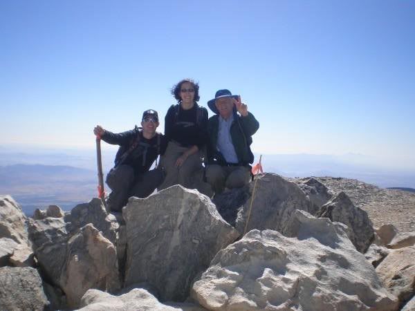
I did Vivian Creek Trail yesterday. Left at 8:30, summitted, lunched, took photos, got back to car around 5:30. I kept thinking.... how will I ever keep up with those terrific hikers on the WPSF ~ I must've still been half asleep on the way up. crazy A beautiful day. I kept thinking that the MWMT would take me twice as long.. eek.and will I ever, ever be ready for it. PS, EX3145, you live nearby me and I work nearby where you live.
I think I took this photo at the last push towards the top


It was windy up there! Did somebody steal the summit sign?

Joined: Jun 2007
Posts: 111
Member
Member

Joined: Jun 2007
Posts: 111
Ive been up San G 3 times and Whitney 3 times, and i feel that San G is a much tougher hike. I think hardest part for me, is that it just doesnt have the scenery you get in the Sierras. Thats what keeps me going. Knowing that a certian lake is just around the corner, an awesome view just over the pass, or a quick side trip summit over a ridgeline. On San G, its just hike,hike,hike, summit, hike,hike,hike, are we done yet?


What is above knows what is below, but what is below does not know what is above. Thats why i climb!
Joined: Jul 2008
Posts: 62
Member
Member

Joined: Jul 2008
Posts: 62


Here is our summit pic we just got it uploaded, should have the whole trip up soon, we took almost 100 pics lol... You know we ran into 3 very nice ladies at the summit who also live right in the same area as us. We also met 2 other climbers on the way up who were part of the Disneyland Half Marathon crew that me and my wife volunteered at. So it really is a small world lol.


Moderated by  Bob R, Doug Sr 

Link Copied to Clipboard
Mt. Whitney Weather Links


White Mountain/
Barcroft Station

Elev 12,410’

Upper Tyndall Creek
Elev 11,441’

Crabtree Meadows
Elev 10,700’

Cottonwood Lakes
Elev 10,196’

Lone Pine
Elev. 3,727’

Hunter Mountain
Elev. 6,880’

Death Valley/
Furnace Creek

Elev. -193’

Powered by UBB.threads™ PHP Forum Software 8.0.0
(Release build 20240826)
Responsive Width:

PHP: 7.4.33 Page Time: 0.042s Queries: 27 (0.025s) Memory: 0.7158 MB (Peak: 0.7817 MB) Data Comp: Off Server Time: 2025-05-01 04:05:36 UTC
Valid HTML 5 and Valid CSS