Mt. Whitney Webcam 1

Webcam 1 Legend
Mt. Whitney Webcam 2

Webcam 2 Legend
Mt. Whitney Timelapse
Owens Valley North

Owens Valley North Legend
Owens Valley South

Owens Valley South Legend
Previous Thread
Next Thread
Print Thread
#49176 06/24/08 06:42 PM
Joined: Oct 2007
Posts: 8
Member
Member

Joined: Oct 2007
Posts: 8
We're thinking about doing North Palisade via the U-Notch over the 4th of July weekend. Any beta on the route and/or current conditions would be appreciated. Some quick questions:
What's the glacier like on the approach, should we expect any crevasses and/or an open 'schrund?
Will snow conditions allow us to travel over the glacier without snowshoes?
What is the best place to camp on the approach, on the glacier, or before we get on it? If we camp off the glacier, how long will the approach be?
Will is be mostly snow, or a snow/ice mix?
2 technical tools or 1 mtn axe?
Thanks, your help is much appreciated!


Joined: Oct 2005
Posts: 61
Member
Member

Joined: Oct 2005
Posts: 61
I remember seeing some small crevasses on the glacier but roping up should not be necessary. I never did. The 'schrund might be open as summer is approaching. Snowshoes should not be necessary. Gayley camp is at the base of Mt. Gayley and just before the glacier. Good place to camp.

The U-notch climb itself is based on conditions. I remember it being mostly snow. Stay on the right side of the Notch to use the slings and other pro available. One mtn axe should be sufficient.

Here are some pictures from May '06 climb.
http://outdoors.webshots.com/album/550468922GtvPNJ?start=0

Summitpost.org has some information on getting to Gayley camp. Further research can be made for North Palisade.
http://www.summitpost.org/mountain/rock/154445/mount-gayley.html

Good luck.

Joined: Oct 2007
Posts: 8
Member
Member

Joined: Oct 2007
Posts: 8
Kevin, thanks so much for the info. Do you know how long it takes to get from Gayley camp to the base of the climb?

Joined: Dec 2002
Posts: 34
Member
Member

Joined: Dec 2002
Posts: 34
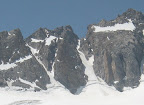
U-Notch and V-Notch are full on ice. The berg to get to the U-Notch can be crossed by a thinning snow bridge. 2 ice tools, ropes (recommend two for the rappels), screws, slings, etc - the usual, unless you will solo it. No snowshoes required.

It takes 1 to 2 hours to get to the base of the climb from Gayley. Depends on fitness level and conditions. It is a full day of climbing.

Hope this helps.

Fred

Last edited by Fred Bagni; 06/24/08 09:07 PM.
Joined: Oct 2005
Posts: 61
Member
Member

Joined: Oct 2005
Posts: 61
Hmm... The Palisade Glacier is not "that" big and I think it takes roughly 40 minutes to get from Gayley camp to the 'schrund, base of the U-Notch.

Joined: Oct 2007
Posts: 8
Member
Member

Joined: Oct 2007
Posts: 8
Do you know how many miles it is from the trailhead to Gayley camp?

Joined: Feb 2003
Posts: 460
Member
Member

Joined: Feb 2003
Posts: 460
I would say just about 7.5 miles.


Richard
Joined: Dec 2002
Posts: 593
Likes: 3
Member
Member

Joined: Dec 2002
Posts: 593
Likes: 3
RNorthe,

Of course, you can also climb to the U Notch from the southwest.. This typically involves about a 8.5 mile approach (over Bishop Pass and Thunderbolt Pass) to the base of the gully leading up to the U Notch. Once you start working your way up the chute there are several ways to reach the top of North Palisades. (I've done the Le Conte route and scouted out the Moore Variation from that side of the crest.)

With a light pack, a strong climber can ascend North Palisades via the Le Conte route as a dayhike. Otherwise, camp at a source of water as far above the Barrett Lakes as possible.

Enjoy your climb, Jim


Joined: Feb 2004
Posts: 59
Member
Member

Joined: Feb 2004
Posts: 59
Here is a pic of the notch taken yesterday (27 June 2008). Have fun!


Joined: Oct 2006
Posts: 65
Member
Member

Joined: Oct 2006
Posts: 65
Just got back from the Palisades. The bergschrund is still bridged on the right but is melting fast and may be gone soon. The first two rope lengths up past the coulior are iced. There is exposed scree most of the way on the right side. The snow level in the coulior this year is very low, we saw many old rap stations way up out of reach.


Moderated by  Bob R, Doug Sr 

Link Copied to Clipboard
Mt. Whitney Weather Links


White Mountain/
Barcroft Station

Elev 12,410’

Upper Tyndall Creek
Elev 11,441’

Crabtree Meadows
Elev 10,700’

Cottonwood Lakes
Elev 10,196’

Lone Pine
Elev. 3,727’

Hunter Mountain
Elev. 6,880’

Death Valley/
Furnace Creek

Elev. -193’

Powered by UBB.threads™ PHP Forum Software 8.0.0
(Release build 20240826)
Responsive Width:

PHP: 7.4.33 Page Time: 0.043s Queries: 34 (0.018s) Memory: 0.7382 MB (Peak: 0.8144 MB) Data Comp: Off Server Time: 2025-04-25 17:13:41 UTC
Valid HTML 5 and Valid CSS