|
|
Joined: Apr 2008
Posts: 10
Member
|
|
Member
Joined: Apr 2008
Posts: 10 |
I'm in the planning process for trying to do both White Mountain and Whitney in one weekend. I have permits for Whitney and have done it once before, so I'm all set there. I'm not sure this is the right place, but I have some questions with respect to White Mountain and I'm hoping folks can help.
1. How bad is the unpaved road? I have an all wheel drive car, but it isn't really an off road car and I'm not inclined to take it on a really rough road.
2. Are there any water sources along the way?
|
|
|
|
|
Joined: Jan 2003
Posts: 975
Member
|
|
Member
Joined: Jan 2003
Posts: 975 |
I've driven a variety of low-end rental cars on that road. It's not fun, but any car can manage it.
There is no water along the way.
|
|
|
|
|
Joined: Apr 2008
Posts: 10
Member
|
|
Member
Joined: Apr 2008
Posts: 10 |
Thanks. Did the cars take any damage? I'm not ashamed to admit that part of what I'm worried about is doing some damage to my nice car. 
|
|
|
|
|
Joined: Jun 2007
Posts: 250
Member
|
|
Member
Joined: Jun 2007
Posts: 250 |
It's been about 6 years, but we didn't think twice about taking our Honda Odyssey mini van on that road. At that time there was never a hint that we had done any damage to the car and there were cars of all kinds at the trail head.
climbSTRONG
"Avoiding danger is no safer in the long run than outright exposure. Life is either a daring adventure or nothing" -Helen Keller
|
|
|
|
|
Joined: Sep 2007
Posts: 247
Member
|
|
Member
Joined: Sep 2007
Posts: 247 |
I've been up that road 3x - once with a rental mustang and twice with crossover type vehicles. Had to take it slower with the mustang, but it was ok. Make sure you have a spare tire. Also, if you are going early or late season, you may run into some snow on some parts of the road that slope out, so this could make the normally safe road a bit hairy. It's great up there though, high altitude, barren terrain, but cool.
White Mountain and Whitney back to back would be a pretty long weekend, fyi.
|
|
|
|
|
Joined: Aug 2006
Posts: 2,391
Member
|
|
Member
Joined: Aug 2006
Posts: 2,391 |
Current conditions: White Mountain Road is clear and dry all the way to Crooked Creek, about 9 miles before the gate below Barcroft Lab. All gates are open, including the 4WD route up Silver Canyon (which, if you have a 4WD and clearance, is something I would highly recommend. Incredible views once you're up and out of the canyon!). Top of Silver Canyon, looking north on White Mtn Road:  Keep an eye out for Campito Charlie as you come into Crooked Creek/Campito Meadow:   Beyond Crooked Creek there are a few interesting drifts to negotiate, and I wouldn't try it without 4WD/clearance quite yet. But the road up to the Patriarch Grove is now mostly clear.  There are drifts covering the road into the Patriarch Grove and beyond that, but exploring the trees is always fun:    I swear this looks like Whitney's profile:  When in doubt, park and walk. We started at the Grove and chugged along the road...   [img] http://farm9.staticflickr.com/8394/8671291043_a163eba2a2_z.jpg[/img] [img] http://farm9.staticflickr.com/8521/8672392952_fa7ac5ec25_z.jpg[/img] We hiked in light boots (me) and approach shoes. Axes, no 'pons. No worries. [img] http://farm9.staticflickr.com/8537/8671293337_17cd92ffc6_c.jpg[/img] [img] http://farm9.staticflickr.com/8382/8672403044_359d691956_z.jpg[/img] [img] http://farm9.staticflickr.com/8122/8672404406_208c491daf_z.jpg[/img] West Ridge is looking clear: [img] http://farm9.staticflickr.com/8255/8671306211_bfd1d7ef86_z.jpg[/img] A gorgeous weekend up high! -L
|
|
|
|
|
Joined: Jul 2004
Posts: 74
Member
|
|
Member
Joined: Jul 2004
Posts: 74 |
Wow, the pictures say it all, some excellent photography there Laura, the Whitney profile is awesome.
|
|
|
|
|
Joined: Aug 2006
Posts: 2,391
Member
|
|
Member
Joined: Aug 2006
Posts: 2,391 |
Thanks, Phil!
|
|
|
|
|
Joined: Mar 2008
Posts: 11
Member
|
|
Member
Joined: Mar 2008
Posts: 11 |
Moosetracks - so am I reading it right - you parked about where the road takes off to the patriarch grove? And from there about how many miles is it to the summit? Looking at the topo that seems like about 12 or so - does that seem right to you?
|
|
|
|
|
Joined: Aug 2006
Posts: 2,391
Member
|
|
Member
Joined: Aug 2006
Posts: 2,391 |
Yup, sounds about right. About 12 hours round trip or so. A lovely leg stretch above 11K. 
|
|
|
|
|
Joined: Apr 2008
Posts: 10
Member
|
|
Member
Joined: Apr 2008
Posts: 10 |
Thanks for all the input. A great pictures!
|
|
|
|
|
Joined: Aug 2006
Posts: 2,391
Member
|
|
Member
Joined: Aug 2006
Posts: 2,391 |
For those interested in the northern end of the Whites: I had patients in the northern end of Hwy 6 yesterday, so I took a chance in the afternoon to see how the Queen Mine Road was looking. Well, it's completely clear, the usual rough-stuff above the lower buildings/mine, but I was able to get the TOF to the upper mine at 9200ft without much problem. The road and trail above is also completely clear (save for exactly three rapidly melting and small drifts on the trail). A 4WD w/ clearance will definitely get you to the saddle at 9700ft without much effort.  Trail Canyon from where the Queen Mine trail crests the ridge:  Queen Canyon from the same spot:  Last time I was up here was my first trail hike after my knee surgery, and it's steep but then levels out across the ridge as you head to Trail Canyon Saddle.  Little tiny flowers are out (who knew the iPhone does a decent macro??):  Now, as for Boundary, well, it's dry. I couldn't see the final ramp to the summit, but since it's south-facing, I'd extrapolate that it's the normal sand-slog.  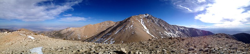  Gorgeous light as I headed for home.  All workouts should be this cool. -L
|
|
|
|
|
Joined: Oct 2008
Posts: 79
Member
|
|
Member
Joined: Oct 2008
Posts: 79 |
Amazing! Great shots, thx for sharing!
Berne Mettenleiter
|
|
|
|
|
Joined: Oct 2012
Posts: 13
Member
|
|
Member
Joined: Oct 2012
Posts: 13 |
I did my first assent of Whitney last August 2012. Went up from SoCal On a Thursday went to Horseshoe Meadows just to see what it looked like, hiked about around about a mile or so then headed up to Mt White. Stayed at Grand Veiw camp ground Thursday night then hiked up Mt White Friday and went back down to Lone Pine Friday night did all this by myself. I met up with two others for my Mt Whitney assent on Saturday and spent the day in Lone Pine. Sunday went up and had breakfast at Doug's at the Portal Store(a must if you are going to do Whitney). Hiked a few miles up the trail then went back down to Lone Pine to sleep. Got up 1 am and hit the trail around 2 am. Made the summit with no ill affects or problems.
I was 63 then and had both knees replaced in Jan and April of 2011 I had never hiked or done any type of peak bagging until about a year ago starting preparing in March 2012 with Mt Whitney as my goal. That's why I did the Mt White hike. It is an easy hike it was not as much fun to do it by my self but I did get to see a herd of mountain goats on the way up and back from the summit. I would do it again but next time with others to help the time go by easier it's a bit of plain non spectacular hike until you get to the top. Remember it's only a about 200 feet lower than Mt Whitney. Besides the altitude the only hard part of the hike is the last 1/2 mile to the summit which is all loose rock about grapefruit size.
I drove up in a 2009 Toyota Corolla no big deal
Do it, it is worth it.
Last edited by themess; 05/06/13 10:46 PM.
|
|
|
|
|
Joined: Aug 2011
Posts: 86
Member
|
|
Member
Joined: Aug 2011
Posts: 86 |
Laura, your photos from White are amazing. I don't say that a lot, they are REALLY amazing. Great exposure, impeccable color and comp to die for...
|
|
|
|
|
Joined: Aug 2006
Posts: 2,391
Member
|
|
Member
Joined: Aug 2006
Posts: 2,391 |
Thanks so much, Snacking Bear. That extremely kind of you. The first set of photos were all taken w/ my GF2, the second set with my iPhone. i was pretty surprised to see how the latter turned out!
Best,
L
|
|
|
|
|
Joined: Apr 2010
Posts: 46
Member
|
|
Member
Joined: Apr 2010
Posts: 46 |
MooseTracks! your pics are amazing!!
I aspire to shoot like that.
conditions look gr8.
From where do you pick up the Queen Mine Road? I want to go out and have a lookee.
|
|
|
|
|
Joined: Apr 2010
Posts: 46
Member
|
|
Member
Joined: Apr 2010
Posts: 46 |
and the Bristlecone Whitney Profile is king! gets me so excited
|
|
|
|
|
Joined: Apr 2010
Posts: 46
Member
|
|
Member
Joined: Apr 2010
Posts: 46 |
Bmarum - my 2cents - Ive had an unreasonable amount of flat tires on White Mtn Road past the pavement in yrs past in a 4WD Exploder . I was probly going way too fast
|
|
|
|
|
Joined: Aug 2006
Posts: 2,391
Member
|
|
Member
Joined: Aug 2006
Posts: 2,391 |
The latest storm has changed conditions considerably up there. I wouldn't expect the snow to last long, but it looks like a good dump up above 9K. It's still cloudy up there, so I'll try to post pics tomorrow when it clears. And thanks, Mr. Moon! Queen Mine Road is a few miles past the Nevada State Line. Unmarked, but I think there was an old prostitution house on the other side of the highway...
|
|
|
|
|


