|
|
#83691 - 04/13/11 04:03 PM
 Re: Mountaineer's Route Conditions
[Re: gwesely]
Re: Mountaineer's Route Conditions
[Re: gwesely]
|

Member
Registered: 06/21/05
Posts: 1006
Loc: Bishop, CA
|
Just wondering if anyone knows - ascending the MR in winter - do you need to take the standard E-ledges or with the snowpack can you just keep going up the North Fork drainage all the way to LBL. It depends from year to year. Usually during the winter/spring we can go straight up the canyon without needing to go onto the Ebersbacher Ledges. As the snow melts we eventually switch over to using the Ledges. Currently the Ledges aren't necessary. There's plenty of snow still in there. The willows are starting to get exposed though. As the snow melts it will continue to reveal more of the willows. Depending on what happens between now and when you go you may or may not need to use the Ledges.
|
|
Top
|
|
|
|
|
#83775 - 04/18/11 07:16 AM
Re: Mountaineer's Route Conditions
[Re: Kurt Wedberg]
|
Member
Registered: 09/24/10
Posts: 10
Loc: SF,CA
|
Thanks for the response Kurt. I'm hoping to go on the last weekend of April, prior to permits required. Hopefully we'll be able to go straight up the canyon. I'll be on my skis with skins, hoping to get at least some skiing in. In the upper chute above Iceberg Lake I'll strap my skis to my pack and climb with crampons if its possible to ski down the chute. What do you think the conditions will be like? We'll base camp one night at Upper Boy Scout Lake.
|
|
Top
|
|
|
|
|
#83783 - 04/18/11 09:36 PM
Re: Mountaineer's Route Conditions
[Re: gwesely]
|
Member
Registered: 01/30/03
Posts: 387
|
... I'm hoping to go on the last weekend of April, prior to permits required.... Permits are always required, but not always limited to a quota. Dale B. Dalrymple http://dbdimages.com
|
|
Top
|
|
|
|
|
#83790 - 04/19/11 04:43 AM
Re: Mountaineer's Route Conditions
[Re: gwesely]
|
Member
Registered: 11/12/10
Posts: 27
Loc: Beaumont, CA
|
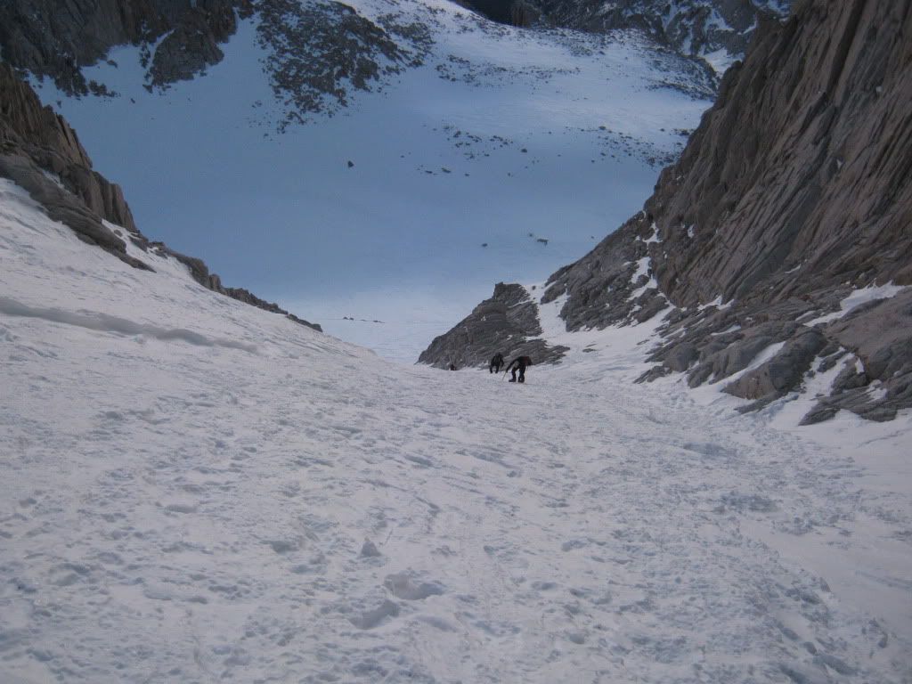
Was on the chute this last weekend before sunrise and it was perfect. The sun and warmer weather turned the lower portions of the Mountain to slush and made for some fun glissading. A guided team heading up! [img][IMG] http://i1107.photobucket.com/albums/h381/Jeffrey_Doty/IMG_5169.jpg[/img] A pick from 1/2 way down the chute.
 [/img]
Edited by dolbybear (04/19/11 04:50 AM)
|
|
Top
|
|
|
|
|
#83798 - 04/19/11 04:51 PM
Re: Mountaineer's Route Conditions
[Re: Dale Dalrymple]
|
Member
Registered: 09/24/10
Posts: 10
Loc: SF,CA
|
sorry - you're correct - no quota limit
|
|
Top
|
|
|
|
|
#83799 - 04/19/11 04:54 PM
Re: Mountaineer's Route Conditions
[Re: dolbybear]
|
Member
Registered: 09/24/10
Posts: 10
Loc: SF,CA
|
Thanks for the current pics - can you tell me what the conditions were like for skiing? - meaning was the trail from Lower Boy Scout Lake to Upper Boy Scout Lake completely covered with snow? And how about from Upper Boy Scout Lake to Iceberg Lake? Also - did you have to go up the E-ledges or did you just take the North fork drainage straight up to Lower Boy Scout Lake?
Thanks!
|
|
Top
|
|
|
|
|
#83813 - 04/20/11 04:16 PM
Re: Mountaineer's Route Conditions
[Re: gwesely]
|
Member
Registered: 11/12/10
Posts: 27
Loc: Beaumont, CA
|
The trail from lower boyscout to upper boyscout was completely covered with snow. Some of the drainage just below upper boyscout is starting to open up with about 4 feet of snow pack visable. Movement at night is really nice when the snow hardens. I was able to cruise up the "Right side" of the North Fork drainage and safely cross over 2/3 of the way up. Only 65 minutes to Lower Boyscout from North Fork Trail head and less than an hour from Lower to Upper. Total time from Portal to Iceberg was 5 hours with 2 nice water breaks and moon gazing. On the way down at 0900 AM I watched hikers busting up a snow bridge but was able to navigate OK. It was extremely warm last weekend and made for a strange hike, meaning I was freezing at 0500 at the notch and dying of heat stroke by 0800. I loved it! Make sure you hike with your "ears on" at night. You can hear the rushing water under you feet and navigate accordingly. I am not suggesting it is safe or unsafe, only that it worked for me. Hope you have fun.
Dolbybear.
|
|
Top
|
|
|
|
|
#83816 - 04/20/11 04:58 PM
Re: Mountaineer's Route Conditions
[Re: dolbybear]
|
Member
Registered: 04/20/11
Posts: 6
Loc: CA
|
I am doing MR at the end of August this year,
Is is a bad route for someone who is afraid of height? Where can i read more about preparing and training for the MR?
Thanks
|
|
Top
|
|
|
|
|
#83820 - 04/20/11 05:48 PM
Re: Mountaineer's Route Conditions
[Re: dolbybear]
|
Member
Registered: 09/24/10
Posts: 10
Loc: SF,CA
|
Thanks for the feedback - great time on getting up to iceberg lake - 65 min to LBL and less than an hour from LBL to UBL - that's fast! .... were you on skiis? Skinning up on the snow pack is much faster than hiking or snow shoeing - and then you get to ski down. That's my plan and from your description it sounds like there will be plenty of snow to make it possible. Sounds like you also came in at night? Was the snow just hard or was it icy and slick at night? I've done the 3am start before but never in the middle of the night.....sounds potentially fun if there is a full moon. I usually base camp at UBL, but if it's fast going up maybe I'll base camp at Iceberg. How are the conditions and snow coverage between UBL and Iceberg? And from the top of the chute, if the notch is too icy (I'll have no ropes) is the traverse around to the main trail an option - or did that cross-slope appear too treacherous? I've done the MR many times in summer and fall but this will be my first winter/snow attempt so I'm not sure of what to expect at certain junctures.
|
|
Top
|
|
|
|
|
#83856 - 04/21/11 07:30 PM
Re: Mountaineer's Route Conditions
[Re: Kurt Wedberg]
|
Member
Registered: 04/18/11
Posts: 5
Loc: wi, milwaukee
|
What would be the best protection for the MR route in the chutes for a trip in late may. Picketts? Are there good spots for CAM's, Nuts, etc. Would it be worth brining a couple ice screws?
thanks
|
|
Top
|
|
|
|
|
#83857 - 04/21/11 07:43 PM
Re: Mountaineer's Route Conditions
[Re: danperrault]
|
Member
Registered: 08/14/03
Posts: 492
Loc: Rancho Cucamonga, Ca.
|
I believe your best bet would be slinging rocks. Ice screws will be useless and I don't think there will be enough snow for pickets. Maybe a small rock rack. Kurt Wedberg guides up there and would know the best.
|
|
Top
|
|
|
|
|
#83868 - 04/22/11 04:32 AM
Re: Mountaineer's Route Conditions
[Re: GigaMike]
|
Member
Registered: 09/29/07
Posts: 247
Loc: New York
|
Great photos! Do you have any from the last 400ft?
|
|
Top
|
|
|
|
|
#83920 - 04/25/11 06:07 PM
Re: Mountaineer's Route Conditions
[Re: nyker]
|
Member
Registered: 07/16/07
Posts: 696
Loc: California
|
So how are things looking in the NF and main trail? Slush/posthole fest or decent consolidation (at least in the cooler morning)?
|
|
Top
|
|
|
|
|
#83978 - 04/29/11 07:08 PM
Re: Mountaineer's Route Conditions
[Re: Kurt Wedberg]
|
Member
Registered: 04/29/11
Posts: 1
Loc: Riverside, CA
|
Does anyone know what the current conditions are? Can you drive to the store as of yet? I am assuming no snow shoes are necessary>? thanks for any input in advance.
|
|
Top
|
|
|
|
|
#84017 - 05/02/11 05:46 PM
Re: Mountaineer's Route Conditions
[Re: tinaballina]
|
Member
Registered: 05/02/11
Posts: 2
Loc: San Diego, CA
|
Road is open to the store. We went up to summit this weekend and did not need snow shoes. We did need crampons for going up the long steep snow bank (where there are normaly switchbacks in the summer) from trail camp to trail crest. We did have great weather the whole weekend. No wind at camp or summit. We had an awesome last no lottery permit weekend.
|
|
Top
|
|
|
|
|
#84041 - 05/04/11 12:48 AM
Re: Mountaineer's Route Conditions
[Re: jonco4]
|
Member
Registered: 04/12/10
Posts: 55
Loc: San Diego, CA
|
Excellent! Thank you for the beta.
|
|
Top
|
|
|
|
|
#84054 - 05/04/11 04:17 PM
Re: Mountaineer's Route Conditions
[Re: jonco4]
|
Member
Registered: 07/16/07
Posts: 696
Loc: California
|
Thanks for the info. Anyone up the NF recently? Curious how things are below LBSL.
|
|
Top
|
|
|
|
|
#84065 - 05/04/11 08:20 PM
Re: Mountaineer's Route Conditions
[Re: Hiiro24]
|
Member
Registered: 01/12/03
Posts: 715
Loc: Charlotte, NC
|
Hiiro24,
In August you would need to climb the Ebersbacher Ledges and the final 400 feet. This would not be good for those who are fearful of heights, let alone rock climbing. There is plenty of exposure in both areas to keep the adrenaline flowing for even experienced climbers (which helps them be extra careful). Mistakes are not allowed.
If such a person would be comfortable with an experienced climber and could control the fear, then maybe. Otherwise, I would recommend doing some kind of small preparatory climbing to help overcome the fear, if that is possible. Other than that, it would be best to stick to the Main Trail. Whitney is to be enjoyed and not to be frightened to death.
|
|
Top
|
|
|
|
|
#84087 - 05/06/11 03:09 AM
Re: Mountaineer's Route Conditions
[Re: Wayne]
|
Member
Registered: 01/29/11
Posts: 157
Loc: Cape Cod
|
Secor says that the class 3 up final 400 can be avoided by a contour traverse right from the notch to the northwest slope. Others claim to have avoided the E-ledges by bushwhacking the willows.
No?
|
|
Top
|
|
|
|
|
#84088 - 05/06/11 03:59 AM
Re: Mountaineer's Route Conditions
[Re: saltydog335]
|

Member
Registered: 12/16/02
Posts: 2955
Loc: Whitney
|
Hi Salty You can do many things to avoid the ledges and the last 400'. Stay on the Mount Whitney Trail that is well traveled and avoids all the risk you would face on the Mountaineer's route.
The traverse that Mr. Secor alludes to has some very basic problems , First it has caused several fatal accidents and on the return from the summit many have trouble finding the return notch back to Iceberg. A fall from the traverse can place you near Artic lake 1000'+ below . Search for the accidents . Thanks Doug
Thought more about this last night , first if it is class 3 why do we have fatal accidents from falls , I hear of people placing gear on the route , class 3 is walking with limited use of hands and some risk of falling.Why would non climbers select a route with this risk ?
When the person wrote and published the walk off he placed it in the beta for the climbing routes off the face, We had years of drought and the west side was dry, the ice that was normal on this area was gone , the loose dry scree did offer a way off for climbers, but once we started getting snow and a return to normal people started falling that used this route, after the third fatal accident a small group got together and tried to determine why the accidents started happening , most likely hikers not climbers were not sure they could do the last 400'.
The walk off looks simple and they can see tracks that others have used the route. If one stands at the notch you can see the exit tracks south onto the west slope , what you do not see is the exposed 1500' of travel to get to that point, very loose gravel will cover blue ice on this section and most falls happen the first 100', two bodies were recovered at a location 15' apart at Artic Lake .
The degree of slope and the change of slope offer very little chance of recovery if one slips,and later in the summer from the south back to the notch the scree can be very loose, I was taken down about 100' before I was able to swim out some years ago.
I don't recall but wouldn't this above information be common knowledge now? Thanks Doug
Edited by Doug Sr (05/06/11 02:43 PM)
|
|
Top
|
|
|
|
|
|


 Previous Topic
 Index
Index