I just got down from back to back trips on the MR March 10-13, and 16-18. Conditions change all the time but here are a few things I found:
*There's more snow in the North Fork Cyn below Lower Boyscout Lake than I've seen in 3+ years. 98% of the willows are covered. The snow is as unconsolidated as always but if you're fortunate enough to follow someone else's boot/snowshoe tracks it is pretty firm.
*The road is melted out to the lower end of the Portal (Meysan Lakes trailhead area). Lots of rocks are strewn across the road as usual.
*In addition to the Road Closed sign there are several big boulders across the road.
*The snowpack is pretty stable with low avalanche risk. There are still the problem areas that I always watch for. Some of the most hazardous areas are the ice at about 9500' across from the Ebersbacher Ledges, and the hill just below Iceberg Lake. The ice across from the E Ledges is mostly covered with snow. When it warms up it'll start sliding. The slope below Iceberg Lake is relatively firm and stable at the moment. When it warms up it'll soften. Keep in mind the bottom of that slope is a great terrain trap. This is the site of the last avalanche burial in this area.
*The is about 8-10' of snow at Iceberg Lake.
*The Mountaineer's Chute has a plentiful amount of snow. The cold temperatures have kept it fairly firm.
*The final chute above the notch has good coverage on the last 2/3 of the route. The bottom third is mostly rock.
Re: Mountaineer's Route Conditions - 03/20/1104:15 AM
Kurt (or anyone else with recent beta and/or experience)- Did you use snowshoes on this trip? Is your team coming up a fixed rope on the final 400? Who is currently making the best snow shoes on the market?
Re: Mountaineer's Route Conditions - 03/20/1104:56 AM
Yeah snowshoes are a good idea. You may or may not need them. It's literally a day to day thing right now. If the temperature warms up the snow will be soft. If it stays cold the snow will probably stay more stable.
Yes that's a fixed line that I set for the group to ascend. It doesn't stay there. I put it up and took it down.
I've used Atlas snowshoes for years and like them. I know some people have been having good luck with the MSR Lightening Ascent. I haven't used them personally but I've seen others have a good experience using them.
Re: Mountaineer's Route Conditions - 03/20/1105:16 AM
Thanks Kurt! I see that you're headed back up in a week. I live on the coast (Aptos) and if the storm that has been here for the last 2 days has any moisture left by the time it hits the Sierra you will have a bunch of new snow. Best wishes on your upcoming trip. Gary
Yeah I think you're correct. I'm teaching an avalanche course right now and I'm interested to see what conditions we find in the backcountry when we dig our pits and do our snow analysis.
I'm scheduled to be back on Whitney later this week. I'll share what I can upon my return.
I was hoping to skin up/ski down Whitney tomorrow or Wednesday, but weather (mostly avalanche) considerations have postponed my trip to the weekend.
I've been following avalanche conditions on Whitney most of the season, and my sense is that things have been relatively stable/consolidated up until this storm.
I'm very interested to hear about your pit test results and snow analysis. If the ESAC downgrades to level 2, I'll likely head for the Portal to dig my own pits ASAP.
Besides snow, does anyone have an idea on where the last usable water source is along the MR?
On our trip two weeks ago, we camped at the LBSL elevation. The lower portion of the resulting stream from LBSL feeding down into the E-ledges gully is available (and convenient!) to pull water from. There are also some opening trickles from snowmelt on the southern-facing cliff bands surrounding Iceberg lake, but I would use these to fill water bottles on the way up to Iceberg -- they're somewhat distant from any potential campsites and sparse. For fuel-sake, assume you'll be boiling snow anywhere above LBSL.
I am planning to do MR this weekend. However given the current snow condition and weather forecast, I am wondering if it is a good idea to push. Maybe should wait at Lone Pine till later next week. really appreciate if anyone can update latest development up on MR later this week.
btw, I read the avalanche reports from esavalanche.org didn't see Mt Whitney mentioned in it. Is whitney covered by them or not? who/which organization will be alternative source regarding avalanche risk in Whitney area?
The best source of Mt. Whitney avalanche beta (other than your own analysis and pit tests) is the Eastern Sierra Avalanche Center. Their forecasts cover the same terrain (aspect & elevation) as the Mt. Whitney area:
Just got down from a climb up the North Fork. Avalanche conditions are HIGH in the area right now. Things should settle down after the sun has worked on the snow for a while but this may take a week or more. I was amazed to see people heading up there without transceivers or any knowledge of avalanche awareness. Here are a couple pictures from Sunday March 27 plus a video showing all the wind that created wind loading on many slopes.
You can watch our friend dmatt's web site for the updated forecast at http://www.easternsierraforecast.com. The weather is supposed to warm up over the next week. This will eventually help the snow become more stable but until that happens there will be a period of time of weak snowpack while things slide and settle. Keep in mind that if natural avalanches are happening the chances of human triggered slides are much higher.
At 10,600' conducting a shovel compression test to try to gauge snow stability. This is the isolated column we made.
Before conducting the compression tests I stuck my shovel behind the column.
The top 20cm of snow slid off immediately.
I continued with the shovel compression test and we found 3 weak layers at 30cm, 70cm, and 80cm... all of it part of the new snowpack. For those of you who know this test. These layers failed at CT12, CT13, And CT17 respectively.
Two of my guides with me as we watched the results of the shovel compression test. This pit was dug down 1 meter, all of which was part of the new snowpack.
There was lots of sliding going on all aspects from north to south and everything in between.
A video from Lower Boyscout Lake showing the winds above. It was an impressive sight. Gusts were hitting 90+ mph over the crest of the Sierra. As the wind scours some slopes it will load all the snow on other slopes.
Hey Kurt, thanks for the conditions report. It's nice to actually know exactly what your talking about after learning all this in your class. Thanks again!
Just wondering if anyone knows - ascending the MR in winter - do you need to take the standard E-ledges or with the snowpack can you just keep going up the North Fork drainage all the way to LBL. I'm thinking of doing a hike/ski up and down MR in the next couple of weeks with skins/AT gear as well as crampons and ice axe for the chute.
Just wondering if anyone knows - ascending the MR in winter - do you need to take the standard E-ledges or with the snowpack can you just keep going up the North Fork drainage all the way to LBL.
It depends from year to year. Usually during the winter/spring we can go straight up the canyon without needing to go onto the Ebersbacher Ledges. As the snow melts we eventually switch over to using the Ledges. Currently the Ledges aren't necessary. There's plenty of snow still in there. The willows are starting to get exposed though. As the snow melts it will continue to reveal more of the willows. Depending on what happens between now and when you go you may or may not need to use the Ledges.
Re: Mountaineer's Route Conditions - 04/18/1107:16 AM
Thanks for the response Kurt. I'm hoping to go on the last weekend of April, prior to permits required. Hopefully we'll be able to go straight up the canyon. I'll be on my skis with skins, hoping to get at least some skiing in. In the upper chute above Iceberg Lake I'll strap my skis to my pack and climb with crampons if its possible to ski down the chute. What do you think the conditions will be like? We'll base camp one night at Upper Boy Scout Lake.
Re: Mountaineer's Route Conditions - 04/19/1104:43 AM
Was on the chute this last weekend before sunrise and it was perfect. The sun and warmer weather turned the lower portions of the Mountain to slush and made for some fun glissading.
Thanks for the current pics - can you tell me what the conditions were like for skiing? - meaning was the trail from Lower Boy Scout Lake to Upper Boy Scout Lake completely covered with snow? And how about from Upper Boy Scout Lake to Iceberg Lake? Also - did you have to go up the E-ledges or did you just take the North fork drainage straight up to Lower Boy Scout Lake? Thanks!
The trail from lower boyscout to upper boyscout was completely covered with snow. Some of the drainage just below upper boyscout is starting to open up with about 4 feet of snow pack visable. Movement at night is really nice when the snow hardens. I was able to cruise up the "Right side" of the North Fork drainage and safely cross over 2/3 of the way up. Only 65 minutes to Lower Boyscout from North Fork Trail head and less than an hour from Lower to Upper. Total time from Portal to Iceberg was 5 hours with 2 nice water breaks and moon gazing. On the way down at 0900 AM I watched hikers busting up a snow bridge but was able to navigate OK. It was extremely warm last weekend and made for a strange hike, meaning I was freezing at 0500 at the notch and dying of heat stroke by 0800. I loved it! Make sure you hike with your "ears on" at night. You can hear the rushing water under you feet and navigate accordingly. I am not suggesting it is safe or unsafe, only that it worked for me. Hope you have fun. Dolbybear.
Thanks for the feedback - great time on getting up to iceberg lake - 65 min to LBL and less than an hour from LBL to UBL - that's fast! .... were you on skiis? Skinning up on the snow pack is much faster than hiking or snow shoeing - and then you get to ski down. That's my plan and from your description it sounds like there will be plenty of snow to make it possible. Sounds like you also came in at night? Was the snow just hard or was it icy and slick at night? I've done the 3am start before but never in the middle of the night.....sounds potentially fun if there is a full moon. I usually base camp at UBL, but if it's fast going up maybe I'll base camp at Iceberg. How are the conditions and snow coverage between UBL and Iceberg? And from the top of the chute, if the notch is too icy (I'll have no ropes) is the traverse around to the main trail an option - or did that cross-slope appear too treacherous? I've done the MR many times in summer and fall but this will be my first winter/snow attempt so I'm not sure of what to expect at certain junctures.
What would be the best protection for the MR route in the chutes for a trip in late may. Picketts? Are there good spots for CAM's, Nuts, etc. Would it be worth brining a couple ice screws? thanks
I believe your best bet would be slinging rocks. Ice screws will be useless and I don't think there will be enough snow for pickets. Maybe a small rock rack. Kurt Wedberg guides up there and would know the best.
Does anyone know what the current conditions are? Can you drive to the store as of yet? I am assuming no snow shoes are necessary>? thanks for any input in advance.
Road is open to the store. We went up to summit this weekend and did not need snow shoes. We did need crampons for going up the long steep snow bank (where there are normaly switchbacks in the summer) from trail camp to trail crest. We did have great weather the whole weekend. No wind at camp or summit. We had an awesome last no lottery permit weekend.
In August you would need to climb the Ebersbacher Ledges and the final 400 feet. This would not be good for those who are fearful of heights, let alone rock climbing. There is plenty of exposure in both areas to keep the adrenaline flowing for even experienced climbers (which helps them be extra careful). Mistakes are not allowed.
If such a person would be comfortable with an experienced climber and could control the fear, then maybe. Otherwise, I would recommend doing some kind of small preparatory climbing to help overcome the fear, if that is possible. Other than that, it would be best to stick to the Main Trail. Whitney is to be enjoyed and not to be frightened to death.
Re: Mountaineer's Route Conditions - 05/06/1103:09 AM
Secor says that the class 3 up final 400 can be avoided by a contour traverse right from the notch to the northwest slope. Others claim to have avoided the E-ledges by bushwhacking the willows.
Re: Mountaineer's Route Conditions - 05/06/1103:59 AM
Hi Salty You can do many things to avoid the ledges and the last 400'. Stay on the Mount Whitney Trail that is well traveled and avoids all the risk you would face on the Mountaineer's route.
The traverse that Mr. Secor alludes to has some very basic problems , First it has caused several fatal accidents and on the return from the summit many have trouble finding the return notch back to Iceberg. A fall from the traverse can place you near Artic lake 1000'+ below . Search for the accidents . Thanks Doug
Thought more about this last night , first if it is class 3 why do we have fatal accidents from falls , I hear of people placing gear on the route , class 3 is walking with limited use of hands and some risk of falling.Why would non climbers select a route with this risk ?
When the person wrote and published the walk off he placed it in the beta for the climbing routes off the face, We had years of drought and the west side was dry, the ice that was normal on this area was gone , the loose dry scree did offer a way off for climbers, but once we started getting snow and a return to normal people started falling that used this route, after the third fatal accident a small group got together and tried to determine why the accidents started happening , most likely hikers not climbers were not sure they could do the last 400'. The walk off looks simple and they can see tracks that others have used the route. If one stands at the notch you can see the exit tracks south onto the west slope , what you do not see is the exposed 1500' of travel to get to that point, very loose gravel will cover blue ice on this section and most falls happen the first 100', two bodies were recovered at a location 15' apart at Artic Lake .
The degree of slope and the change of slope offer very little chance of recovery if one slips,and later in the summer from the south back to the notch the scree can be very loose, I was taken down about 100' before I was able to swim out some years ago. I don't recall but wouldn't this above information be common knowledge now? Thanks Doug
Glad to get that info out there. I would say that as long as the Secor entry is stet, then no, that history is not common knowledge. At least not common enough. Impressions abound (until you get there, obviously) that the MR is a minimally exposed 3 (except for the E-ledges) and the Secor walk-off will go. And unless there is an explicit statement posted in the intro material, there will probably remain the (perhaps less prevalent) impressions posted that bushwhacking the willows will also go.
Re: Mountaineer's Route Conditions - 05/09/1101:34 AM
This is the deceptive "walk off" from the notch westward (instead of turning left and going up the final 400). Slip on the gravel or snow (Sept 2006) and you tumble to Arctic Lake.
I THINK...someone please confirm or correct me...that this is the route John Muir took.
Re: Mountaineer's Route Conditions - 05/10/1104:49 AM
This is from our trip on 05-15-2010. Thin snow covering loose rock underneath caused me to slip. Luckily my axe was all the way down as it caught my weight. That traverse was more sketchy than the notch to the summit.
Re: Mountaineer's Route Conditions - 05/10/1105:03 AM
Hey Kurt, this is Paul from the weekend of April 17th. I wanted to say thanks again for your advice! My buddies had a long and epic day on Russell. They encountered some pretty sketchy terrain and made it safely back.
I solo'd skied up/down the Mountaineer's Route on the first weekend of May. On Saturday there were 2 other people camping at UBL and several people coming down the mountain. On Sunday I had the entire place to myself. I passed 2 others skiing down the chute. It was icy so I stashed my skies at the base of the chute and crampon'd up. Two others I passed coming down the chute who had turned around at the notch. I was all alone on the upper chute and summiting at mid day. On the summit I was by myself for a while before 2 nice guys came up from the main route and made a brief appearance. I was all alone again going back down. UBL was empty as well as seemingly the entire mountain. It was fantastic to have the place to myself. As far as conditions (which are changing constantly) - see links below: Here's a link to a TON of photos: http://gallery.me.com/gwesely#100607 Here's a link to a movie I made (sort of cheesy but informative): http://gallery.me.com/gwesely#100621
Russell conditions in May 2011: Class 3 or 5.10? - 05/13/1102:31 AM
Paul, I am hoping to climb Russell via East Ridge on on May 20th with 2 friends (one is relatively inexperienced). How "epic" was the ascent last weekend by your buddies? The Supertopo guide seez in early season with high snow one is often force to traverse class 4 and 5 terrain on the ridge, rather the usual class 3 at the end of the year. I see in the photo your buddy is roped up. Did they place much or any gear, set belays? Also would skis be of any use for the lower ridge or just heinous extra weight ?
Re: Russell conditions in May 2011: Class 3 or 5.10? - 05/13/1105:30 AM
Awesome videojournal! How much extra mileage did you put on setting up all those shots of you walking away from the camera (and then having to return to retrieve the camera?!) Awesomeness!
Re: Mountaineer's Route Conditions - 05/13/1110:38 AM
George Weseley, kudos to you! I've been viewing photos and videos of Whitney for the past 39 years (and doing my own climbing). Your videography of your trip is the best I've seen of the Mountaineer's Route. Well done! You have an interesting set-up to capture the scenes while you move, like having someone right next to you walking/climbing/skiing along. Wow!
Re: Russell conditions in May 2011: Class 3 or 5.10? - 05/16/1107:54 AM
Originally Posted By Riska
Paul, I am hoping to climb Russell via East Ridge on on May 20th with 2 friends (one is relatively inexperienced). How "epic" was the ascent last weekend by your buddies? The Supertopo guide seez in early season with high snow one is often force to traverse class 4 and 5 terrain on the ridge, rather the usual class 3 at the end of the year. I see in the photo your buddy is roped up. Did they place much or any gear, set belays? Also would skis be of any use for the lower ridge or just heinous extra weight ?
I was not on the Russell climb. My buddies summited via the descent route for the Fishhook Arete since we were base camped just below Iceberg Lake. I wouldn't bother with skis for the approach.
Looking for conditions on the MR this week. We'll be headed up there for a daytrip on Saturday. I see that there's a good chance of some snow each day ... hope that heals some scars but doesn't give us powder!
I'd be VERY CAREFUL if only a few inches of snow fall. It will only hide those scars, making the potential for a dagerous fall more probable... not to mention hiding any ice on the paths.
Re: Mountaineer's Route Conditions - 06/03/1101:14 AM
Has anyone climbed the Mt. Whitney Trail in the last week or so?This is great info for the Mountaineer's route but I need info on how the trail is? I am planning on doing it in a day at the end of June but don't know if the trail will be easy to follow, especially since I'm starting out at 1:00 AM. Any guidance/info would be appreciated. thanks.
Re: Mountaineer's Route Conditions - 07/12/1101:14 AM
I just got back from a trip up the Mountaineer's Route July 9-10. Here's an update:
Creek crossings: Creeks are the fullest I can ever remember seeing. Rocks are covered that we normally use at creek crossings. The first creek crossing is also made more difficult because all the big branches we used to hold on to have been cut. The second one (just below the E Ledges) is so full you’re guaranteed to get wet from the waterfall. All the logs are wet and slick. There’s a tree that fell in between the two sections of the section of the creek. As you enter the second section of the creek all the rocks are submerged. There are some branches you can use to sneak across on. The 3rd crossing at LBSL is full but you can get across the log on the lower side.
E-Ledges: They’re all good. The only thing that’s changed is a tree fell into one of the slots of rock we normally walk through. It requires a big step up or mantle move.
Snow: There’s a couple patches just above UBSL but they won’t pose any problem even if it’s firm and hard in the middle of the night. We put on crampons at the hill just below Iceberg Lake. It’s just over ¾ full of snow. It’ll then be bare for a short section but we left the spikes on. There’s snow up to about ¾ of the way up the Mountaineer’s Chute. It’s firm and is starting to form sun cups. There isn’t a great kicked in trail although there are some tracks that were useful. Where the snow stops you could leave crampons and ice axes there if you wanted to. Above the notch there are a couple patches of snow but they can be avoided. There’s ice forming from melt freeze cycles but it shouldn’t pose a problem. You’ll be able to avoid it or step through it. There’s a snow patch at the base of the notch that’ll help you step into the route. We used the summer route on rock.
Hiiro24 must be a troll, like FlorenceB. Some people have nothing better to do.
The MR is melting fast, sun cups like giant egg cartons in the lower chute over the weekend. Rocky patches throughout. You can avoid the snow by taking the boulders. Like Kurt said, lots of runoff. The waterfall shortcut below Iceberg Lake is v. icy and slippery.
Re: Mountaineer's Route Conditions - 07/31/1103:28 AM
I am headed up the MR in August with a buddy. We had to stop at Iceberg last year due to altitude sickness. Planning on taking a bit longer to acclimate this year. I noticed some people had ropes and harnesses with them last year. Is is possible to get up the chute w/o ropes? Any recommendations? Thanks
I am headed up the MR in August with a buddy. We had to stop at Iceberg last year due to altitude sickness. Planning on taking a bit longer to acclimate this year. I noticed some people had ropes and harnesses with them last year. Is is possible to get up the chute w/o ropes? Any recommendations? Thanks
Jwhale:
You don't need ropes/gear for the MR. The people you saw with ropes and technical gear were likely heading up to climb the East Buttress, East Face, Fish Hook Arete on Russell, or maybe a new adventure.
With that said, you do have to be comfortable scrambling on 3rd class terrain. As with most 3rd class routes there are places on the MR where a slip/fall would lead to serious consequences. Nothing is hard, you just have to feel at ease on this type of terrain.
Re: Mountaineer's Route Conditions - 08/02/1111:59 AM
We will be climbing via the Mountaineer's Route on August 9-10. I understand that there has been a lot of snow melt in recent weeks. Can we leave the crampons and ice axe behind or should we plan on bringing them? Members of our party will be flying to Vegas from the Midwest and Atlanta. It would be nice to leave gear home if it is not needed.
Any beta on recent MR conditions would be appreciated.
I am fairly certain your team can leave all sharp, pointy things at home. Hopefully others will jump in if there are recent changes that you need to be aware of. Trekking poles would likely be helpful for both the stream crossings and working your way up the scree gully.
We're heading up on Tuesday to do the East Buttress and Fishhook Arete. How's the 3rd class descent down the back of Whitney? Is it icy? Should we bring micro-spikes?
And I know this is a little off-topic but has anyone been up/down Russell? What are the conditions?
Re: Mountaineer's Route Conditions - 09/13/1106:21 AM
I am planning on goin up the MR on Friday, 9/15. If anyone has been up the route this week I would love to hear what the conditions are like. I am especially interested to know if there has been any snow accumulation in the last few days.
Re: Mountaineer's Route Conditions - 09/15/1107:40 AM
anyone know how the route looks like currently? i heard we got a little snow up there this past week - staring early this year...anyone been up it recently?
thanks brother, much appreciated! curious what the chute and final 400 looks like, trying to determine if we should bring protection for climb on Sunday the 25th.
Re: Mountaineer's Route Conditions - 09/18/1104:44 AM
Team Andrew and Hugh tried to summit Whitney via the Mountaineer's Route on 9/13 but only got to 14,120 ft. There was some snow in the couloir but it was easily passable. It started snowing again while we climbed the couloir and by the time we got to the notch there was about 6 inches of new snow.
We got through the notch, but the traverse across the back side of the mountain was too treacherous. There were ice shelves with fresh snow on them from previous days plus that day's snow. It was too sketchy without crampons, ice axes, rope, or harnesses. We wouldn't have done it without all that gear plus an ice screw or 2.
Every time we ventured out, the snow would slip out from under our feet. If you fell, there are some rocks that would chew you up before you went over a precipice. It looked like it was snowing up there on 9/14 as well, so I doubt conditions have improved. You can read my journal of our trip with photos here:
awesome snapdad! thanks for the report, bummer you got turned around so close, but sounds like you made the right choice given the conditions and lack of equipment. we may be carrying protection and crampons afterall. got the following images just above the notch from OakleyDon taken on the same day...
I just got back from the Mountaineer's Route yesterday, September 17. There's no snow to speak of until you're high up in the Chute. Now is sticking more on the north facing slopes where it sees little to no sun exposure.
Above the Notch there is more snow. It sees sun for part of the day. This plus warm day time temperatures are causing it to soften up. It then freezes hard at night. These melt/freeze cycles are turning it to ice in spots making the climbing more "heads up". For some people these conditions would make for fun climbing and for others it would be unnerving.
Re: Mountaineer's Route Conditions - 09/19/1103:20 AM
Thanks for posting the pictures Kurt. I'm a little surprised you guys had nothing on but plain ol' boots. Looking at those pictures, I would have thought the final section would have been too slippery. I would have turned back seeing that thin layer of snow...but then again I'm not a pro. Thanks again.
Re: Mountaineer's Route Conditions - 09/26/1112:28 AM
Climbed on 09/22. The section above the notch had quite a bit of ice on the route. It seemed as though it was most evident on necessary holds
We opted to traverse west for approximately 150 or so yards and then ascend some unknown chute/gully. I made a video of it(despite it being rather uneventful), and posted it here so you can get an idea of conditions on that day:
Re: Mountaineer's Route Conditions - 09/29/1112:21 AM
Anyone been up past few days? My group would like to avoid ropes and class 4-5 moves ... so would love whatever insights folks have. But perhaps we're going too late in the year to avoid either of those. My climb last year (in June) was perfect.
What kind of permit is needed to go up the Mountaineer's Route and then go cross country to the area below Iceberg Lake? Does it require the Lottery permit? Also, is a permit required to hike up the peak that is just north of Lone Pine Lake? I realize this is more than the topic, but I cannot post a new topic. I have hiked the main trail up to now, but would like to just go xc and look around. I am not a technical climber. Thanks, Bob Rutledge.
What kind of permit is needed to go up the Mountaineer's Route and then go cross country to the area below Iceberg Lake? Does it require the Lottery permit? Also, is a permit required to hike up the peak that is just north of Lone Pine Lake? I realize this is more than the topic, but I cannot post a new topic. I have hiked the main trail up to now, but would like to just go xc and look around. I am not a technical climber. Thanks, Bob Rutledge.
I'm guessing you're thinking about a trip next summer? If so the current rules state you can apply for a permit six months ahead of the day you want to start your trip. It doesn't require entering the lottery unless you want to do a day trip. If it's a day trip then apply for it during the lottery.
Kurt, Thank you for your reply. I was at LP Lake last Saturday with friends, weather was perfect! I was thinking of going up the MR in November, before it starts to rain, but next summer is ok. I have looked at photo sites of people going the MR, but am not sure of how you find the start of the E. Ledges section up the North Fork. Is it a trip you should be with someone who knows the trail, or is it reasonably obvious to see where to start that section? Also, would it be dangerous to wear an old school Kelty frame pack on that section? I ask because it looks pretty narrow on parts of the ledge from the photos I have seen. Bob Rutledge
It's November now, quotas are no longer in place, but permits are always required. Don't quote me but during the quota months, I believe only 10 are allowed up the North Fork. Right now until April, just walk in to the visitor's center and get a permit.
I would recommend going with someone who has been up there, but it's not necessary. Dayhikes are fine if you know the route. If not, it may be better to backpack and give yourself more of a time cushion and leisurely pace. I can find the route at night because I've been up there a few times, however, if it's your first time and want to dayhike, it may be difficult to route find in the dark.
Getting to the Ledges is straight forward if you use the "traditional" route and creek/waterfall crossings. If you use the Elephant's Ear variation, it's not so straightforward. The Ledges themselves are easily negotiated IMO. Much wider and less scary in real life than pictures. Plenty of cairns to guide you. You'll be fine with a frame pack. Be careful with it on the Elephant's Ear though.
Thank you for your reply and the great links. Think I will bypass the Elephant Ear the first time! If I wanted to hike to Tulainyo Lake, where should I be leaving the MR trail? I saw great photos from a trip the brockwell group took on Flikr. The idea of just using a tarp instead of a tent for camping is appealing. Bob Rutledge
Re: Mountaineer's Route Conditions - 11/04/1102:55 AM
Bob, To see Tulainyo, leave the MR right after Clyde Meadows as you see Upper Boyscout Lake. Just look up, you'll see a gigantic scree slope. Most likely, you'll see a few slithering lines going up. Those are the boot tracks heading up. I don't know what shape you're in, but be forewarned, it is a TERRIBLE slog. Very loose sand/scree; you'll go up a step and slip back half a step. It'll destroy your boots and your morale. Once you make it to the top, you'll get a fantastic view of Whitney, Russell, and Carillion. Head towards the saddle of Russell/Carillion and you'll see the lake below.
In the picture, the standard route is to the right of UBSL there. Looks at the spot that looks like fine sand. You're going up that entire slope towards the "V". Russell is the highest thing in the picture to the left. Tulainyo is on the other side of course.
If you plan on backpacking, I would do it at UBSL then go up. There's not much protection beyond the scree slope. If you have to retreat, it won't be pleasant going down. Hope that helps.
Hi Thanks for the report! How was the first day , We worked in the Portal Thursday and I think Friday ,Saturday we drove up but didn't stay . I saw the truck parked in the "good" spot if you were with that group.
You should write a full report to help others understand the changing conditions and the weather forcast for that week.
Monday three hikers were flown out. I saw the copter fly into the North Fork area and was wondering if you had trouble .
This time of the year trips are very hard , unstable weather high winds and the rock and brush is somewhat covered but not enough that you can stay on the flat smooth surface that happens in several months once the heavy snows start and the guide groups set a track.
Side note I drove a couple down the other day from the Portal, I started to stop at the road closed area and ask if they were parked there, they said no at Lone Pine Campground they were told they could not drive past that point. It is rare that you cannot drive to the road closed sign , maybe a day of a storm or one day after but the road melts out quick once the sun hits it.
Past the road closed sign you are in the shadow of Lone Pine Peak and the road gets little sun until you get around the second switchback and then most years it is dry until the campground .(Shaded by the trees and canyon walls).I almost wrote the never talked about topic "why don't they plow the road" then I caught myself! Thanks Doug
Side note I drove a couple down the other day from the Portal, I started to stop at the road closed area and ask if they were parked there, they said no at Lone Pine Campground they were told they could not drive past that point. It is rare that you cannot drive to the road closed sign , maybe a day of a storm or one day after but the road melts out quick once the sun hits it.
Did they ask your opinion about the East Buttress of Mt. Muir? I told them that "Doug Sr. is the most reliabel source for info. Stop in at the Hostel..."
I climbed up to near Trail Camp with Payton (a real beautiful young woman) so she could see the route. She was planning on heading back up soon to try and get it done. Her climbing companion had mild AMS, so I had her all to myself... Very interesting talking to her about the Himalaya (and travel outside the U.S.) among other topics.
They told me they stopped in at the VC and were told not to head up the road. Why they weren't told about the Turn-Out is beyond me... And yes, the NRT had plenty of ice in the canyon.
Re: Mountaineer's Route Conditions - 02/22/1212:20 AM
Does anybody have any recent trip reports for MR? Conditions, snow depth, road closed? Is there enough snow to go up the center or do we still have to take the ledges? Any information would be appreciated, my buddies and I are thinking about going up this Friday and Saturday. Anybody else going to be up during that time?
Re: Mountaineer's Route Conditions - 02/22/1203:16 AM
Bob Pickering and I stuck our heads over the edge of the North Face of Mt. Whitney on Friday. (I forgot I wanted updated photos 'cause the brain wasn't working properly after such a difficult climb up the Main Trail.) Didn't look like good snow on the Final 400' yet.
Rumor is that at least a couple of groups heading up the NF stopped after a short climb up to LBSL because of unconsolidated snow.
The windy week may just make things a little easier next weekend. I'm still casting my vote for the Main Trail side, 'cause there's a fun snow climb on that side, and tracks that lead (led) to the summit.
I'm planning a trip next weekend (6,7,8 April) to either Mount Russel via East Ridge, or up the Mountaineer's route. Does anyone have any recent beta on conditions?
Re: Mountaineer's Route Conditions - 04/02/1212:31 AM
I am planning to head up Mountaineer's route as well around the same time. Does anyone know how the conditions are? Are mountaineering boots required or will waterproof hiking boots be sufficient? Any info is appreciated
From climbing Whitney in the last two Aprils and an attempt on Russel, I would say that normal boots would be okay (I climbed Aconcagua in Jan. and one of my buddies never used his mountianeering boots) but you will just have to make sure with absolute certainty that your crampons are secure.
On the flipside, it is supposed to be in the single digits this weekend plus wind chill so the extra insulation wouldn't be a bad thing.
My roommate and I are planning to do the MR this weekend. We would be hiking in Friday AM to camp at IBL and heading up the chute Saturday AM. Any opinions/advice on the weather forecast? (pasted below)
Thanks! Nick
Today: Sunny, with a temperature falling to around 28 by 5pm. Breezy, with a south southwest wind between 21 and 23 mph, with gusts as high as 31 mph.
Tonight: Mostly clear, with a low around 17. Wind chill values as low as -1. Breezy, with a south southwest wind between 25 and 28 mph, with gusts as high as 39 mph.
Tuesday: Mostly sunny, with a high near 28. Wind chill values as low as zero. Windy, with a south southwest wind between 25 and 31 mph, with gusts as high as 43 mph.
Tuesday Night: Snow showers likely. Mostly cloudy, with a low around 10. Wind chill values as low as -12. Windy, with a south southwest wind around 30 mph, with gusts as high as 41 mph. Chance of precipitation is 60%. New snow accumulation of 3 to 5 inches possible.
Wednesday: Snow showers. Some thunder is also possible. High near 16. West southwest wind around 21 mph, with gusts as high as 30 mph. Chance of precipitation is 90%. New snow accumulation of 4 to 8 inches possible.
Wednesday Night: A 30 percent chance of snow showers, mainly before 11pm. Mostly cloudy and breezy, with a low around 3. New snow accumulation of 1 to 2 inches possible.
Thursday: A 30 percent chance of snow showers. Mostly cloudy and breezy, with a high near 19. New snow accumulation of 1 to 2 inches possible.
Thursday Night: Snow showers. Some thunder is also possible. Cloudy and windy, with a low around 2.
Friday: Snow showers. Some thunder is also possible. Cloudy and windy, with a high near 12.
Friday Night: A chance of snow showers. Cloudy and windy, with a low around 0.
Saturday: A chance of snow showers. Cloudy and windy, with a high near 18.
Saturday Night: A slight chance of snow showers. Mostly cloudy and windy, with a low around 5.
Sunday: Mostly cloudy and windy, with a high near 23.
Yes, that was my opinion as well. The forecast looks like it could go either way, so we'll probably set up at IBL and make a decision Saturday morning. I'm just wondering what the wind and fresh snow will do to the chute...
Originally Posted By amax
I think this forecast says that you should stay at home or prepare for an ultimate High Sierra winter mountaineering experience:)
nick- u end up going? We are looking at heading up the 23rd and we have a newbee with us.. trying to figure out what its like for him to be best prepared with his gear
Yes, we are still going! Given the evolving forecast (see below), we decided to push back a day-driving up from LA tomorrow and hiking up to Iceberg Lake on Saturday once the storm has died down somewhat; and then heading up the chute early Sunday morning. Should be beautiful--sunny but still cold enough to keep the snow solid. Whatever happens, I'll take lots of pictures for you.
Nick
This Afternoon: A 20 percent chance of snow showers. Partly sunny, with a high near 14. Wind chill values as low as -9. West southwest wind around 18 mph, with gusts as high as 26 mph.
Tonight: Snow showers likely. Cloudy, with a low around 1. Wind chill values as low as -22. West southwest wind between 15 and 20 mph, with gusts as high as 28 mph. Chance of precipitation is 70%. New snow accumulation of 2 to 4 inches possible.
Friday: Snow showers. The snow could be heavy at times. Some thunder is also possible. High near 7. Wind chill values as low as -23. Breezy, with a southwest wind between 20 and 25 mph, with gusts as high as 36 mph. Chance of precipitation is 100%. New snow accumulation of 9 to 13 inches possible.
Friday Night: Scattered snow showers. Some thunder is also possible. Cloudy, with a low around -3. Wind chill values as low as -28. Blustery, with a west northwest wind between 23 and 26 mph, with gusts as high as 37 mph. Chance of precipitation is 50%. New snow accumulation of 3 to 5 inches possible.
Saturday: Scattered snow showers. Mostly cloudy, with a high near 13. Blustery, with a north wind between 22 and 26 mph, with gusts as high as 38 mph. Chance of precipitation is 40%. New snow accumulation of less than a half inch possible.
Saturday Night: Partly cloudy, with a low around 3.
Sunday: Sunny, with a high near 26.
Sunday Night: Mostly clear, with a low around 11.
Monday: Sunny, with a high near 30.
Monday Night: Partly cloudy, with a low around 16.
Just a comment: if anything close to this forecast snowfall happens with a "west" wind, the Couloir will require super-human strength because of the deep drifts that are going to form. Not to mention it might be really tough just getting up there.
I'm going to probably try the other side on a similar schedule, but don't really have any high expectations of success. Could be real beautiful...
Re: Mountaineer's Route Conditions - 04/15/1203:33 AM
First off, thanks to those who replied to my earlier post. I did climb up during the weekend of April 6-8. I made it all the way to the top of the gully and topped off around 14,138 feet. I was unable to find boot tracks to the summit and more over had a scary fall on the icy traverse behind the mountain. I slipped for around 50-60 feet before my ice axe dug in while self arresting.
Equipment taken: 1. 2 person tent 2. Mountaineering plastic boots 3. Ice axe and crampons 4. Water filter 5. "Big fluffy" (down jacket) - the best thing ever!!!
Departed around 11am from Whitney portal trailhead and made it to UBSL by 5pm with a partner. Camped there and met "Crazy" Gregg (I gave him the nickname because it was crazy to see a man walking around bare chested and with tennis shoes and only an ice axe - and he was going to run back to the trail head the same evening after reaching UBSL). The trail was in overall great condition with very minimal post-holing. I was glad to have carried in my plastic boots as they kept my feet very dry and warm. Also, we kept to the left of the stream and pretty much bypassed the E Ledges for the most part. My partner decided to call it quits as he was experiencing signs of altitude sickness. So while he camped in, I left the next morning at 6am for the summit. I reached the top of the gully at 12:00pm and was surprised that there was no one ahead of me or behind me on what seemed like an excellent day to summit. Gorgeously clear skies, light winds and perfect temps. There were a couple of guys climbing up the East Face direct but no one on MR. When I reached the top of the gully, I saw some boot tracks and followed it around the back of the mountain. Immediately I was faced with an icy patch that refused to let my crampons grab on. I somehow managed to cross it by holding on the adjacent rock and treading cautiously. But somehow this kept bothering me and I was unable to take it off my mind. I looked around for the notch to climb up but didnt find any boot tracks leading up - instead I found boot tracks traversing all the way around the mountain and that just looked like a long hard slog. At 12:30 after trying to find a suitable way up, I decided to return instead of falling victim to summit fever. The icy patch I crossed was still playing on my mind and as I came to the same on the way back, I decided to repeat the process of holding onto adjacent rocks and treading cautiously. At some point, the ice under my right foot cracked and gave way - before I knew what happened I was sliding down the steep face. I was on my side and was trying hard to get into self arrest position but the ice axe wouldnt bite into the hard ice that formed from multiple melt and refreeze cycles. Things were happening at lightening speed and I had only one goal in mind to stop!! I put my entire body weight on the ice axe and finally came to a stop amidst some rocks. I lay there for a few seconds trying to make sense of what had happened. I wiggled my fingers and toes to ensure that I hadnt broken anything - everything good. I then slowly turned myself to see where I was - wasnt too far from the edge of the precipice. Another 150 feet or so and I would be in freefall!!
I sat there for a while trying to gather my thoughts and then I tried to look up and see an alternate way. Adrenaline was still pumping hard to feel any pain or fear anything. I found an alternate way around the icy patch and made quick work of the way back to the top of the gully. It was then an uneventful return back to UBSL campsite. There I met my partner and we headed back to the trailhead. On the way back we missed the streamcrossing from E Ledges and were temporarily lost for 15 minutes. Luckily I spotted "Crazy" Gregg and yelled out to him. This time again he was hiking around in shorts and a day pack!!! He quickly spotted me and showed me the way back - much thanks to him!! He was a god send at that moment! My partner and I then slogged our way back to the trailhead and got into the car for our trip back to Lone Pine.
Once back in our motel, I had a chance to examine my injuries from the fall and while it was nothing serious, the entire left side of my body had scratches and bruises from the slide onto the rocks. My brand new helment has nice scratches and the ice axe is now legendary in my eyes!!
Scary but all ends well!! In hindsight looking at the pictures, if I had known better I would have walked around the icy patch by hiking down and then back up!! Next time!!!
Check out the member's albums. Bob R Rick Kent mine. Loads of photos that will show the way to the top up The Final 400'. There's a reason we say The Easy Traverse sarcastically.
Very lucky indeed! Kudos to you for knowing when to turn around, and for the quick reactions in your self-arrest when there was no time to think. Thanks for posting your story and VERY glad you returned to tell it.
Scary but all ends well!! In hindsight looking at the pictures, if I had known better I would have walked around the icy patch by hiking down and then back up!! Next time!!!
Congrats on the "Save of your Life".
Thank you on the detailed account of how it all went down. With the new snow, spring conditions and permit season just about to start, I took a couple of things from this that everyone should think about before the trek.
1. Do I have the right equipment? 2. Do I KNOW how to use my equipment? (i.e.Self Arrest) 3. Conditions, Conditions, Conditions!
You didn't summit which is everyone's goal, HOWEVER, YOU still got to reflect on your trip and share your experience with others.
I'd say, 70% of the time, we'd be wondering how the accident happend.
Re: Mountaineer's Route Conditions - 04/17/1203:47 AM
Sunday the 15th.
Talked to a climber who had done the climb. He said the route was crowded. There was also quite a bit of spindrift hitting them in the face as they climber up the Couloir.
Re: Mountaineer's Route Conditions - 04/18/1212:40 AM
So we did go this weekend, but we did not quite make it to the top. Had to turn back at the base of the chute due to soft, chest-deep snow and approaching darkness. We got up to the top of the big ridge between Iceberg and Upper Boy Scout (The Pinnacle maybe?) as a consolation prize.
Overall, conditions were much better than forecast (the gusts and -25 windchill predicted for Saturday turned out to be about 35 and cloudy). On the way up to Lower Boyscout we had to muscle up the hill/through the willows because the ledges were covered in about a foot of snow and a bit of ice (it's hard to see in the picture but they looked slick!) On the way up we came across a kind of step-15 foot tall (icy!) boulder slab forming a corner-we depacked and got out the rope which we used to pull up our packs (and the couple behind us).
We camped at LBSL and headed up Sunday morning with light packs and high hopes. It was absolutely beautiful out-sunny and around 40 degrees by 8:00 AM. We made great time to Upper Boy Scout-up the hill in a little over 45 minutes. With that behind us and the day still young, our chances of summiting were good. So we took a nice rest at Upper, had breakfast, enjoyed the view and took off a few layers (it was getting warm). We headed up around the corner at about 10:00. But things began to get very slow and sloggy between Upper and Iceberg. There was a lot of new snow, and a lot of knee/thigh deep postholing. We put on our snowshoes, which were extremely helpful, but even wearing them we were sinking in a good 6-12 inches. And because it was so sunny and warm (almost 60 degrees by 11:30) the top layer of snow was getting very weak and very slick. We had a lot of slips, short slides and a couple "oh ****" moments while crossing the long, steep slope on the way to Iceberg. In all in took us four hours to get there...by which time it was too late to even think about getting to the top and back to camp at Lower Boyscout before dark. In addition, a couple of climbers already in the chute were pushing through chest-deep drifts, and the wind was beginning to pick up. So we just got out the rope and climbed up to the top of the big ridge between Iceberg and Upper Boy Scout (I think it's called the Pinnacle?) before slogging back down to camp for the night.
the step
no way around it
Lower Boy Scout
looking up the valley
a lot of beautiful blue ice ripe for the climbing if anyone's feeling particularly brave
Hello All. My name is Louis and I am brand new to this message board. I've enjoyed reading everyone's stories so I though I would jump in.
I have summited Whitney in August of 2010, only got to Trail Camp in October of 2011 (too much snow on the switch backs). We just came up on the Whitney Trail on both trips.
Since my girlfriend and I did not get our dates picked during the lottery, we took the latest dates we could get during the inventory sell off and will be attempting to summit May 29/30.
This will be my girlfriends first trip to Whitney so we will stick to the Whitney Trail again.
Is this a good place to come back to as we get closer to our trip to see if anyone knows how much snow is on the switch backs between Trail Camp and Trail Crest?
Is this a good place to come back to as we get closer to our trip to see if anyone knows how much snow is on the switch backs between Trail Camp and Trail Crest? Louis
You've come to the right place. Head up to the portal store the day before you head up and talk to Doug and crew in the store. You can't get better info.
Re: Mountaineer's Route Conditions - 05/01/1203:20 AM
This board is an awesome resource. I have hit the summit twice and been turned back at IBL with snow and questionable experience level for the conditions. Doug, Richard, and the crew at the Portal Store are absolutely legendary regarding their commitment as well as the welcoming and supportive environment they provide for such a spiritual place.
Re: Mountaineer's Route Conditions - 05/14/1204:18 AM
Here are a few photos showing conditions on 5.11:
I didn't touch snow until above UBSL.
I thought the Blue Ice might put on a show for me... notice the major fractures. It's coming down soon.
Heading for Russell or Carillon?
Thought about pretending I was heading for the EB, but didn't know what the Catwalk would look like. You can see there's still a bit of snow on it... I was on snow for less than a thousand feet in the main Couloir.
The Final 400' I went across the usual traverse (right of center) and encountered very firm snow that required me to put crampons back on. (This was about 9:45am.) I skipped around the foreground snowfield.
The rest of the album: http://piotrowski.smugmug.com/Whats-New-1/Mt-Whitney-Mountaineers-Rou/22960123_kz5s8h#!i=1845337145&k=bS85CmN
I'm heading up the MR for Memorial day weekend and was wondering about the water availability at UBSL. Is there any running water available? Just wondering if the lake is still frozen, and if there's a need to melt snow for water if we camp there.
My daughter and I are coming in from Colorado. I have climbed all of the 14ers here and am wondering if someone could give me a comparison between the Mountaineer trail and one here in Colorado, perhaps with Longs (it is often climbed).
Re: Mountaineer's Route Conditions - 08/21/1202:05 AM
Well, it wasn't a major storm, but I always like to post info proving that Doug is the Mt. Whitney Sage... (RE:)_first snow in August... (prior to the 17th)
None of this existed the week before and it's probably already gone with the heat we've been experiencing.
There was a lot of water on the Final 400', so keep your eyes open for ice on the route if you're up there early in the day.
I have an overnight permit for Fri Oct 12th/Sat Oct 13th. This will be my second time up this season and 4th total. I am very interested in the mountaineers route as I would like a new challenge/adventure. I have spent lots of time studying various posts with descriptions of the route, images and topo maps. Weather permitting I would like to give it a try. I have a few questions...
1) Should I attempt it as a day trip or overnight? The E-Ledges seem a bit intimidating and I wonder if they would be easier with a day pack. Also, it seems that the route can be negotiated in less time than the main trail. I am in good physical shape (I have not struggled with the main trail and made very good time relative to others on the mountain. I also have limited class 5 rock climbing experience and am comfortable scrambling)
2) Can you point me in the direction of the route finding resources you consider most valuable (maps, photos and descriptions)?
3) What are the most common mistakes people make their first time on the route?
Re: Mountaineer's Route Conditions - 11/18/1202:46 AM
I'm considering a trip during Thanksgiving week to climb Russell. I would gladly appreciate any condition updates, esp. after this current storm rolls through. Any info regarding ice on Ebersbacher ledges or an alternative approach, amt. of snow around UBSL, snow on ridge, etc. Also, does anybody know if Whitney Portal Rd. is even open?
Notes: 1. bathrooms are open, but water is not available at the Portal 2. Used micro-spikes after the first stream crossing to the E-ledges. Took them off for the E-ledges 3. You need to use the E-ledges now, the willows in the stream bed are not covered with enough snow 4. Put the micro-spike back on at LBSL and used them all the way to Iceberg Lake 5. used crampons for the MR main gully and final-400
Nice photo's! although we have never met, i watched you heading down the descent of the final 400' yesterday as i was approaching the summit, small world.. Amazing day yesterday.. Have not figured out how to do the photo's on the message board yet, but if you go to mccoyimages.smugmug.com you can access the site..
Did Mt Whitney on the weekend of April 12-14, and conditions were fairly dry. LowerBoyscoutLake and the route up there were mostly free of snow. E-ledges were inevitable. UpperBoyScoutLake was still frozen, but there were some drainage areas. Probably best to boil or treat that water. UBL area was mostly dry, and I saw many good camping spots. The route from there to the summit of Whitney still had mostly snow: solid in the morning, but perpetual postholing in the afternoon. The snow on the chute was hard packed and great for crampons, but there was no snow on the last 1/4 to the notch. I didn't see fresh tracks on the traverse, so I scrambled up the last 400', which was free of snow and ice except on some sections. IMHO, I think it is usually best to avoid the traverse unless the snow and the tracks look very manageable.
The green line is the route that I could have taken, but instead I took the route indicated by the red line. I was trying to be courteous to the second guided group descending by staying out of their way. This was unnecessary, and my traverse to the right near the top felt a bit exposed. I should have waited until they passed me, and then I could have taken the snow bank in the middle. http://alturl.com/jfpqd [img]http://alturl.com/jfpqd[/img]
(Hmm... I'm not sure if the images are embedding into this post, so I added them as links)
MR 4/29/13 Had a great day on the MR with Bob P. and along the trail met another fellow WPSMB/Zone member Nyker who is in town for business (and also seems to have a knack for spotting animals from a distance).
Just got down off the Mountaineer's Route. Reached the summit on Saturday. After a week of stormy weather I was amazed to see more snow on the route than there has been all year. I've been up almost every week since early March. Last week the snow stopped half way up the Mountaineer's Chute. On Saturday it was continuous snow all the way to the Notch. We were sinking in up to my knees for most of the way. Above the Notch had been almost all rock. Now there's a huge drift of snow I estimate to be about 5' deep. Here are a few pictures. The rest of the pictures I took from the trip are here: Mt. Whitney May 9-12, 2013
May 11, 2013 at 6:30am: Looking up the Mountaineer's Chute.
Looking down the Mountaineer's Chute from 13,200'.
Looking up the Mountaineer's Chute from 13,200'.
From the Notch looking up towards the summit plateau.
Starting up above the Notch.
Looking down from about half way up the final 400+'
Looking up from the middle of the final 400+'
Looking down the final 400+' from a belay stance a little below the summit.
On the descent in the middle of the Mountaineer's Chute at 2:30pm.
Re: Mountaineer's Route Conditions - 05/20/1302:20 AM
What a difference a week makes. Just got down from another Mountaineer's Route climb. We reached the summit on May 18. Snow in the lower half of the MR will hang in there for another couple weeks or more depending on weather. The top half is melting out quickly. It was bare before the last storms came through a week ago so all the snow on the top half is recent. It will probably be gone within a week or two at most.
Above the Notch the snow is hanging in there. It's north facing, shady for a longer period of time during the day, and usually windy.
The lower half of the MR on the afternoon of May 18:
Appreciate the pics Kurt, I will be up the MR first week in June so any info is good, probably pick up Lone Pine Peak while I,m in the area as well. Phil
Did the MR twice on saturday the 15th. Conditions are more like August than June. Early morning ice on final 400 is easy to avoid, just agua later in the day. No ice/snow equipment necessary....
LOL been called worse. .... portal to summit via MR, back to portal, back to summit, then back to portal (was training for Rainier, weather had other plans for that trip to the PNW). I do ok for an old man....
No offense taken, just having fun with it..... Locals tell me WA has nicer weather in August than June (mileage may vary), so Rainier still on the to do list!
Re: Current Mountaineer's Route Conditions - 07/25/1303:11 PM
Probably not your train of thought, but I still recall the Eye-Popping Experience seeing the SE Couloir (trenches 2+' deep in places) on Thor Peak after the Flash Floods of a few years ago...
This is what the Main Couloir looked like last Sunday:
Only the smallest little trickle of water on the Final 400' to the summit plateau. Some of it looked like it was trying really, really hard to freeze.
Hi Road is open , the last 400' should have ice in the center and patches of snow , most years if you are a climber you can stay on rock and avoid the ice/snow, may have low class 5 moves for short sections.
Hi Road is open , the last 400' should have ice in the center and patches of snow , most years if you are a climber you can stay on rock and avoid the ice/snow, may have low class 5 moves for short sections.
Thank you very much. I am sure that all might change over the next couple of days
Hi All, I plan on a trip up MR December 27th. I was looking for any updated info on trail conditions. Also I saw some pictures of the Portal Road....looks like its not such a good idea to go past the road closed point. What is the distance from road closed sign to trail head? Is there anyone in the area that could be hired to bring us up the road with 4 wheel drive? Thanks for any info.
Hi Two weeks out all conditions may change , as of last night other than rocks on the road ,it was dry to the lower campground but closed, This means if you drive past the sign you may get towed or fined, also if a storm moves in and your car is past the road closed sign bring money (a lot of money)
As I have posted before 4x4 and chains get you about 100' past the road closed sign after a good storm.
You can crosscountry into the canyon and the distance to the trailhead is about 2 - 2 1/2 miles. First section is steep but may allow you to understand what the rest of the route will be and you can decide if you are going to make it anyway.
Check google earth and you will see at the base of the hill where the road takes the first sharp right/north turn climb up the ridge and join the road as it enters the canyon , If I recll you gain about 700' so measure that on google earth .
I will post if any of the condition change the next few weeks. As always the wind is the main worry, snow, ice , you can protect but strong winds for hours will beat the best!!!! Thanks Doug
Thanks Doug, I very much appreciate any updated info. I am watching the weather closely. This will be our 3rd try, 1st try we turned back at Upper boyscout due to big snow 2 nights in a row (in March 2011), the 2nd try we made it to the chute, one of our team members didnt feel comfortable on the exposed rock (March 2013), so we turned back. This time we are a team of 2, we carry all safety equipment, and beacons, etc. We are on the East coast and try to gather as much info as we can electronically. Unfortunately because we have to book dates in advance, we have to go with it, knowing that we try our best and turn back when mother nature tells us to. We love to climb, and would like to continue to do so for many more years. It would be nice to summit, but the journey is pretty nice too, so if the weather gods are in our favor then the 3rd time will be a charm, if not we will try again. If it were easy, everyone could do it.
Re: Mountaineer's Route Conditions - 03/10/1412:43 AM
Two weeks until I head for the Mountaineer's Rt. & very curious about current conditions. I have heard very little good this year because of the low snow conditions I think Curt W. has a group up there this weekend, so hoping he will share some info.
Two weeks until I head for the Mountaineer's Rt. & very curious about current conditions. I have heard very little good this year because of the low snow conditions I think Curt W. has a group up there this weekend, so hoping he will share some info.
I just got down from Whitney. As you probably know you have to start hiking from the locked gate now. Plan for some extra hiking time.
I was with a father/son. Unfortunately the son got cold toes on summit day and in spite of my best efforts to rewarm them they wouldn't stay warm so we turned back at about 13,100' but here's what I can tell you about the route.
I kicked in a route below the Ebersbacher Ledges that follows the summer trail. The previous trail meandered a lot. Use the Eberbacher Ledges. There's not enough snow in the canyon to go straight up. There's continuous snow from Lower Boyscout Lake. Leaving LBSL I again kicked in a route that roughly follows the summer trail. The previous route went over willows and meadows and if it keeps getting used as the snow melts it'll cause unnecessary impact on that area (hopefully we'll get more snow though ). On the rock slabs below Upper Boyscout Lake there are some areas with blue ice. Snowshoes with good traction or crampons are advised.
I checked out the snowpack carefully and there are some very funky layers in it. The most glaring fact is at the base of the snowpack is a big layer of depth hoar. My theory as to why it is there is because of our shallow snowpack coupled with cold temperatures at the higher elevations. It's a similar pattern to what we normally see in Colorado. This is the funkiest snowpack I've seen in the Whitney area in several years. This layer of depth hoar won't go away anytime soon. It makes the entire snowpack sitting on top of it unstable. The picture below is me trying to point to where it is in the snowpack. It was about 12" in most places I looked at all elevations.
What this means is careful route finding is critical. It's not enough to make me stay away but you should have a definite reason why you take a certain path. Currently there isn't enough snowpack for avalanches to happen below Upper Boyscout Lake. The areas of concern are the gully below Iceberg Lake, the Mountaineer's Chute, and one of the gully's that offshoots from the Mountaineer's Chute. I'm very interested to see what happens to the snowpack over the next week as the snow metamorphoses.
The last time I saw snow this funky on Whitney a party was buried in an avalanche in early April in the gully below Iceberg Lake. I want to say that was in 2006. Richard P helped me post to this board a detailed snow pit analysis shortly before the avalanche happened. I searched but can't find it now. Needless to say make sure your avalanche transceivers are working properly and have new batteries and your team is all carrying probes and shovels.
I was breaking trail up to my knees above Iceberg Lake until we turned at approximately 13,100'.
A lot can change in these two weeks leading up to your trip. I'm going up again this coming weekend and I'll try to post a report early next week. As always if you have more questions feel free to post notes on this board or get in touch with me at my office.
Re: Mountaineer's Route Conditions - 03/12/1405:40 AM
Originally Posted By Veraun
Are crampons sufficient, or would you recommend we carry snowshoes as well?
I'm not sure yet. We're going to make a "game time" decision on the morning of the start of our trip.
Originally Posted By ClimbSTRONG
Really appreciate your report Kurt! Too bad about the cold toes. I've been there! Might see you on the route next weekend.
No worries buddy. Hopefully I'll see you up there!
Richard, those are the posts! Thanks for finding them. The first link you posted is the one with the table in it. As an aside, it's interesting reading through those old threads and remembering the folks who used to participate here quite frequently.
Re: Mountaineer's Route Conditions - 03/17/1405:31 AM
Four days until I leave the Santa Cruz coast and head for the great mountaineer's route. I hope this week end has brought Kurt and clients success and very interested in his postmortem TR. I imagine he produced some very informational avalanche test pits.
Re: Mountaineer's Route Conditions - 03/21/1406:33 AM
We had a great climb up there last weekend. The layer of depth hoar I mentioned earlier is still there however there's currently a melt/freeze layer on the surface that seems to be protecting it for the moment. Of course this could change but last weekend it looked OK. We reached the summit on March 15. Pictures are here.
Re: Mountaineer's Route Conditions - 03/27/1404:00 AM
Just got off from a trip. We reached the summit on Monday. Route conditions have remained excellent. This recent weather may change things. We'll see. Here are a couple pictures. The entire photo gallery is here.
We attempted to summit on Saturday 3/26 but got blown off the mountain by high winds. Plus there was a storm rolling in and we didn’t feel like dealing with even more miserable conditions, which were cold (single digit temperatures), wind (50+ mph), and fresh snow. The snow pack on the mountain still seems very climbable though. I may try again when the conditions are more favorable.
I'm going to be heading up to attempt the MR on Monday the 14th if anybody is interested in joining me. At the moment I am climbing solo. If you're interested in joining me, feel free to email me at millertime130@hotmail.com to discuss details. Nick
Hi Kurt, Really enjoy your pictures. They tell quite a story. I also notice that you are "bracketing" some of your shots. Are you doing this to insure proper exposure, or are you creating HDR images? John
Hi Kurt, Really enjoy your pictures. They tell quite a story. I also notice that you are "bracketing" some of your shots. Are you doing this to insure proper exposure, or are you creating HDR images? John
Hi John,
Thanks for the note. Yeah I bracket a lot. It's a habit I've kept from the "film days". It also saves me time finding the best one later. I have HDR in mind when I snap bracketed images but haven't tried to make them yet. I'd love to do some HDR but I haven't learned how to do that yet. If you have any good tips on how to do HDR I'd be all ears!!
Hi Kurt, I use a product called Photomatix Pro 5 (http://www.hdrsoft.com/). It is fairly straight forward to use, and offers a range of adjustments for your use. You are currently bracketing with 5 shots (-1.3, -.7, 0, +.7, +1.3) F stops. I would suggest you widen your exposure compensation to at least (-2, -1, 0, +1, +2) F Stops, if not (-4, -2 0, +2, +4) F stops. It really all depends on the scene. The greater the dynamic range of the scene the wider you bracket will need to be. Shooting as you are (bright snow with dark shadows) you will likely get better results with the (-4, -2, 0, +2, +4) setting. You could also try three shots (-3, 0, +3). I believe you camera will support these settings.
I took the liberty to screen copy a few images from your web site and produced the following images using Photomatix Pro 5.
As you will see the software does a good job of aligning the images from hand shot photos, and can deal with "ghosts" - shots including things (people) that also move. Even with a fairly narrow range of exposures the results are fairly impressive. Enjoy!
Example #1 is taken from your March 22nd to 25th trip up MR. “Normal Exposure”:
“HDR” using five exposures from your web site:
Example #2 is taken from your March 13th to 16th trip up MR. “Normal Exposure”:
Yes, the software does allow the user to be "too" aggressive. The saturation could easily be backed down a notch if that look is preferred. It is simply a matter of choice. In the second set of images, the detail available in the darker areas is remarkable (I think). It would be possible to miss the second tent in the "before" picture if one did not look for it.
The human eye has much better dynamic range than the camera sensors. The "after" shots are more similar to what you actually see (although one could argue the colors are exaggerated).
Wow what a difference with HDR! I can see why Burt says it looks a little fake. There's a point in photography where pictures cross over into art. However I'm sure there's lots of adjustments that can be made to suit one's liking.
This is awesome. I'll check out that software. What's the learning curve on this stuff?
Of course this could be made to be terribly complicated, but it can also be used in a straight forward way. If the straight forward is you choice (my recommendation), the the learning curve is really not bad.
Just feed it the bracketed photos, and tell it to "go". Then, you have several options as to how to proceed. the software has many "suggested" settings which you can simply click on and see the results. They range from less dramatic to surrealistic, and many stops in between. Pick one you like, and then start sliding the buttons as you like. Getting great at it will take time (perhaps a lot), but good results are found almost immediately. Totally up to the user.
I believe you can download the software for free in order to check it out (1 month limitation I "think"). It is really not expensive ($99.00). You can also get a discount by entering “TREYRATCLIFF” to save 15%. Go to his site to see good examples of what can be done: http://www.stuckincustoms.com/hdr-photography/.
Also, the HDRsoft web site has a gallery with lots of examples. They have a tutorial, and their Q&A section covers most any questions you might have.
Many other tutorials are available via your search engine of choice.
Re: Mountaineer's Route Conditions - 04/10/1404:53 AM
Thanks John for the tips. I'll check that out. I've been wanting to do some HDR for a while now. I changed my bracketing settings to +-1 from the .7 I was using .
Re: Mountaineer's Route Conditions - 04/11/1410:49 AM
Originally Posted By Kurt Wedberg
Originally Posted By Akichow
That looks like fun. Ahem.
Ahem... whatcha doing April 17-20?????????
Kurt: we have a group from Las Vegas that will be on the mountain on April 18-20, so maybe see you there. Since we'll have a two-hour hike just to get to the trailhead, I'm trying to get everyone started early on April 18.
Sounds great Paul I'll look forward to seeing you guys up there. It makes for a big day to start from the gate. It's about 6600' meaning you're adding about 1700' of elevation gain over about 3.7 miles. I think you're wise to get an early start.
I’ve taken the E-Ledges a few times, with a light pack on a dry trail. There’s a chance of snow this week, and our group will be carrying large packs. Instead of taking the E-Ledges, is staying in the drainage near the creek an option?
Headed up the route this weekend. Any intel on conditions would be great, been getting mixed info on snow levels and especially curious about snow/ice on the 'final 400' Thank you in advance
Hearing various people ask about the Mountaineers Route conditions I decided to offer the following thoughts after my MR hike on Friday 6/6/2014.
1. The trail from the Portal to Iceberg Lake is mostly clear of snow with just a few patches that do not impede travel I just used hiking poles to this point.
2. From Iceberg Lake it was time for Ice axe and crampons, as I started up the chute in the pm the snow was firm at first but became softer as I ascended and the grade increased requiring firmer positioning of my ice axe. Above the snow tongue and before the Notch the scree was wet and unstable, maybe here its better to stay on the rocks where possible. This I found was the least pleasant part of the hike.
3. Arriving at the Notch the final 400' was mostly dry except for about approx. 150' of snow on the right side below the summit. There were a few other patches but I stayed to the left side almost all the way up where the hand holds felt very comfortable only jogging over to the center just below the summit.
4. I do not normally trust ducks/cairns, but I did notice that from above Upper Boy Scout Lake to Iceberg Lake they marked out a very economical route through that rough section. People have different opinions on weather they should even be there so I would not recommend relying on them.
5. I came down via the Main Trail to complete the loop. The switchbacks were in reasonable condition with some snow around the cables and on the ends of a few switchbacks, these were easily bypassed and didn't seem to be a problem to most folk.
At the moment things are melting really fast, but that can change from day to day, for me Friday was another great day in the Sierras.
Cheers Phil
Snow in the Chute
Looking up the final 400 mostly clear with some snow on the right
The final snow field before the summit, avoiding this I stayed to the left side.
I spent hours to look over your "other" hiking photo albums. I really enjoyed them. My wife enjoyed especially Mt. Fuji album because she climbed Mt. Fuji when she was in high school. I noticed that you hike and climb many different mountains and peaks by yourself. Your album gave me an good idea where to hike for next 10 years.
Re: Mountaineer's Route Conditions - 07/15/1412:36 AM
I went up the MR Sunday morning (July 13). From Iceberg Lake up to the Notch I hiked entirely on dry rock and dirt. No snow was encountered on the Final 400 (first chute to the left) to the summit plateau. There was a teaspoon of ice on the Final 400, otherwise all water (not much of it) was in liquid form due to the warm temperature (even in the shade at 0930 AM).
In another thread Doug Sr observed that it is raining on the mountain today (Monday July 14). The temperature will eventually drop. The ice will then revisit us.
Be safe and enjoy the Mountain. 50th anniversary of the Wilderness Act just around the corner now.
I went up the MR yesterday (July 25). From the Notch: There is no snow in the first chute to the left (the Final 400'), but some ice at the very bottom of the chute at 0900. The "easy traverse" is completely free of snow and ice. There was a great deal of traffic (hikers and climbers) up the North Fork. Really warm and calm at the Portal early in the morning (before sunrise), but very windy and somewhat chilly above Upper Boy Scout Lake.
Rick G. and I came down on mountaineer's route on Saturday after climbed up via East Buttress. The last 400 section was a bit hazardous condition with grapel, snow, some ice, and fresh scree here and there. Many sections of passage from the Notch to the Iceberg lake were very loose especially mid section. Unable to use west side passage along the wall because of snow. The access passage to the "Elephant Ear" was blocked off. Rest of the trail was just fine. Plenty of water was running on Clyde meadow and other creek crossings.
I headed up the North Fork (all the way from LPCG!) for the first time in a year last Sunday...
You can do the Rockwell Shortcut / Wall Route / North Side if you don't mind a little bit of bushwhacking. They have about twenty feet of Willows jammed in at The Merge...
Obviously, They don't want us using it.
I came down the Normal Route. Doug had said a Trail Crew had been up there, but I couldn't tell.
The best part... Doug, Earlene, JR., etc... The worst... Myles without Amy! Again!
Funny you call 12 hours via the Mountaineer's route "pathetic." I call it fantastic. Why hurry - take it easy and smell the roses (or in this case the granite!). I would say, chock it up to experience. As always, it's fun to read your climbing reports.
Re: Mountaineer's Route Conditions - 10/10/1404:30 AM
Any info on current conditions of the Mountaineers Route? Looking to traverse East Ridge Russell to Mountaineers on Whitney and then down the main trail this weekend 10/12. Any information will be greatly appreciated. Thanks very much, Alex
two of us stayed at iceburg lake on Saturday October 4th. we summited on October 5th and hiked down to the portal. no snow at iceberg lake, a little in the chute. we brought microspikes but did not use them. the bottom section of the final 400 was a little icy. it took us longer to climb down than up. I missed a hand hold at the very bottom of the final 400 and slipped on the ice and slid on my stomach the last 8-10 feet. a lady with us had a very difficult time because the hand holds were icy. we had to lower her down. the other four in our group had no problem once they figured out the route. weather conditions were perfect. almost no wind. our filters and camelback hoses froze at night. there weren't many people on that side of the mountain, only six of us, so be careful. temps were probably high 20's. no need to carry extra water as it is everywhere. we did underestimate how long it would take us to get to the portal and missed dinner at the store, that was the worst part.
Nice brisk fall weather with many leaves on the ground in the north fork. The water crossing to the ledges is a trickle. Water everywhere was a trickle. Ice patch on the entrance to the slabs that was still frozen solid in the afternoon. Some snow in the chute, avoidable. Could use more, a lot more. Ice and snow patches in the final 400. Not a lot but enough to warrant extra caution.
Was great to run into So.BayMark on the way up. He was planning a summit camp. I forgot to ask for a cookie.
Doug, Earlene, Gigamike, Betsy and Jack were at the store discussing all their recent adventures. Good to see them all again.
Re: Mountaineer's Route Conditions - 10/14/1402:58 AM
Thanks for the info Steveb! What a great resource this forum is! Yesterday we completed the E. Ridge of Russell to the North Face of Whitney to Muir and back down the trail. North Face of Whitney was clear so we took that route instead of Mountaineers. Amazing, perfect conditions the entire way. We did the E. Face, E. Buttress and Fishhook Arete in 2006. Other than the poo under countless rocks at Iceberg Lake, conditions weren't too bad. Yesterday was a shock. Empty meal packages and at least 15 filled wagbags at Upper Boyscout Lake and Whitney Plateau. I guess they're doing everyone a favor by at least shitting in a bag. Disappointing.
Anyone been up there recently? May attempt the Mountaineers Route or East Ridge of Russell this month. Wondering what this coming week's snow will be sitting on in terms of existing snow pack...looks pretty sparse up there on the webcam.
Re: Mountaineer's Route Conditions - 12/10/1404:19 AM
Hi Took a drive up this morning road dry to campground then ice to the trailhead. About 4 inches in the Portal but helped a guy cancel a rescue yesterday, he was out for several days and was over due . Said about waist deep snow in the normal spots say above Mirror Lake and above trailside meadow is where he lost the trail.
So now shift that north and same conditions around Upper Boyscout lake.Drifts are the problem below the ridge lines , normal to see very little cover on the Summit/Trailcamp/Iceberg areas.
The wind is moving in, sky is getting milky and night time temps dropping, again as always we pay very little attention to the forecast of what if but focus on the here now as storms very seldom match the forecast, for example several years ago the story was 1-2 inches at 8000' we had about 7' other storms with high wind blow out the snow before getting here. Be ready for the worst and if you are lucky maybe weather free.
I would park below the campground walk the last 1/2 mile just in case we get a dump , below the campground will melt out above will not and roads are not cleared. So bring cash your AAA card will not go above Olivas Ranch Road ( about 1 mile below Lone Pine Campground
Re: Mountaineer's Route Conditions - 12/11/1401:57 AM
Thanks for the update Doug! Here's hoping for 7 feet! Not for our summit chances, but to help make up for the past few dry winters. If the weather is on our side, I'll be sure to post a few pictures of what I find up there.
Sierra Mountain Center was up on Whitney right before the New Year. We were able to drive up to the Portal and drop our gear off for the overnight trip.
The hiking was pretty easy up to Lower Boy Scout Lake without snowshoes. After that, there were sections that were made much easier with flotation. We followed the gully doing a little bushwhacking to avoid the ledges. This seems like the right approach at this point.
The snow in the Mountaineers Gully itself was really good for kicking steps. Gusts of 50 mph turned us around at the notch but we didn't need crampons up to that point.
If you're looking for a guided experience, we have a few openings on our trips for this winter, Jan. 24-28 and Feb. 21-25. Custom trips are also available. http://bit.ly/IIOQLQ
I just got down from the Mountaineer's Route February 20-22, 2015. We were able to sneak in the summit as the latest storm was hitting. A few observations of note:
*Before this storm the south facing side of the canyon below Lower Boy Scout Lake was dry. This storm left about 6-9" as of the night of the 22nd.
*There's a lot of ice on the slabs above LBSL. Crampons were a necessity. The new snow will cover this ice but probably not enough keep your foot from hitting the ice beneath it.
*There's an unstable layer of snow (depth hoar) at the base of the snowpack. Before this storm there was an avalanche that went across Iceberg Lake. It's difficult to tell how much this will affect the overall snowpack as more snow accumulates.
Here are a few pictures. The rest of the gallery can be found here.
Re: Mountaineer's Route Conditions - 02/25/1505:38 AM
Hi Kurt! I think about that often. Timing is always tough. I have May but I think you stop running trips? Would be nice to have spring conditions but with snow....!
Hi Kurt! I think about that often. Timing is always tough. I have May but I think you stop running trips? Would be nice to have spring conditions but with snow....!
May works. Lets chat and figure something out!!
Originally Posted By graham
Awesome adventure Kurt and thanks for sharing the great photos Looks pretty frosty on the final 400
It was fun and a great adventure but not quite like you climbing a vertical mile of routes on your birthday. Great job! It sounds like all's well. Miss seeing you around!
Those are a Big pair of boots you are wearing, who makes them and what do they weigh?
The Silent Hiker
These are the Lowa Expedition 8000. They kept my feet nice and warm on this climb . It says on their web site they weigh 2800 grams, which is just a couple ounces over 6 pounds. I've used these boots on Mt. McKinley, several Aconcagua expeditions, and to the summit of Mt. Everest. If I went with a lighter pair my choice would be the Lowa Weisshorn. They're 1950 grams, which is a little over 4 pounds. I'm pretty sure they're using a Men's 9 as their advertised size.
I have a pair of LaSportiva Trango Evo's, will they keep me warm on Mt. Whitney during a winter climb?
The Silent Hiker
Well that'll depend on which model of Trango Evo's you have. There's the Trango S EVO GTX, the Trango Alp EVO GTX, and the Trango Extreme EVO Light GTX. This is their current offering according to their web site. Do you own one of these models or a previous model?
Let me know and I can give you a good idea of how applicable it is to a winter climb on Mt. Whitney
I am wearing the Trango S EVO GTX. I sometimes use a Outdoor Research overboot do not like them, to big and bulky but very warm. Tell me what you think. I am thinking about going down to Mexico in November to climb the volcanoes, will these keep me warm down there?
I have a pair of LaSportiva Trango Evo's, will they keep me warm on Mt. Whitney during a winter climb?
The Silent Hiker
It will depend on both the boots and on you. I’m a real wimp with cold feet, so I wear heavily insulated plastic boots in situations when others get by with much less. Also, a boot that’s warm enough when you’re climbing hard can be really cold on a long belay in bad weather.
I am wearing the Trango S EVO GTX. I sometimes use a Outdoor Research overboot do not like them, to big and bulky but very warm. Tell me what you think. I am thinking about going down to Mexico in November to climb the volcanoes, will these keep me warm down there?
Thanks
Yeah using overboots makes that a bulky package at your feet. The Trango S EVO GTX is designed to be a 3-season boot. It's not made for winter. It's more appropriate for climbing in the Palisades during the late spring/summer/fall months. While some people could "get by" with that boot in winter I wouldn't recommend it. I'm kind of like Bob who posted above. I like my feet to be warm. The boot you have isn't nearly substantial enough for winter climbs in the Sierra and I wouldn't use it for Mexico's Volcanoes either.
For winter climbs in the Sierra and Mexico's Volcanoes I would go with a leather boot with more insulation or like Bob says a plastic mountaineering boot. I'm a Lowa guy and my boot of choice for Mexico would be the Weisshorn. I've had many people wear them on Whitney climbs as well. If I needed more insulation I'd move up to the Expedition 6000.
I managed to get by with a pair of Hi-Tec Altitude boots four years in-a-row on Orizaba (and others)...
but that's kind of foolhardy...
Ask Scully for some comments on what a bummer it is to have really cold feet on the biggest mountain of your life... I think you'll decide to take KW's and BP's advice...
Re: Mountaineer's Route Conditions - 02/28/1503:35 AM
Kurt, Thank You for the advise.
Richard, Did you really eat the whole bag of Cheetos, I bet you never felt the cold because your body was numb from eating those little orange things. I hear eating Cheetos causes your brain to shrink and that prevents altitude sickness.
Conditions on the MR remain great. Below LBSL it's melted out on the south facing side of the canyon. The north facing side still has some snow but its patchy. The slabs below UBSL are icy. Crampons are recommended. The Mountaineers Chute still has a good amount of snow in it. It's starting to melt out near the top. The Final 400 is mostly rock on the first third and good snow on the last 2/3.
Just got down from mountaineer's route on tuesday. Summited monday, overall great conditions. Never got above freezing at upper boyscout and higher, lots of wind in the evening and night.
It was snowing when my buddy and I came down yesterday. Drove over to mammoth and soaked in a hotspring in a blizzard. Quite an experience.
Sidenote - I left a bag of stuff in a bearbox, it has my stove and cooking pot in it (we took my partner's cooking gear up the mountain). If someone could return it to me somehow, that would be amazing. I can pay for shipping through paypal or carrier pigeon of whatever works best.
Looking at heading up there either this weekend (4/18) or the weekend after. Sounds like this weekend will definitely be Spring/Winter conditions and possibly some snow - think there will be much change to the weekend after? Anyone go up over the last couple days or planning to in the next couple weeks?
Re: Mountaineer's Route Conditions - 04/14/1512:20 AM
Hi Martin,
I am currently out on the East Coast (and , unfortunately, could not make it to the Hero's Hike on Baldy yesterday.) I return to California April 21 and hope to hike the Mountain during the last week of April when I have some free time.
Unless the Portal Road and the Portal are covered by new snow (which can happen), I plan to hang out at the Family Campground a few days and get some altitude exposure. While doing this I will contact those coming down the trail or at the store for firsthand reports/advice. Hopefully, there will also be some more TRs posted on this Board.
If the conditions are not great, I will not venture far up the Mountain. I find just staying a few days at the Portal to unwind and train rewarding and refreshing in itself.
So we will just have to study the conditions and see how things play out.
Martin or Anyone...do you know the current conditions of MR and Muir? I'm planning on going (solo unless interested parties hit me) this Saturday early a.m.
Re: Mountaineer's Route Conditions - 04/23/1503:40 AM
Hi Systems moving in and out the last few days fresh snow last night at Iceberg /whiteout conditions and cleared, fresh snow on Lone Pine Peak not much but would be on windblown crust.
So as I told someone on the phone check for coverage on Thor and the face in the Morning and watch during the day to see if we get coverage , about 2 PM today a large cell was just north of us and stalled several hours. Be ready for high wind as these fronts move in and out.
Solo lady climber did fine yesterday She lives back east and had 19,000'climbing experience so she was aware of the cold and ice/snow conditions.
I don't think snowshoes will be needed unless we get a whole lot of new snow this week. We have storms in the forecast but not sure how much will accumulate. Be prepared to travel over rocky terrain that is covered by a few inches of snow. It can make for slower travel.
Does anyone have current conditions of the mountaineers route? I will be doing it on Monday June 22nd. Do you have any reports on the snow conditions of the chute and the final 400? Is a ice ax and crampons needed or will micro spikes be sufficient?
Re: Mountaineer's Route Conditions - 06/18/1506:30 AM
BWalker,
From the top, I looked down the Final 400 today (Wed June 17). It was mostly filled with snow. The rock band on the right (as you ascend) was mostly dry.
I just summited the MR on 6/22. Conditions on the chute were good. You can take a path up with no snow if wanted; the snow on the north facing side going all the way up is very slushy. Once you get to the notch you can walk right on to it -- plenty of snow.
The whole center of the final 400 is iced over and about half the way up to the top is snow. We only used micro spikes for about the first 20ft. Once we made it 1/3 of the way, we crossed over into the second gully from the notch there was no snow or ice along the left side. We took that till 3/4 of the way, then crossed back over to he first gully and took that the rest of the way to the summit. With the warm conditions we had, I would expect the Final 400 to be pretty clear in a week or two.
Also I gave Doug at the Portal Store a pretty detailed route description that we took and a condition report.
Re: Mountaineer's Route Conditions - 07/07/1506:27 AM
I went up the MR today July 6 and can give a two week conditions update to BWalker's June 22 observation on the final 400 (first chute past the notch). At 0830 this morning it still had a generous amount of ice and snow.
I met a couple on the MR today who did not like the conditions of the final 400 (first chute), so they ascended the second chute and found it to be a pleasant ascent.
I went up the MR yesterday Monday August 10. The weather was perfect. More than a dozen people were encountered above UBSL. From the Notch I took the first chute to the left (the Final 400). In this chute some ice and a bit of snow were easily avoided. The Final 400 was quite cold in the morning shade, so plan accordingly.
Re: Mountaineer's Route Conditions - 09/20/1505:07 AM
I went up the MR yesterday (Fri 9/18) under perfect Fall weather. There was substantial evidence of the recent snowfall. Above the Notch, the first chute to the left had scattered patches of snow for nearly its entire length. The Death Traverse was also fairly densely populated with patches of snow.
Re: Mountaineer's Route Conditions - 03/11/1602:08 AM
Been a long time follower of the Portal Store message board and finally decided to join the fun! Thanks to everyone for keeping the public informed about conditions up on Whitney. That being said, does anyone have recent updates on the conditions of the MR route? Attempted it back in December but got blown off in a storm and wanted to get back up there once this recent snow fall packs down a little more. Any info is welcomed!
Re: Mountaineer's Route Conditions - 03/13/1604:18 AM
I am sure someone closer to the mountain will respond with good info. But I'll just note that Mammoth, up the highway, has gotten 64 inches of snow so far this month, 10-14" of which arrived in the last 24 hours, with more to come. The base depth at Mammoth summit (11,000') is currently 201," equating to almost 17 feet of snow.
Now while Whitney is a bit south of Mammoth and missing out on some of this, if you look at the webcam, Whitney is nonetheless looking pretty snowy.
Re: Mountaineer's Route Conditions - 03/13/1604:35 AM
Hi Just got back from the Portals, very little snow at the lower elevations Upper lot behind the store is dry south facing slopes up to 10,000' dry and the last major storm dumped 1/132"in the Portal, so little hard to measure. Now Talking about Wind we had 38' feet at least and today was rare it was blowing North off the Ridges.
Tuesday night I watched lights coming down the main trail, not sure how far they made it.Kurt is with a group now on the Mountaineers Route so he may update soon.
I posted around Dec. about our weather pattern and we tend to get late storms so we could have a wet April/May .We keep checking on the upper lot as we plan to move in very shortly.And tonight I was able to drive in.
Re: Mountaineer's Route Conditions - 03/15/1605:24 AM
Woody Talked with 2 hikers Sunday Morning they made LBSL and due to drifts and high winds turned around, also Kurt summited Thor 12,000' due to same conditions. Bring all the tricks but we had very high winds today so most if not all tracks will be covered and more drifts.
Thank you very much. At least my snow shoes will get some use this season when we get to California. It was a pretty poor snow year on the east coast this winter.
We'll bring our bag of tricks that we've learned in the gullys and frozen waterfalls in NH and Maine.
I hope I run into Kurt while I'm out there. He guided me up Rainier on my first glacier climb 11 years ago.
Does anyone have recent MR conditions updates to send over? I'm heading up Friday and Saturday with a friend to do the route. Weather looks great so we are stoked. Any info is greatly appreciated. Thanks in advance!
Fresh off the Mountain Amy just came in says high winds , very cold and new snow so tracks may be covered and it is cold in town this AM,might put a jacket on ,plan to work outside again today.
Thanks for the reply Doug, much appreciated. Looks like it was going to be cold through Thursday morning then start to warm up so hopefully we get good conditions. Did there look like much new snow? Also, how is the road looking for driving all the way up to the Portal? Sounds like you can still drive up with the construction.
Re: Mountaineer's Route Conditions - 03/30/1601:13 AM
Hi Snowed again today and cold wind in the Valley this AM but reached about 60 so warmer than yesterday by 10-15 degrees. We drove to the Portal yesterday , delays are near town an only from Mon-Thur 6AM -6PM but rocks could be on the road anytime now , The construction force is scaling the slopes and the slopes are not stable for a few days after the work.
Thanks again Doug. My partner I'm doing the route with said he called the ranger station in Lone Pine and they said the actual gate at the bottom of the hill was going to be locked Saturday April 2nd, do you think this is true? It sounds like you have been able to drive up to the Portal every day so hopefully they are just trying to scare us. I've heard horror stories of people getting locked in!
Re: Mountaineer's Route Conditions - 04/13/1609:52 AM
Attempting Mountaineers route April 30th. I have both crampons and snowshoes. With CURRENT snow/ice conditions are both required? Will watch the weather for the next two weeks to evaluate needed gear.
Re: Mountaineer's Route Conditions - 04/18/1604:53 AM
Like Mary, I am heading up soon and interested in conditions. Will be heading up the Portal early Friday April 21. Based on the web cam and my past experience it looks like snow is still quite a bit less than "normal" (or is this the new normal). Were does consistent snow coerage begin? Heading straight up the north fork seems unlikely. Up the left side with snow shoes? Leave snow shoes at the car? Coverage from LBSL to UBSL? And, what are the conditions on the last 400 feet?
Nearly perfect condition on the mountain Friday and Saturday.
No major snow until Lower Boyscout Lake. E Ledges clear and free of ice, easy going. Most people used crampons starting at LBL, but it is passable up to UBL without them when the snow is soft. Water available at UBL and on step above UBL in isolated pockets. We stayed first night on step above UBL and had some gusts of wind at night, but nothing serious. Thermometer inside tent read -5C at the lowest.
Started summit attempt at 630AM, snow nice and crusty for easy walk with crampons. Snow up shoot was in great condition with only bare spots near notch. Final 400 was well covered in snow except for one ledge which was the most difficult to move over. Once over this step, there are good steps to the final ledge. Made it to the top by 1100AM. Cold and windy on the peak, but great views and deep dark blue sky. Easy Walk Off had good steps cut in for an easy return.
There were people camped at Iceberg Lake and we could see footsteps to the lake from the shoot, but not sure if water was available, it looked like they were trying though.
Slid down most of shoot to Iceberg Lake. Snow softened up on our way down. From the bottom of the shoot and to the step down from Iceberg Lake the snow was so soft that we were postholing to our waist every fourth step. Once down this, the snow got marginally better, but still soft. We packed up our gear and headed to UBL where we slid down most of the way, we also slid down most of the way to LBL. The snow was soft enough that we never picked up too much speed sliding. We were back to the car by 500PM and headed to get some pizza.
Other Note: On our way up the E Ledges, there is a log that is lodged in one of the rocks that you have to climb over. On our way down, this had been removed.
That log on the E Ledges has been solidly anchored in the rock for the last several years. But we always tested it before climbing on board, so as to not end up surfing it down over the Ledges. Maybe someone felt it was deteriorating/becoming unstable (ie now more a risk than an asset) and booted it over the side. Hopefully, no hiker has joined it down below in the creek.
Here are a few pics of the Mountaineers Route conditions from Wednesday (6/15/2016). The day was mostly sunny and windy, heading up the chute was pretty good on firm snow, but on the descent the lower portion became very soft as it warmed up - hence much post holing. The final 400 needed a little closer attention, a mixture of ice lower down on the rock ledges with snow the rest of the way up. I scrambled over the rock to the left side and then headed straight up on the snow before traversing right to the summit. I returned the same way going down with firm ice axe placement essential. Another alternative would be to climb the dry rock on the right side of the 400 but I was more comfortable with the line I took. Either way in these conditions care and concentration are needed. Hopefully the weather will warm up soon and melt some of the ice and snow. The Chute. Snow in the final 400. Top of the Final 400. Looking up at the Final 400 there is ice on the rock ledges at first and then snow above creating an interesting mixture. Cheers Phil
Any update if this has melted out with the warm weather the last couple weeks? Looking to see if I still need ax and microspikes. Going up Wednesday. Thanks
Conditions were outstanding. Still some snow in the lower section of the chute above iceberg lake. My preferred route is to the left on the rocks to get around the scree here anyway so that route keeps you off of that snow and then there was nothing of significance above that. Chute above the notch is completely clear of snow. I should have some pictures ready in a couple of days and will post them. My only other observation was thousand of mosquito larva getting ready to hatch in the marshes around lower boyscout lake. I would expect to encounter significant mosquitos in the next few weeks.
I also posted this question on the other Mountaineers Route section, but just in case people come to this thread more:
What is the collective wisdom about how long it takes to get from the Portal store to the E-ledges for an average group carrying ~35-40 pound packs? I'm thinking about what is the latest time to start in the afternoon in order to complete the ledges before it gets dark in mid September (~7 pm sunset).
We took a short trip up the North fork the other day, looks like some are missing the traveled way , the quickest easy way is to follow the climbers route. Well established over the last 25 years.
Off the ledges climb north'ly up about 75 to the wall and this will be the trail very easy to follow after that to LBSL.
Follow the lower trail after LBSL and travel just left/south along the brush line NEVER GO ABOVE THE LARGE ROCK the trail will be just below the 2 smaller car sized boulders below the very big rock.
If you can find these land marks you will do well the rest of the way.
I did notice some damage in the lower canyon from hikers marking wrong directions. Also the sign marking the canyon is missing.
Does anyone know the recent conditions of the MR route and Main trail? I am planning a trip this Friday/Sat. I climbed up this MR route in early June with soft snow abound and went down the chute (the main trail) so wanted to get an update from anyone who's been up in the past week or so. Thanks.
Re: Mountaineer's Route Conditions - 02/02/1701:46 AM
About 4' at the Portal so as you go above the snow will be very soft and drifted .Conditions need to settle a few days and it may or may not crust , If it packs and you can stay on top , perfect conditions , that is rare but we have enough snow now we just need sun and very cold nights and no new snow. Also as of Monday you could not get to the road closed sign , Road is a mess from just above Lone Pine Campground many stuck over the weekend.
Watch the web cam for shine on the area above the Portal and check the chute above Iceberg the large rock in the middle of the chute is about gone so that indicates about 15' in that area, but at times the snow will not firm in the chute and is a real stopper.
Re: Mountaineer's Route Conditions - 02/02/1704:07 AM
Excellent thank you for the update Doug. We are headed out there this coming week and hoping conditions firm up for us. Will keep an eye on the webcam and weather.
Re: Mountaineer's Route Conditions - 06/20/1703:12 AM
We spent a week in the basin, starting on the 11th. On the 11th, snow was firm, temps in the teens and twenties, no bugs, lots of wind. Knee deep suncups on most aspects above lower Boy scout. We climbed Thor Peak and Carillon from lower Boy Scout, and attempted the East ridge of Russell, finding it more ice and snow covered than we liked after the first big hump on the ridge. It warmed up over the next few days, and there was a lot of water running under the snow and lots of voids under the snow in the boulder fields... careful walking...
We moved up to Iceberg, and then ascended the mountaineer's route starting about 6:00 am, finding the snow firm but not icy. Lots of suncups there too. Snow was melted out of the last 200 feet below the notch. There was a small amount of ice at the bottom of the final 400. Little enough ice that it would probably disappear towards the end of the day. but probably re-freezes as the snow field above releases water. Top 100 feet are snowy. Our group split, with half climbing the ridge to the right, and half climbing the edge on the left. Left was a little tricky within 50 feet of teh summit.
Re: Mountaineer's Route Conditions - 06/28/1704:50 AM
Originally Posted By MGCC
We spent a week in the basin, starting on the 11th. On the 11th, snow was firm, temps in the teens and twenties, no bugs, lots of wind. Knee deep suncups on most aspects above lower Boy scout. We climbed Thor Peak and Carillon from lower Boy Scout, and attempted the East ridge of Russell, finding it more ice and snow covered than we liked after the first big hump on the ridge. It warmed up over the next few days, and there was a lot of water running under the snow and lots of voids under the snow in the boulder fields... careful walking...
We moved up to Iceberg, and then ascended the mountaineer's route starting about 6:00 am, finding the snow firm but not icy. Lots of suncups there too. Snow was melted out of the last 200 feet below the notch. There was a small amount of ice at the bottom of the final 400. Little enough ice that it would probably disappear towards the end of the day. but probably re-freezes as the snow field above releases water. Top 100 feet are snowy. Our group split, with half climbing the ridge to the right, and half climbing the edge on the left. Left was a little tricky within 50 feet of teh summit.
How was the creek crossing when starting up the North Fork below LBSL? I heard it was impassible...
Went up with Jessica Monday to check stream crossings,easy climber options,non event really ,but if you are not comfortable with the options going higher will be a challenge.
I posted a clip on Facebook Doug Thompson of the crossing before the ledges,side note found party in the willows that missed the route .
I did the Mountaineer's Route car-to-car on Tuesday (6/27). The creek crossings are absolutely passable, but not without having to wade through calf to thigh deep water. The main crossing at the outlet of Lower Boy Scout is wide and deep! There's an alternate crossing up a little higher by the large boulder, but you're still gonna get wet. Snow starts above Upper Boy Scout Lake. There are two traversing boot packs below the headwall of Iceberg Lake, I'd suggest taking the lower. I ended up on the upper in the dark, and it deposits you just below the seeps/waterfalls and will require some front pointing on the snow slope above. No big deal, but the lower is easier. Deep sun cups are a pain to walk in! If you make your way up the snow slope from Iceberg to the Notch in the early AM, it's nice and firm and you'll get softer conditions for the descent. The final 400 feet to the summit after the Notch still has a steep snow field towards the top with ice and verglass below, but can be climbed sans crampons and ice axe if you class 3/4 the rock band to the right all the way up (and down).
"For those interested, on the Mountaineers Route Final 400, the bottom half is clear of snow. There is a wide dry route up the left side next to the wall. Iceberg Lake is still mostly frozen, and there is a lot of snow around it."
I was on the MR on July 14 & 22. Conditions were virtually identical both times except snow had melted a bit around Iceberg Lake.
Creek Crossings Creeks are all swollen. Here are some pictures from some of the crossings:
1st Creek Crossing. The rocks you can normally hop on are completely submerged. Just below them is a small log.
2nd Creek Crossing, first half: Rocks are mostly covered but careful feet placements will keep your feet from getting submerged. Trekking poles are helpful and the rocks aren't slippery.
2nd Creek Crossing, second half: It's harder to keep feet above water. It's possible but difficult
Waterfall at 2nd Creek Crossing. Plan on getting sprayed but not soaked
Creek Crossing above Lower Boy Scout Lake: Water doesn't quite submerge the biggest rocks. Plan on getting a pleasant gentle shower
Mountaineers Route View from Iceberg Lake on July 22. The main chute (right chute) has snow until about 3/4 of the way up. It has lots of sun cups. Snow is wall to wall. Ice axe & crampons are very helpful. Snow is soft with firm patches dotted throughout. The MR Direct (left chute) is mostly snow.
Final 400 on July 22 The snow patch near the top can be completely avoided. As it melts the water is running down the middle. It makes part of the bottom wet. This doesn't pose a problem unless the freezing level drops and it creates ice, which it hasn't done lately.
From my view from the Mt Whitney summit yesterday morning (Sun July 30), it was evident that the surface of Iceberg Lake was still mostly frozen. But there appeared to be much of the shore that was free of ice. In contrast, Girl Scout Lake was appeared completely clear of ice.
Just west of Thor Peak/South of Upper Boyscout Lake in a slight canyon, you will not see the lake unless you travel a few hundred feet south of the route on the way to Iceberg Lake. AKA Barney Lake in the old days like East Face Lake for Iceberg Lake.
Here's the snow section of the chute, first from Iceberg and then from directly below. I took these pictures on Sunday 7/30/17. The snow in the chute was pretty soft at around 10:15am. We scrambled up the rocks on the left side of the chute until we had to take the snow section at 13.5k' ft. We then climbed up the snow to about 13.9k' in my estimation.
What equipment did you take? Crampons...ice axe...microspikes? I am considering an SoSHR trek early September and need to decide what equipment to plan.
What equipment did you take? Crampons...ice axe...microspikes? I am considering an SoSHR trek early September and need to decide what equipment to plan.
It's too early to tell what it'll be like in early September. The snow is melting fast. It's probable that enough snow will have melted by early September to no longer need crampons or an ice axe. Keep watching for conditions updates.
I did the MR on Sun (8/13) under beautiful t-shirt weather conditions (there’s still a bit of smoke from the Sequoia fires in the air).
Water crossings are tougher than normal and I got my feet wet on the water-fall crossing.
No snow until you get about mid-way up the MR main gully. There’s a ~300’ snow slope that you have to climb thru, luckily, for me, there was a good boot-track. If not it would require some metal to safely ascend in the early morning before the sun soften it up. The final-400 is dry on the left and right (Walt’s Chimney), but there’s still a big snow field in the middle on the upper section.
Re: Mountaineer's Route Conditions - 08/15/1704:26 AM
Ha, I was wondering why I didn't see you come down yesterday, but looking at the time stamp of the last pic, you passed Betsy & me on the south side while we were heading up the Elephant Ear. (You could've kept your feet dry on the north side---only at the expense of a little birch bushwhacking...)
Bumping it up. Can someone post an update on MR condition? Can the remaining snow in the gully be bypassed or climbed without an ice axe and crampons during a day? Is there any snow left on the traverse section above the notch and if so, can it be navigated safely? I will need to quickly get up in the afternoon of Sep 1 with a heavy pack.
Bumping it up. Can someone post an update on MR condition? Can the remaining snow in the gully be bypassed or climbed without an ice axe and crampons during a day? Is there any snow left on the traverse section above the notch and if so, can it be navigated safely? I will need to quickly get up in the afternoon of Sep 1 with a heavy pack.
I guided two summits of the MR on Aug 22 and 25. On the 22nd we got an early start and were on the snow at sunrise. The 25th was a leisurely climb leaving our camp at Iceberg Lake at 8am so we got to the snow when it was soft. Both times ascending and descending we were happy we had crampons and ice axe.
On the 22nd there was an accident with another party. They were descending in the afternoon when the snow is supposedly softer. They had trekking poles. One person slipped and slid into another member of his party and his trekking pole almost tore his partner's nose off. They self rescued and descended to the Bishop hospital where he got some stitches.
With no ice axe there's no way to stop a slip from turning into a fall. Crampons add much needed traction.
The snow is wall to wall in the gully so there's no way around it. It is softening during the day then freezing at night. These constant freeze/thaw cycles are making that route increasingly slick. The section is only about 100 yards but again there's no way around it. If you take the main chute above Iceberg Lake you'll have a lot longer section of snow. If you take the climber's left variation many call the "Mountaineers Route Direct" which is the approach to the East Face & East Buttress routes you can traverse into the main chute higher up and only be on snow for 100 yards. Here are a couple pictures and links to the entire photo galleries:
August 25 looking up the MR at the traverse from the Direct into the Main Chute
August 22 just after we removed our crampons on the descent. The 2 people next to the snow were part of a party of 3 who turned around at this spot because they didn't have crampons. The 3rd person in their party is out of view but he went higher along the climbers left side to see if he could get around it but was unsuccessful.
August 22 on the descent traversing back into the MR Direct.
August 22 looking up from Iceberg Lake after we descended. Clouds rolled in but you can see how much snow is in the Main Chute.
August 25: The traverse above the notch. There are a couple of big patches of firm north facing snow. If you go left up the final 400 there's one snow patch but it's off the normal route.
Thank you for such a detailed report! Looks like there is plenty of dry rock in the gully to traverse on (I have used this option before), but the part above the notch does look a bit sketchy on the picture. I will be fast packing to the Valley thus no snow equipment. Was hopping to sleep on the summit and get some night time-lapse footage before hitting the JMT proper, but the rolling T-storms may also prompt changes in the initial plan.
Re: Mountaineer's Route Conditions - 09/08/1712:46 AM
I just descended the MR on Sept 5 after climbing the East Face. Crampons were still needed however it's melting out enough now that someday soon there will be enough of a moat on the skiers right side (climber's left side) that it'll be possible to scoot through it on dirt.
Here are pictures. Look to hear the end of this gallery for several pictures of the snow section on the MR: Whitney East Face September 5, 2017
Just climbed the MR yesterday. Crampons were still needed. The temperature dropped a significant amount and made the snow firm and slick. There is also ice and fresh snow on the final 400. A few pix are below. The entire photo gallery is here.
Awesome pics Kurt... was wondering if you have any thoughts/recommendations for boot selection this time of year. I am going up the MR next week. I have a pair of full shank boots and a pair of 3/4 shank boots and also hiking boots however my hiking boots won't take crampons. Any advice is much appreciated!
Thanks for the update, Kurt. I have a day-hike permit for September 26 (three people). Two of us have a lot of experience with ice axe and crampons, but one of my friends doesn’t. So I guess we will ask her if she would rather do the MR or the Main Trail. I will bring along some extra gear and a short rope, just in case.
Re: Mountaineer's Route Conditions - 09/20/1702:53 AM
Originally Posted By smorlock
Awesome pics Kurt... was wondering if you have any thoughts/recommendations for boot selection this time of year. I am going up the MR next week. I have a pair of full shank boots and a pair of 3/4 shank boots and also hiking boots however my hiking boots won't take crampons. Any advice is much appreciated!
Any of those boots you mention should do the trick. The section that requires crampons is relatively short so even if you had to use them on a boot that's not crampon compatible you should be fine as long as your crampons are a full strap-on model and not a clip-on design.
Also, it's starting to ice up on the Final 400. The sections are short but depending on how conditions continue to evolve you may or may not need crampons. You should have footwear that can handle icy terrain though.
We summited via mountaineer's route on Sunday (9/17) and didn't use crampons or ice axes. We stayed all the way left on the chute and avoided most of the snow. The patches of snow that we did have to climb had decent foot holds already. The final 400 was almost completely covered in ice/snow so we stayed all the way left again up the class 4 route to avoid it. It was almost completely ice free except a few spots.
I was on the Mountaineer's Route on Tuesday. I was guiding and used crampons and an ice axe. If you are very sure-footed and an experienced climber,you may be able to do it without these things by staying on the far left of the chute, however, the ice was VERY hard at 8 AM, and I imagine after today's storm, there is probably more snow to encounter.
Be safe and take the tools then you can make the decision whether you need to use them or not. And, make sure you know how to use them properly...
Re: Mountaineer's Route Conditions - 09/25/1702:13 AM
I went up Friday the 22nd. Overnight temps at base camp were around 12 degrees at 11700ft. We went up the mountaineers route with no axes and hill sound trail camp spikes. The little half inch ones with no front points that are barely better than chains. There was a few inches of fresh powder and hard ice in the lower chute. We skirted it high and to the left but as the chute narrowed we had to go through two 30ft sections of ice where our barely spikes worked by kicking steps.
The upper chute was full of hard ice on the right so we went the 4th class route to the left. Even then there was some ice to avoid. We decided we would not be able to descend safely so took the main trail out. Then headed back up the following day to retrieve our gear.
With that said, I'd recommend boots and proper crampons with an axe if you're going up soon. But temps are warming back up this week so things should soften up a bit.
The main gully has a wind slab 4-16 in thick laying on top of a heavy-ish sugar snow. No shooting cracks or whomphing but I opted to climb the rock to the right (more sugar snow on top of rounded boulders) until reaching the notch. A large section of snow in the middle had been torn out suggestive of rockfall that did not trigger a larger slab avalanche.
After the notch, similar conditions exist in the gully leading to summit while the rock to the left is nice and dry albeit steeper.
Expect lots of post holing on the approach to iceberg lake, especially in wind-loaded areas after the snow expected today.
Anyone been up recently and know how conditions are after the storm that passed earlier?
Planning a trip sometime around New Years and I'm wondering if we'll even be able to use snowshoes with how dry the season has been. I was hoping that we'd get enough snow to avoid using the ledges but I'm not sure enough has fallen yet.
I was out yesterday looking for conditions after this last little system moved in/out very little new snow say none .I took some pictures of the Mountaineer's route, the top of the chute rocks are showing and rock band in the middle of the chute also looking from the portal to above upper Boyscout Lake is patches of snow . The last 400 ' I would expect staying on rock left/right side would work but might be 4/5 class so solo may be an issue without protection,The ice band in the middle of the last 400' stays most all winter. Check the web cam and try to zoom to the north fork area and you will get a clear idea of the snow coverage. Thanks
I’m planning to get there 1/12. And I’m coming from a ways away, trying to gather as much info on conditions as I can. So far is seems that the Whitney Portal road is completely open? And the route is fairly snow covered? We’re planning to skin in and ski what we can. It also seems that the top might be a bit icy? If anyone has any more input I’d love to hear what you know about current conditions. It also looks like the forecast for the weekend isn’t so bad, and that currently avalanche risk is low. We’ll have to see what happens after the forecasted snow!
That bad? I’m less concerned about a ski decent and more wanting to make the approach easier by skinning (not snow shoeing) is there not even snow for that? Snow to melt for water? I was hoping the North fork would be snow covered....no? Also, not positive what I’m suppose to see with the links.
Re: Mountaineer's Route Conditions - 01/08/1801:16 AM
Winter Storm Warning URGENT - WINTER WEATHER MESSAGE National Weather Service Reno NV 201 PM PST Sun Jan 7 2018
...WINTER STORM WARNING IN EFFECT FROM 4 AM MONDAY TO 7 PM PST TUESDAY ABOVE 7000 FEET...
* WHAT...Heavy snow and low visibilities expected Monday into Tuesday with the highest confidence above 8000 feet. Plan on difficult travel conditions and chain controls in the eastern Sierra over passes Monday, becoming more widespread Tuesday. Some damage to trees and powerlines is possible due to heavy wet snow accumulation.
* WHERE...Mono County.
* WHEN...From 4 AM Monday to 7 PM PST Tuesday.
* ADDITIONAL DETAILS...Total snow accumulations of 1-2 feet above 7500 feet, are expected, with localized amounts up of 3+ feet along the Sierra crest. 4-12 inches are possible between 7000-7500 feet with up to 2 inches down to 6500 feet. Precipitation type at and below 8000 feet will start as mainly rain Monday then changeover to all snow Monday night into Tuesday.
PRECAUTIONARY/PREPAREDNESS ACTIONS...
Avoid travel if possible, you could be stuck in your vehicle for many hours. If you must travel, prepare for long delays and carry an emergency kit with extra food, water and clothing. If you stay home, have a backup plan in case of power outages. The latest road conditions can be obtained by calling 5 1 1.
Hi. I'm wondering whether anyone has some recent info on the N Fork Canyon and Mountaineer's Route conditions --- e.g., snow cover at various elevations, in the Mountaineer's chute and ice/snow conditions near the top of the route? I've looked at the Whitney Portal Store webcam and the snow looks pretty thin to me on the hike up, but I'm not sure I'm judging it correctly. My plan is to hike up with snowshoes, crampons, ice axe to Iceberg lake Saturday (1/20), camp, and play around on Sunday. It would be great to know if the snowshoes aren't needed. Thanks.
The snow is thin, not a plus since this can cause you to post hole next to rocks ,tree wells and uneven slopes.Snowshoes would help if we have the snow forecasted for this weekend and it covers the area , this would be above Lower Boyscout Lake ,the first canyon is steep and enough brush that you should be able to just rock hop on the use trail.
Try to go early and stay on the crust, the section just before iceberg is steep,avoid the waterfall and travel several hundred feet west before you head up.
Poles would help , snowshoes always a hard sell , the few times they are needed most don't have them since they were up the mountain when a system moved in ,or the snow is so soft you sink anyway and turn back.
creek crossings are very easy with low water leves
e ledges are dry and in very passable conditions
trail is well bootpacked up til upper boy scout lake, we had no trouble with trail runners and microspikes
didn't continue up the mr past ubsl (we climbed russell which was very dry and in good climbing conditions), but other climbers reported unconsolidated but climbable snow on the upper mr
other climbers reported the final 500' of the mr were able to be climbed 100% on rock
what difference a storm can make! here's a conditions update for the north fork:
creek crossings are still open but very passable
e-ledges are snowy but the rock is exposed and climbable
significant amounts of new unconsolodated snow between the portal and ubsl, up to waist deep in wind-transported areas, particularly between lbsl and ubsl.
the north fork above ubsl is pretty wind scoured, with thin coverage and soft snow. snow was variable depending on aspect, with sun and wind crusts in many areas.
Guide trips going up and down now so a track may happen but like you know 1 month out . Best option is watch the web cam and expand as large as you can.You will see the area around Lower Boyscout start to clear the the saddle just south of Upper start to dry out but the main problems are not the snow but the lack of and the boulder fields (rockwells) that are the land mines in the spring.
We get late spring storms that may drop feet on the upper elevation so be ready for long days plowing !
Brings back the years I would go up and do the loop for reports, throw away camera with a jacket and snacks , many wet cold trips postholing falling in water flowing under the snow up to the knees getting up and repeating 100 ' up/down.
Back side was always the treat, mostly dry and then the speed run back before dark! Next day drive to Bishop drop off the camera, send a short report to San Diego ,Elisabeth word type it up.Mike Harris 395.com would get the pictures and put the one pager together , print some copies drop off at the climbing shops and ready for next week.
.So after a few trips conditions change slow and I could just go up to Iceberg or Trailcamp and make the report. Then came these electric things and the rest is history .
you are all so brave... i did make to the top of Whitney on a day permit but it was sunny and warm:) the snow intimidates me as the big waves on the ocean
Re: Mountaineer's Route Conditions - 04/03/1810:59 AM
Did you happen to run into any guided groups? I have a friend who is doing the MR with IMG..they would have been moving up to Iceberg on the 1st. Female, blonde, pigtails,loud....
Re: Mountaineer's Route Conditions - 04/26/1804:43 AM
Quite a few on the route this past week ,many turning around at the notch, slow going hitting soft snow. Two climbers did the buttress yesterday and walked out today said ice/snow in the cracks making it a little harder and snow on the walk off pitches near the top.
Hopefully useful info for Mountaineer's Route climbers from our experience on Sunday:
We went up on on May 20, leaving the portal early in the AM spend the maximum time on firm snow (single day push).
- No snow until above Lower Boy Scout Lake, and very spotty until above Upper Boy Scout Lake. Water available at UBSL, and all creeks are FLOWING! We wore trail runners until UBSL then changed into mountaineering boots. - Main MR couloir filled with excellent firm snow when we went up (started around 6am), though loose rocks around rock bands are beginning to show through, and had a close call when a climber above us kicked a cinder-block sized rock down on us...bounced off my backpack eek . - Final 400: We went up about 1/4 of the way (to the 2nd main rock band), and found the combination of ice on the rocks with a newer layer of 1-2 inches of snow were a dicey proposition (difficult to see where an axe/crampons could find purchase or hit icy rock). We had a close call slip that spooked us so we backed off, but did see 3 people continue on to summit. I would NOT want to descend the 400 unroped in those conditions. -Snow was getting pretty soft already on our descent - get up there early!!!
Summary: Get up the couloir EARLY, and be ready to assess your abilities on the Final 400 rationally.
This was a few days ago, so things may have changed a little, but hopefully this is useful for people looking currently.
Re: Mountaineer's Route Conditions - 05/25/1805:14 AM
Great report, glad you added the cinder block part , most climbers never let something go down slope when another group is below, we see this often now where people fail to secure a foot hold and knock rocks down. I helped a party of 4 one climb get back on track near the summit ,they then started a rock slide that rained down on our group, I saw a large rock heading for my friends wife and hit her pack another rock hit her boot. The 4 keep on going never offered or ask if we were OK.
With the recent storms your report on the ice below fresh snow is what gets many people in trouble. Thanks for the report
First time up the MT on the 14th. Made it up to Iceberg lake and back same day, solo. Missed the start of the trail, big time, but it put me at the ledges at day break, so that was a big help. Lots of brush, got off the trail many, many times both up and down. I had a maps.me map on my phone, so when I was stuck on the ledges going home, it pointed me in the right direction. I went to far east. They were less scary going down though. No snow as far as I went.....
Re: Mountaineer's Route Conditions - 08/01/1802:42 AM
Just did the mountaineers route for the first time Monday. Although I was swearing under my breath a lot of the way, it's a good feeling today. The ledges were more scary in the dark, the trail the same to iceberg lake as my first attempt. There was a patch of super dirty snow going up to the notch, I went on the right side, some folk to the left of a little rock ridge left of the snow. It didn't seem to matter. The last 500 vertical had a good snow patch, but plenty of exposed rock on the right for a not bad scramble to the top. The smoke in the air wasn't too bad visibility at least 40 miles, no smell of smoke. We need more stories....
Hi there. We successfully sumited whitney in one day on 9/15/16. We just received our lottery results and got a permit to climb again on 1010. Our friend got a permit as well for 9/26. When it comes to snow level which date is best? I definitely want to avoid snow in any cost. Thank you in advance
borboleta: I'm assuming you're talking about the Mountaineers Route, correct?
It's difficult to say this early on what conditions will be like. Two years ago we had a big winter and ended up needed crampons until mid September. On a normal year the chute is dry during September. Also, there are years when we get an early dusting of snow in late September or early October. On other years it can be dry during this time.
I'd suggest watching how the spring weather goes and then monitoring snow melt as the summer progresses. You can always ask questions here if you want an update and nobody has posted one.
I'm coming out from NY and possibly taking the mountaineer's route. Are the Ebersbacher ledges clear enough of snow for route finding or are folks still going up the drainage? I have rock and ice climbing experience but it's all back east. I know it can be quite dangerous out west if you go off route so I'm trying to do what preparation I can. Thanks for all replies...
I did the Mountaineers’ Route two days ago. Everybody is still going up the snow, but it appeared that the ledges would work. I saw a few wet spots, but no snow until the “trail†takes you into the brush. At that point, you could easily walk up to Lower Boy Scout Lake on the snow. BTW, the chute was good snow almost all the way to the top, and the final 400 was mixed snow and rock.
Hi bob, I've only done the ledges, but I'm guessing it's straightforward to go up the snow, easy to see the trail? Heading up tonight. Thanks for all the beta everyone. Do you recommend snow shoes? I did a few hikes last weekend and post-holed mid-day.
Hi, Daav. Crossing the stream below the ledges was a bit of a pain. After that, you can walk/climb on snow almost all the way to the notch. Snowshoes would have been a waste. I only took a few steeps deeper than the tops of my boots. However, warm weather will have an impact. It won’t be long before the ledges will be mandatory, dirt and rock will be visible, and the snow will be really sloppy in the afternoon.
Bob's description is accurate. The lower half of the gully below Lower Boy Scout Lake is melting out VERY FAST. The snow bridges are collapsing, the willows exposed.
The upper part of the gully was good firm snow before sunrise. And the snow to the notch also good. As Bob noted the final 400 was a mix of rock and snow.
The descent in shade was crunchy and slick, in sun slushy.
How does that affect avalanche conditions in areas like the canyon below Lower Boy Scout? Or has all that melted out already (or is that really not significant snow; it's only a couple of inches basically).
Re: Mountaineer's Route Conditions-E Ledges - 05/02/1903:17 AM
I ended going up on April 30. The E-ledges were fine ( although there is some rock debris on the lower path closer to the edge near the first bulge that would make footing dangerous if you chose that option. For some reason the granite out here grips well but when broken down and a little wet acts like ball bearings :P )
Didn't summit but got almost to Iceberg lake; it took me awhile to work my way through this first time so. but the snow was decent though the morning and early afternoon. The snow bridges on the drainage are definitely falling apart though.
Re: Mountaineer's Route Conditions-E Ledges - 06/06/1905:14 AM
My party of two had a smooth dayhike up the MR and down the trail side on 5/29 during a nice break in the weather. E-ledges were dry and easy, then there was firm snow for crampons all the way to Iceberg Lake where there was crust over sugar. In the MR, itself, there was occasionally some wallowing in steep sugar snow at knee deep or worse, but mostly great styrofoam snow with continuous spin drift and old graupel rolling down the chute. The final 400 had solid coverage with very hard snow at the steepest section but no sign of ice and almost no exposed rock. The nearly 2-mile journey to trail crest from the top had lots of deep, soft snow with the initial post holing trail provided by some generous PCT folks. From trail crest on down conditions were great with more snow then I've ever seen this time of year. Hats off to the CHP folks who plucked a backpacker with what looked to be a broken leg off of the ridge above Mirror Lake.
My party of two had a smooth dayhike up the MR and down the trail side on 5/29 during a nice break in the weather. E-ledges were dry and easy, then there was firm snow for crampons all the way to Iceberg Lake where there was crust over sugar. In the MR, itself, there was occasionally some wallowing in steep sugar snow at knee deep or worse, but mostly great styrofoam snow with continuous spin drift and old graupel rolling down the chute. The final 400 had solid coverage with very hard snow at the steepest section but no sign of ice and almost no exposed rock. The nearly 2-mile journey to trail crest from the top had lots of deep, soft snow with the initial post holing trail provided by some generous PCT folks. From trail crest on down conditions were great with more snow then I've ever seen this time of year. Hats off to the CHP folks who plucked a backpacker with what looked to be a broken leg off of the ridge above Mirror Lake.
Pretty much a damned-near perfect report. Good job. Here's a current photo so people can match the write-up in perpetuity (meaning future years when they're asking the same old question about spring conditions---but then again, that infers they'd use the search function, and that's a stretch. We'll see...).
Re: Mountaineer's Route Conditions-E Ledges - 06/14/1902:50 AM
Young lady and her dad came in this afternoon they had just finished the Mountaineering Route she is 9 not sure of her father's age they also did the approach to the Buttress and East Face for future reference.The young lady said they had short piece of rope so would be back.
1. Expect wet socks on any of the stream crossings. The Elephant Ear by-pass can help avoid 2 stream crossings 2. No snow below LBSL, but pretty much everything covered in snow above LBSL 3. UBSL was frozen in the morning, but semi-thawed in the afternoon 4. Iceberg Lake to completely frozen 5. Good snow conditions all the way up the main MR gully, with some dry areas around the notch. Even a snowfield at the start of the East Butt. 6. Lots of firm snow/ice in the final-400. Crampons/axe required. 7. Miles & miles of excellent glissading on the way down. 8. Be safe & enjoy
MR Main Gully
MR Notch area
Lower section of the Final-400
Upper section of the Final-400
"Easy Traverse" from the Notch
Glissading down the MR Main gully with frozen Iceberg Lake in the background
Re: Mountaineer's Route Conditions-E Ledges - 06/29/1905:57 AM
Thank you, Graham for the update and photos. With a wet winter and storms packing on snow into May, I assumed there would be a great deal of snow and ice on the MR.
I'm planning my first attempt of the East Face in late August and will be watching the conditions on the MR as my trip approaches. I'm planning to descend the MR, and want to know if I will need to pack crampons.
Again, THANK YOU for the excellent photos and detailed information on the current conditions. This is great information and I hope others will continue to update throughout the summer.
Hello all! I will be climbing Whitney via MR next week (7-30 to Iceberg Lake, Summit 7-31, return portal 8-1). My concerns at this point are the conditions of the shoot and the final 400. As of Monday, the Inyo National Forest folks are still recommending ax and crampons. Has anyone been up in the last two weeks since Graham's excellent trip report of 6-24-19? I would be interested to know if it would be better to descend via the easy walk off rather then negotiating the icy final 400 on the way down. We are a team of two and fully intend to bring 30 m of rope, alpine rack, ax and crampons if needed. Am hoping to get away with Kahtoola micro-spikes if conditions dictate. Any recommendations/suggestions appreciated. Thanks!
Re: Mountaineer's Route Conditions-E Ledges - 08/07/1911:28 AM
Mahi - I'm just seeing this and hope I didn't miss you. First time doing MR - July 31. Per my earlier post, my main concern was snow above Iceberg Lake. We (son and I) avoided the lower snowfield by staying to the left and scrambling up the slot in the rocks. This put us above the lower snowfield. The upper snowfield can not be avoided. We brought mountaineers ax and microspikes (Crampons still better but we made a calculated risk to save weight), which were very helpful - I would bring same again. After the upper snow field it's clear sailing to the notch. The final 400 had a small patch of snow on it, but we were able to avoid it by staying left of it the whole way. However, we both rock climb and were comfortable with the scramble. So be careful! "Easy walk-off" still had snow on it and did not interest us as a possibility at all. Recommend leaving a pack or something to mark where you emerge from final 400 so you can spot it easily on your way back. Hope this helps. Good luck!
Re: Mountaineer's Route Conditions-E Ledges - 08/08/1902:20 AM
I did the MR today. There was about 200' feet of easy to traverse snow in the chute. There's a lot of snow at the bottom of the chute but you can avoid with the scramble on climber's left. Final 400 has snow but there is dry class 3 to climber's right.
My climbing partner and I climbed the East Face on Wednesday (Aug. 21) and descended the MR. As BFR mentions, a steep slab of snow persists within the Final 400, but can be avoided by traversing to climber’s right and ascending the blocky 3rd class terrain to the summit plateau. Below the notch the chute was clear of snow except near the base, closest to Iceberg Lake, and again as BFR accounts there is dry terrain to scramble up on climber’s left.
The update, I suppose, is that we did not encounter 200’ of snow within the main chute, which must have melted during these last two weeks. All in all, the conditions are great right now on the MR. Pick your way through the loose scree and find the paths that are starting to form in more durable sections. I found that the climbers left along/ near the main chute wall worked well for me, however, my partner did a bit more traversing throughout the main chute.
Re: Mountaineer's Route Conditions-E Ledges - 08/28/1902:19 AM
On 8/23 Z posted, "The conditions are great now on the MR." I saw the opportunity and went up the MR yesterday 8/26. On the Final 400 above the Notch, I took the rock band on the right. The conditions were just as advertised. Thanks! The weather was awesome, too.
I can add only one comment. The beginning of the "easy walk-off" still requires traversing steep snow with a 1500' runout. During a snack break at the Notch, I tested the snow on the beginning of the traverse and it seemed nearly bulletproof.
The angle of the sun and a feeling in the air suggested Fall is approaching. Only two others were seen during an enjoyable ascent from Whitney Portal.
The hidden water/moisture areas that were just mud a week or two ago will now be stone-hard ice. And maybe not. So far though the water above 11k is showing ice already. Be prepared and keep a sharp eye out for ice. On the north fork the transition from the south side "trail" onto the slabs can be solid ice early morning in September/October.
Re: Mountaineer's Route Conditions-E Ledges - 03/07/2003:03 AM
Talked with a climber today that did a solo trip up the mountaineers route, soft snow , wind and tracks covered on the way back down , also another solo trip last week 15 hours mountaineers route down main trail again soft snow and slow travel . Both of these trips were by very experienced climbers .
Just did the MR route yesterday 6 July, MT down. Did it in running shoes, stayed on the left side in the chute to avoid the snow, loose rock and sand was tough, but the 3 other folks going up in the snow with crampons were post holing. Choose your poison. Final 400 o.k., Went up the left side just a bit, then went too far right, had to come down about 100 feet vertical. My recommendation (your mileage may vary), Start left, at the last place you can cross to the right safely, before the hard snow/ice, go to the right, stay close to snow on the rock and work your way up. The main trail had a few places with rock, but a nice walk talking to the folks suffering but happy....
Re: Mountaineer's Route Conditions-E Ledges - 07/19/2004:07 AM
We went up on 7/11 and had a great time. Camped at Upper Boy Scout. I enjoyed the slab walk. Played around in the snow at Iceberg a bit but transferred to rock for most of the chute. Snow was in great shape, I only broke through once or twice the whole day. Easy to kick steps and just wet enough you would not slide too far. Towards the top of the snow it got bumpy and less fun than below, and the scramble after that was fine- we went mostly along the right. The loose stuff towards the top was the worst part of the whole route. The traverse looked a bit sketchy to me- lots of thin snow and rock transitions and the drop was steep. The final 400 climb was fun. Recommendation about crossing just below the snow was perfect. Hardest move was the first one to get on it. Before the trip I was worried about the downclimb, but it was no problem. Lots of big blocks. On the way down we found a rampish path skiers right and stayed on rock.
Ran into Doug at the store and he was super helpful, glad I got to meet him. Great mountain, great people.
Re: Mountaineer's Route Conditions-E Ledges - 08/13/2003:41 AM
Went up the MR and down the Main Trail yesterday (August 11). Some observations:
(1) Only one spot was left to park at 4 AM in upper lot at Portal.
(2) Creeks were running very low.
(2) Below the E Ledges there seemed to be a continued effort to make the passage across the creek in the Tunnel (of willows) to be the consensus path.
(3) In the Chute (above Iceberg Lake) going up to the Notch (14,000'), there was absolutely no snow if one went up the Ramp initially, and then progressed in any manner thereafter.
(4) The Final 400 (first chute on the left above the Notch) was nearly completely dry. There was one small patch of snow near the top.
(5) No snow/ice were encountered on the descent.
(6) The Spring at SB 22-25 still flooded the trail (excellent water source).
Discussion with Doug Sr, a cold Sierra Nevada, and a generous double cheeseburger were enjoyed at the conclusion of the outing.
Easy terrain with occasional powedery snow until the Ebersbacher ledges. The ledges had powdery snow on them so more caution needed especially one step up to another ledge that was very sketchy.
After the ledges it was the normal trail to Lower Boy Scout Lake with intermittent snow. The route to the slabs was powdery snow over boulders and scree. From the normal entrance to the slabs was solid, thick ice all the way across. Avoid
The route from Upper Boy Scout Lake to Iceberg Lake was mostly dry with some areas of more powdery snow. The waterfall coming off Iceberg Lake was solid ice.
Iceberg Lake was frozen but the camping area around the lake was mostly dry. The main chute was about 50/50 dry/snow with only a few tracks. Since all of the snow so far had been powdery where crampons and axe would be useless, we headed up the far left side chute past the towers to the "catwalk". This section had more of the powdery snow. Once the catwalk met up with the main chute it was a mix of mostly loose talus/scree and some sections of the not-so-great snow.
The notch was completely dry and looking up the final 400 from there everything also looked dry. The lower middle section of the final 400 was completely dry, no snow or ice. The left side blocks that lead to the headwall had snow starting from about half way up the final 400 with some ice just at the last section where you climb the headwall making that route not so great. The boulder route on the right side was dry though and passable. The "staircase route" was in sunshine and looked dry.
The summit was very dry with snow patches here and there. Warm sun with a chilly breeze. We decided to take the main trail down to avoid the extensive ice and bad snow conditions in the chute and north fork. The trail between the summit and Trail Crest had plenty of snow but in much better condition than the north fork. From Trail Crest virtually to the Portal was all snow but with a nice boot track. The snow was many times better on the main trail than the north fork. The switchbacks were 95% snow-covered but with a good boot track. The chute next to the switchbacks was maybe 50-75% covered but way too many exposed rocks so we took the switchbacks as were other climbers.
The amount of snow on the main trail was exceptional and in pretty good shape. Kind of surprising the north fork had such lousy snow. All of this is likely going to change dramatically as storm systems move in soon. Well hopefully soon anyway.
Update guide trips going up and down now so a track is in , other groups are also going giving reports of post holing and snow bridges starting to show. Lower Boysscout Lake is opening for water. Locked gate 1 mile from trail head and limited parking Do Not block the gate. Tickets can be given if you drive past the lower gate where the road sign says Road closed . County Road crew working on the road now to get things opened up.
Re: Mountaineer's Route Conditions-E Ledges - 04/16/2102:52 AM
Thanks for this information.
I wanted to take the MR this year but didn't make plans early enough to get a partner. So I am planning to go up via the Main Trail this Sunday (4/18), stay the night at Trail Camp, and summit on Monday (4/19). Anyone else going up these days? David
I have an outing in Butte County planned this weekend, but hope to be heading to Mt Whitney in the next couple of weeks. It would be greatly appreciated if you could make a few comments on current Mt Whitney conditions after you return from your outing.
Ascended Mt Whitney by the MR two days ago (July 27), benefitting from a short break in the monsoonal weather. It was chilly with a strong breeze, clear skies, and exceptional views from the Summit in all directions. It felt like a nice autumn day, but without the Fall Colors. Wore all layers, a heavy balaclava, and gloves for the entire ascent.
Due to the recent rain, the flow in NFLPC had increased. But crossing the creek below the E Ledges (at the Willows and below the Waterfall) was still easy.
Not trusting the clear skies, between Lower Boy Scout Lake and Iceberg Lake I identified several inviting caves, in case the weather deteriorated.
There was no snow anywhere on the route. The scramble from Iceberg Lake to the Notch was assisted by damp dirt which seemed to help prevent sliding backwards. The final 400 had some melting ice at the base.
Returned to Whitney Portal in time to enjoy a double cheeseburger and to say hello to Doug Sr. Some clouds were moving in when I left the Portal.
Jim
PS: As I approached Iceberg Lake, on the other side of Pinnacle Ridge on the Main Trail at 12,600', responding to a call for help, a Cal Guard Chinook helicopter (with 3 Inyo SAR members) loaded three hikers (no jackets or snacks?) and took them to Bishop Airport.
Thanks Jim for another detailed loop report. We are in the beast of the season ,lost hikers,keys in Cedar Grove car here,very lite rain but still enough to soak people without gear and many have what they thought was rain gear was for mall walking with misters on. Rock fall on the Portal Road as the bears ,deer and wind and rain loosen the slopes.County road crew doing a great job keeping the road clear but late night early morning one can find rocks on the road.Warning signs Rocks cleared 8AM to 4PM Now the first a small bear was in a truck and when the owner came back to the truck the bear came out and tapped the guy in the face ,slight scratch on his nose,I have posted about the bear activity ,these bears are hungry ,little food in the high country and recall about a moth ago someone left food out,these bears are not going to leave a free lunch now they are breaking into cars and doing the watch Mikey run as people are at the bear box/car/campsite .The bear moves close the people run now the food is unprotected the bear grabs a few items and leaves or sits there eating . Have someone posted at the vehicle or box and make noise if the bear approaches.If the bear charges move away from the food .If the bear gets food they will be back ,many times.So a week ago say a bear got food from you site you don't know that ,the bear knows it was a food source and will return. Same with a car parked in any of the lots if you see glass on the pavement it marks the location of a break in. Packs left out or sit outside the bathroom are targets also. Bears very active at 1-4 AM so have you pack ready stay clear of the bear boxes as much as you can and have lights shining on the box and area.Get up the first few hundred feet of the trail and you should be out of the area the bears are searching for food.
I am looking to hike the Mountaineer's Route this weekend, starting Saturday early morning, camping near Iceberg Lake and then summit early Sunday, and start descending.
I've been keeping an eye on the weather report, and it seems we'll be missing the worst of the coming snow storm, which currently will peak on Monday.
I wanted to ask of anyone here knows how the snow/ice conditions currently are in the chute between Iceberg Lake and the summit. Is there little snow (micro-spikes would be sufficient), or are crampons recommended for some sections?
Also, does anyone have an idea of how windy it can get at Iceberg Lake, compared to the summit? I'm hoping we'll be shielded from the high gusts enough by the mountain, but was looking for an informed opinion
If doing mountaineers route: DO NOT USE MICROSPIKES! Crampons + Ice Axe are absolutely required, as well as the requisite knowledge and experience to use them.
Go to mountain forecast for Mt. Whitney and on the left select 11,000ft elevation forecast, that should give you a rough estimate of conditions at the Iceberg Lake elevation level.
Climbed MR on 17 Oct, descended normal route. Some snow in willows, none on E-Ledges, thin layer of snow between lower and upper boyscout lake. Icy 2nd gully (sketch) up to Iceberg Lake, but should have gone for 3rd gully apparently. Some snow in gully above Iceberg, mostly avoidable but some preferable as it hugged left wall. No snow final 400. No microspikes/crampons used when I went, but route seemed one storm away from no-mans land until full winter conditions.
Any beta on MR conditions? Looking to do a climb just prior to permit season. Haven't seen any condition reports, and last week's storm dump is an x factor
Talked with a group yesterday snow starts about upper BSL and deep fresh snow in the chute slow going but they made it, winds about everyday now so drifts moving around. 0 degrees about a week a go so we are in the hot /cold cycle and wind some snow. Watch the web cam Thor was covered again but has melted this week so keep an eye out for this next storm Thursday/Friday.
Main trail area sucking folks in /dry to above outpost and they are not geared up for the cold or ice. Rescue Sunday/Monday .
First last night we had a few drops in the Portal but strong winds and overnight snow up at the upper elevations again strong winds so drifting. Road closed sign still at the bottom of the canyon, no word when it will open but should be soon .
Campground pushed opening till May 2 just in case the road was not opened by 25 April ( no safe way to turn a truck /trailer around at the current closed location.)
Look at the web cam . You can see coverage on Thor that was dropped last night and if you enlarge the image just north got more snow.
Drifts will be the problem above upper BSL and the chute
45 degrees at the portal late afternoon , much colder at the upper elevation called for - with wind chill overnight.
Re: Mountaineer's Route Conditions - 04/25/2207:35 AM
Saw on rec.gov site that the portal campground is FCFS. I had a reservation for today but I know the road is still not open. Still allowed finish the campground if I hike in to my site?
Missed this Campground is closed. Lone Pine Campground is open also all sites at the Whitney Portal is reservation only Walk in sites at the trail head are one night when the area is open. This should be May 2 also .since they are fee sites by the same company Vista
Went with a buddy and summited Whitney via North Fork (MR) for the 2nd time on 4/26-4/28. Hopefully this info will help anyone doing some research:
Was forced to camp at Lone Pine Campground the first night(4/25) because Whitney Portal opening was pushed to 5/2/2022. (Wasn't the best for acclimation purposes) I would highly advise camping at Whitney Portal Campground prior to jumping in if possible.
DAY 1:
The next morning, drove up to the upper gate and parked alongside the road (Upper gate was closed). Soon the gate will open for the regular season.
From the Trailhead to Lower Boy Scout Lake(LBSL) theres pretty much no snow at all. Be wary going up from the main trail to the EB ledges, as there are ice shelves melting and falling off the south side walls straight onto the trail. EB ledges are always sketchy, but very much doable and there is no snow.(To my understanding, and what I've been told, the EB ledges get a lot of sun all the time so there isn't really ever snow on them.)
Snow starts after LBSL. It sits in pockets, so you are able to navigate around most of it, if you wanted to, all the way up to Upper Boy Scout Lake (UBSL). Between LBSL and UBSL are the Slabs, which have snow on them that's melting pretty quickly during the day, but freezes at night, so watch out for black ice at night and early mornings in this area. Otherwise, the rest of the trail up to UBSL is clear.
UBSL is frozen, but there is a stream flowing out of it which is a good place to load up on water if you're planning on camping at Iceberg Lake for the night. Adding the extra weight sucks at this altitude, but you will thank yourself for bringing all that water instead of having to waste a bunch of fuel melting snow. If you're okay with making the extra hike to the snow chute in the morning and want to avoid freezing temperatures at this time, UBSL is a great place to camp. (I am stubborn and like to start at the base of the snow chute, so I'm willing to go the extra distance for Iceberg).
From UBSL to Iceberg, I would say about 40% of the trail is snow, but its easily walkable w/o microspikes/crampons. The real pain is altitude here, especially if you load up with water weight. The final wall going up to Iceberg Lake has patches of ice, but there are a few dry class 3 routes that will get you up there.
Iceberg Lake is completely frozen and there's a lot of blanketed snow everywhere. There are plenty of spots to camp if you're okay with the tent sitting on snow, but we only found two gravel camping spots. I tried to pick my way into Iceberg Lake to see if there's any chance of grabbing water, but after going about a foot deep, I stopped wasting my time and energy. I was thankful that I grabbed a bunch of water from UBSL prior to coming here.
Temperatures got to below freezing overnight; our water in our tent started to freeze. If you have a low-temp rated sleeping bag, and put on a bunch of layers, its manageable. Focus on keeping your core temperature high throughout the night and the sun will warm you well in the morning. We boiled some water for MRE's and some tea before we crashed for the night. The real suck is acclimating to the ~12800ft of elevation, so bring plenty of ibuprofen.
DAY 2:
Woke up at about 9am, took our time and had some breakfast, warmed up in the sun. We started the snow chute at noon. A bunch of people mentioned that it's better to go earlier for good snow quality, but we didn't have any issues. I wouldn't start later than noon, though. The great part of having snow everywhere is that you could walk straight out of your campsite with crampons. We took our day packs with water, snacks, and a jacket, along with our ice axes, and left everything else unnecessary at our campsite and made our way up.
DO NOT ATTEMPT THE SNOW CHUTE WITHOUT CRAMPONS AND AN ICE AXE. ^^^I feel this NEEDS to be said, because without these things, one wrong slip will send you off to your doom.^^^ WITH these items, you'll have a great time.
The snow chute takes you about 75% the way up to the notch, but the snow peters out and the rest is class 2/3 rock climbing.
Once you get to the notch, if you don't have a rope, your options are pretty much a class 3 scramble 400 ft up the side to the left, or going straight across the class 2 traverse. They're both doable, but at this time, I would highly advise going up and down the class 3 and taking your time. You can avoid most snow patches and it's a pretty clean climb to the top (with nature providing some pretty awesome holds). The traverse, however, is SUPER sketch right now and you'll have to reattach your crampons and climb sideways along a snow patch while looking down at a steep drop-off the whole time. One wrong move and things will slide, especially depending on the snow quality and the time of day. So pick wisely.
The summit is great, you get to realize your sense of achievement and look at all the snow capped mountains all around.
Going down is pretty quick and simple. We took our time going down the last 400ft class 3 climb, and glissaded half of the snow chute. Be careful if you choose to glissade and watch for rocks/ice that will slam into your butt(not fun). If you don't know how to self-arrest with an ice axe, don't bother. Just walk down.
We packed up at Iceberg Lake and trudged our way down. We made the call to camp at LBSL for the night because it was dark, we started straying off trail a couple times, and the winds picked up which made the EB ledges intimidating. So instead of risking it, we camped another night and popped out the next morning.
All in all, the whole MR is very doable. Make solid decisions regarding the essentials (food, water, shelter, equipment), and be mindful of the altitude. Don't let people discourage you; we had a couple groups spreading their fears, which is good to be reminded about being careful and maintaining a proper level of caution, but don't let fear get to you. It's all very manageable; just know who you are and what your limits are. Listen to your body, and if at any point you're feeling like you're "pushing it", stop for a second and recalibrate. If you know you can't do something, it's better to be safe than dead. This trail needs to be taken in stride and at your own pace.
Hopefully my evaluation of the MR this time around will help some of you out there! Best of luck and enjoy every second of this beautiful, epic place!!
Hey Thanks for the report.Some good details about the route .We are in the transition season now so conditions can change quickly .
Upper gate still locked close about 200 cars up and down the road today , gate may open next week sometime. Parking will be a challange this coming week. Expect to walk up to a mile before the gate. With luck you may find a spot , also if you have a motorhome don' t drive past the campground you will not be able to turn around near the gate!!!
Re: Mountaineer's Route Conditions - 05/15/2211:59 AM
Any update(s) on current conditions (as of 5/14) would be greatly appreciated. Planning on a day-hike this Wednesday, 5/18. Looks like quite a bit of snow has melted in May.
Above Iceberg Lake, is the preferred route the left gulley or the main chute? What equipment is recommended?
Saw some recent trip reports saying they could avoid the snow in the chute above iceberg lake and scramble up the right side. Is that accurate? What about the snowfield above iceberg?
I'm heading up there next week (mid June) and would prefer to scramble the chute as well so I don't have to drag an axe and crampons with me. Sound reasonable?
I'm climbing Whitney on July 4, camping overnight at UBSL. Planning to bring microspikes. Can anyone confirm that ice axe/crampons no longer useful at this point in the season? Thanks in advance for any info you have.
Re: Mountaineer's Route Conditions - 06/21/2210:18 AM
Phillip,
I was on Mt Whitney yesterday 6/20 via the Main Trail. Looking down from the summit plateau I noticed: The final 400 from the Notch has essentially no snow and appears dry. There are a few snow patches around Iceberg Lake whose perimeter has entirely thawed. I talked to a hiker who did the MR and was told the Chute from Iceberg Lake to the Notch was ascended without snow travel.
Note that tomorrow and Thursday there is a 50% chance of snowfall on Mt Whitney. So while traction equipment might not be needed on the MR today, it possibly might be on July 4. (I have hiked through many miles of fresh snow on Mt Whitney in July and August.} Recheck the MR conditions/weather forecast a few days before July 4.
Went up the MR and descended the Main Trail yesterday (August 22). Enjoying the awesome weather were campers at LBSL, UBSL, and Iceberg Lake and parties on the East Face, East Buttress, Mountaineer's Route, and Russell.
Water flow in the North Fork seemed normal for this time of year, resulting in easy crossings. Going up the scree in the chute from Iceberg Lake to the Notch (14,000') seemed more tolerable than usual, possibly because of residual dampness remaining from the recent rains/hail/snow. From the Notch, both the Final 400 (first chute on the left) and Traverse had no snow or apparent ice.
The first water source on the descent, the Spring at SB 22, still had reasonable flow. It was somewhat unusual to see numerous tents pitched at the outlet of Consultation Lake. Perhaps Consultation is slowly gaining in popularity (and justifiably so when you consider the alternative nearby).
Just below Lone Pine Lake, the middle log in the 11 log crossing had drifted away, evidence of the recent rains and temporarily rising creek.
Re: Mountaineer's Route Conditions - 09/18/2211:45 AM
I went up the MR yesterday. There was quite a bit of ice in the final 400 given the lower temps. I ended up going to the left, then traversing to the right about halfway up, and then climbed straight up on the right side to the summit plateau.
Re: Mountaineer's Route Conditions - 10/13/2209:31 AM
I guess based on recent reports on the [url=www.mountwhitneyforum.com/ubbthreads.php?ubb=showflat&Number=104980#Post104980]trail conditions[/url] [s][/s] that the mountaineer's route is a no-go at this point?
Re: Mountaineer's Route Conditions - 10/13/2209:43 AM
I took one of the REI Guides that I met on Tuesday over to the North Face...my comment to him and another pair of climbers at the WPS is that you'd have to have Balls of Steel to climb The Final 400 now.
Another comment was...I might try the climb up, but would definitely head down the Main Trail if I didn't die on the climb up...
(I doubt there's any melt/freeze going on on the North Face, so you might be able to "dust off" the snow from the hand/foot holds...)
Re: Mountaineer's Route Conditions - 10/19/2204:58 AM
Met a group (heading down the Main Trail) who successfully completed the MT yesterday (10/18/22)... they said the Final 400' was Scary...
Heard later in the day that KW has a group up on that side of the mountain...
Ran into Jim F on the west side...he made the side trip to look at the top of the MR...he's going to send me a photo which I'll post when received...he'll probably have more to add about conditions.
Re: Mountaineer's Route Conditions - 10/20/2209:07 AM
A group, of 4 of us, successfully climbed the final 400 on 10/17/2022. All that was required were microspikes. The scariest part was getting started. The footholds were very slippery at the start, so we spotted each other. After that, we hugged left and scrambled up the class 4 section, because there was less snow and felt safer. We didn’t think it was too scary besides 1-2 spots. Although, we’re all climbers. It wasn’t a cakewalk or necessarily safe.
Re: Mountaineer's Route Conditions - 10/20/2211:36 AM
Climbed the MR on October 18. Ice is forming near creek crossings, most notably on the slabs between Lower & Upper Boy Scout Lakes. The route is dry until getting into the Chute at around 13200'. The Final 400 has a couple inches of snow. We used crampons to ascend it to take the guess work out of what foot holds would have ice underneath them. Descending we didn't use them. As folks travel over the new snow it'll get increasingly slick. Here's a few pix:
Re: Mountaineer's Route Conditions - 10/21/2209:20 AM
Wow! KW, Jim F and Richard were on the summit within a short time on the 18th. Would have been nice to see you up there. (Where's Crazy Jack?) :-)
Thanks for the photos. Clears up all the questions raised since that last storm. Hope the NWS forecast is wrong... been having a good time up there over the past couple of weeks...
Re: Mountaineer's Route Conditions - 10/21/2210:20 AM
Richard,
In retrospect, I did see Kurt on October 18. As I told you when we met on my descent just below Mt Muir, earlier at about 9:35 AM I peered down the MR from the top and saw what seemed to be a person dressed in blue standing at the bottom of the Final 400. I waved, but the figure quickly disappeared, leaving me to think that maybe altitude was playing games with my old brain cells. Now looking at Kurt's Summit photo from Oct 18, I realize it was likely Kurt I saw at the bottom of the Final 400.
Re: Mountaineer's Route Conditions - 10/21/2211:25 AM
Jim & Richard!
Sorry I missed you guys up there. We had left the Portal about 1:45am. The guy I was with was strong but not acclimated so we slowed down a bit as we ascended the Chute.
Jim, I missed seeing you wave. I would have waved back. I must have just turned my gaze away. While we were taking a break at the Notch I walked over to check out the route. I must have just returned from that when you saw me.
Based on what I saw and the temperatures I don't expect that snow to melt anytime soon. The footing was reasonable except for spots where it was firm. As more folks travel over it I'm guessing it'll turn more slick. I was glad I had an ice axe to uncover some holds. I've never been a fan of micro spikes. I don't own them and have a friend who was killed while wearing them. But if you guys decide to take a run up there and wanted to go light I'd suggest a set of Kahtoola crampons. We used normal crampons on mountaineering boots and that set up offered a lot of security.
We hardly saw a soul all day. A solo guy climbed the route behind us and was too sketched out to descend it so he took the trail down. Other than that we saw a few folks at UBSL and below who were headed up for overnight trips.
Jim, your Gators are 4-3 and their next game is a big one vs the #1 Dawgs. Glad they have a bye to prepare. Time for the upset watch
Florida is certainly a massive underdog. But I watched Missouri (2-4) play Georgia a couple of weeks ago, and Georgia was lucky to escape with a win. We will see how it plays out on Oct 29.
Incidentally, 149 years ago today (Oct 21, 1873) John Muir went up the North Fork to establish the first ascent of Mt Whitney from the east side. I always have wondered what conditions did Muir have to deal with in his late October ascent. What was his gear, if any?
When you fellows were descending the MR on Tuesday, back at the Store, Richard and I listened to Doug Sr suggest various routes Muir might have taken up the MR. Also, from the west side, what was the specific approach of the three Lone Pine fisherman in August 1873?
In anticipation of the 150th Anniversary next year, this winter I need to "hit the books" and see if I can learn something about the routes these adventurers took.
Hey Jim found the Muir write up from his 1875 trip , in this report he talks about the bayonet willows in the tight canyon on his first trip and decided the south side was the better choice.
Now on to the fisherman route newspaper report says from the summer camp at Soda springs ????? Soda springs might be somewhere in or near Big Whitney Meadow and that would make the trip to Whitney a long ride and hike. Very windy and blowing light snow above the Portal. Tree blew down near the waterfall , but mild temps for this time of the year 55 at 2 PM
I'm planning to go solo from Nov 3-5. Happy to join up with anyone. I may even consider switching to Nov 5-6 if that means not going solo. I've been to the summit about 10 times up the front and back and the Dreaded Sand Hill twice, but never up the MR.
I'm coming from sea level, so I'm planning to sleep the night at Horseshoe Meadows on Nov 3 for a night at altitude. Then climb to Upper Boy Scout Lake on Nov 4 and summit on Nov 5. I wanted to do it in one day, but daylight is too short for my pace, and I don't want to route find in the dark. I know my way up to the Ledges, but I have heard that people have trouble following the trail from Lower Boyscout Lake to Iceberg lake.
Solo, I'm hoping to do the Easy-Walk-Off instead of the Final 400 but not sure what to expect for snow and ice from the Notch.
Also looking for any reports on if there is still running water at Upper Boy Scout and Iceberg. Are the crossing still flowing?
For that matter, is the primary trail still through the Ledges?
Well it isn't summer or winter , we are in the maybe state , several storms the last few weeks and single digit temps at 12,000'.Rocks can be ice layered with a blanket of snow not all just a few , crampons like hard snow or ice not 1/2 inch of snow on rock, days can cause the melt /freeze cycle freezing early afternoon , sundown on the east side about 4 pm and dark by 6 PM this week 5 pm DLS time next week. Solo this time of the year is great one dosen't have that annoying I think we should turn back, I don't recall anyone going this way and why do the old folks talk aganist the easy walkoff?
From the time one leaves the main trail into the North Fork the conditions will change everyday ,but expect very cold nights and the chance for high winds down canyon , blowing snow or another passing system that may or may not dump . The boulder fields are troublesome if snow cowered and the slabs above Lower Boyscout lake will be ice covered, you may or may not have water (reports of 4 degrees Tuesday night) 1 degree tonight with wind _(- 20 windchill) now onto the next 7 days I don't see a pattern I would suggest have a great trip High winds, storms and unsettled weather.
The conditions now are for very experienced winter climbers going as a strong team with each person able to bring the other down if a mishap occurs or stay on the mountain until condition allow a downclimb. The walkoff route can be the area of recovery , we think over 10 the past years, Recoveries are in the area of Artic Lake after a fall from the easy walk off . Weather report says a chance for snow tonight and high winds, Thursday more chance with 40 MPH wind gust.
Watch the webcam for snow coverage the next few days .
Re: Mountaineer's Route Conditions - 11/03/2206:37 AM
Hi Doug-
Thanks for your many contributions to this forum over the years. You may have talked me off a ledge more than once. Reading through your annoying sarcasm this time has made me turn back early. My wife and three daughters cheered this morning, "good job, dad, you made a good decision." I'm going to wait until another season. I'm not quite ready to be #11 in the recovery zone, and honestly, I prefer going with annoying voices so I can be an old folk talking against the Easy Walk-off.
Thanks for approving my registration. We have a party of 3 that has flights this Friday to come down there. We are hoping to do the MR on Saturday. I see the forecast has a couple of feet falling on Tuesday. Looking for some local advice on if coming down there will be worth the trip. Our experience includes multiple summits of Rainer, Hood, Baker, Adams, St Helens and Glacier Peak in the PNW. We are the sort that makes good decisions and tend error on the side of not pushing the risk factor. Thanks in advance for you help.
Re: Mountaineer's Route Conditions - 11/07/2207:25 AM
Not to kill the vibe, but this is "Fe-Fi-Fo-Fum" time now, where the mountain especially enjoys the lines:
Be he alive, or be he dead I'll grind his bones to make my bread.
There's no base, so this will be the first 1-4' of fresh, unconsolidated snow on top of the ice patches and bare rock. The only way you'll have any fun is if you have titanium femurs, tibias, and fibulas (and just leave your ankles in the car). It looks like the temps are going to be too low for any freeze/thaw consolidation, but then again, the wind might blow everything off the mountain and you'll be good to go...
Re: Mountaineer's Route Conditions - 11/07/2207:29 AM
Hey Thanks for joining first we have had light systems this season so no base for the fresh snow we may get this week and won't have time to stiffen up so you can travel on top of the pack.
We did an early trip one year like this 3 of us , got to about 11,000' and ran into a group of 4 training for something that would require snow / ice travel . We said if we team up and rotate leads we should make the summit, snow was knee to waist and very soft at about 13,000' they had enough . As I have talked about the boulder fields near Lower Boyscout Lake and above Upper to Iceberg Lake with fresh snow and not firmed up these areas are ankle busters.Later in the season often a guide track will be in and packed so easy to travel .
I always talk about the webcam for snow coverage, in the middle of the image you will see most of the mountaineer route on the east facing area , from just above the portal to the notch at 14,000. The image updates every 30 seconds so check back often as the system moves in and out . The weather forecast are very good for temps and wind but worthless for snow or moisture , we have no radar coverage and depending on which valley the systems move in from , the east side may have limited moisture , high winds are very common over the ridge during systems.
The road up to the Portal may close if we get much snow, the road isn't plowed and can be very icy with the first few storms as they start with rain and freeze over night.
March or April tend to be the months that work best , late April can have late season storms or snow bridges melting out .
In the worst conditions I would say allow 3 days to summit and down on a good day this is a easy 1 day trip with your experience.
Re: Mountaineer's Route Conditions - 11/07/2210:35 AM
Thanks Doug. Appreciate the advice. I was hoping that you would chime in. If we were to come down this would be a second attempt for one of the guys. He tried a couple of years back and had the same issue. They got up to 13k and were in waist deep snow and turned around. So we may just cancel and wait.
Re: Mountaineer's Route Conditions - 11/07/2211:09 AM
Was on the route this past weekend. Conditions will probably change with the upcoming storm. Turned back at the chute.
Light cover of snow (an inch at the trailhead) going to heavier (about a foot at iceberg lake).
E ledges were completely snow and ice free.
Chute has snow going up it, talked to someone else who said it was suitable for ascending with crampons. It looks like you could also choose to scramble up the rocks as well.
Re: Mountaineer's Route Conditions - 11/07/2211:51 AM
I'd second Doug's comment about April...especially if there has been a good amount of snow over the winter...
Days are getting longer... Usually a really good boot track all the way to the summit... (Just my opinion, but "winter" ascents of the MR are much more fun...) (If you're in decent shape and acclimatized, the MR, on good snow, is doable as a Day Climb...)
One drawback is that it usually gets crowded as lots of people want to beat the Quota Period...
Re: Mountaineer's Route Conditions - 11/28/2211:39 AM
Just got back. Successfully summited. E ledges were clear of snow, ice. Reasonably consolidated snow until iceberg lake. knee - waist deep powder postholing from iceberg to halfway up the chute. Chute was chossy, only a small section was a fun snowwalk with crampons. Final 400 was snow and ice free.
Hi Guide groups going up some making it others turning around. Another stron system went through last night and I noticed the rock that was showing near the top of the chute/notch area is covered today. Also the mountain is gone again at 5 PM . At least one more system this week then calm but another about 10 days out.
From the old days we had a pattern of spring/ fall systems about every 7-10 days , some very light just wind others dumps of feet of snow I recall one in may where it took a guide trip 2 days to come down from upper Boyscout Lake area. waist to chest deep heavy wet snow. Guide group going up Thursday, they will be lucky to get near the lower gate we could only get to Hogback and turned around. Whiteout conditions tracks(FJ) we made going up were gone as we came down .
Can anybody approximate the current snow depth near Iceberg Lake? I hear there's 50ft or so of snow up near the peaks? (Trying to approximate snow melt by June!)
Upper Tyndall Creek at 800' lower than Iceberg has 175" right now. Probably another foot or two coming tomorrow night through Thursday. I'll be surprised if anyone needs to set foot on the E. Ledges before the end of June. Take an auger if you want water at Iceberg before mid-July, though.
My buddy and I are skiing the mountaineers route in a few weeks. Has anyone done the route recently, and can give some info on the snow coverage in the gully?
Good coverage now ... two week a wild card I would worry about the first canyon snow bridges and above bouder fields rockwells. Some one posted a trip report on the main trail over the weekend and I watched a youtube of tge North Fork from tghe last few days But again two weeks out don't put much faoth in the same conditions , We are starting the melt now.
As much as I want to bring an augur for the story, it will probably be too troublesome to be honest...that snow depth.... Going to stock up on butane and melt a bunch of snow!
The North Fork started running off the last few days , Temps in the 60's in the Portal and 40's at night so 24 melt going on .
This means that you will be walking on a long snow bridge to at least Ice Berg Lake, either breaking through a rockwell or a tree well or going through the willows that are layed over during the winter.
The lower elevation is not freezing at night so the surface is wet snow, no telling how deep and what is below. We went up the side of Candlelight Buttress yesterday and fell through several times, downed trees and rocks , once between a tree and rock my foot didn't touch bottom ,luck was only one leg went in. Reports of postholing from the notch down a few days ago
Next week and until the area melts out very unstable conditions , we could still have wet slides and lucky today we got a quick shower, rock fall as the melt increases will also be a concern.
Hey not that bad ? Using what gear is another problem you may need all ski , crampons, snow shoes ropes and protection gear, beacons, probes, shovels and if a party member goes in the creek under a snow bridges... The youtubes and podcast from the last few weeks are like old history those conditions are gone.
Re: Mountaineer's Route Conditions - 05/17/2307:43 AM
Come on Richard... I need you for road conditions.
Yeah, I checked out the Inyo County Road site and didn't find much. I remember that a few years ago, they did publish a document and gave statuses and estimated open dates. It seems that is too much work.
So, I need you to check out Onion Valley road. Please!!
Just kidding. As I mentioned earlier, I get more info out of you then the Road department or Forest Service.
Update on the Mountaineers Route first canyon snow bridges now and brush is popping up out of the snow could be 20-30 foot drop if you break through also could land in the creek and be carried under the snow/ice. My thoughts are risky till we get a dry path >Following the walls will be bridged as the sun will heat the rock creating voids (wall to snow)
Above the first canyon the boulder field at Lower and above Upper BSL and onto Iceberg will start to bridge around the rocks.
Travel in the dark will also be a high risk event.
The first canyon is filled with debris from the winter slides so travel is slow.
Re: Mountaineer's Route Conditions - 06/01/2303:13 AM
When I was riding up to the Portal yesterday, I glanced up at the North Fork...the first thing that popped into my head was...Death Trap!
Spent a few minutes discussing this with Doug...
If you're not an Expert in reading snow conditions, I'd stay away from the MR for the next week, or two, until the route reverts to the summer route up the E-ledges...
So where are the most dangerous parts for snow bridge collapse for the North Fork (below Lower Boy Scout Lake)? Guesses (going up):
(1) First stream crossing Right to Left (unless melted out).
(2) Stream crossing right before the Ledges (if you go from Left to Right side).
(3) The canyon bottleneck bypassed by the Ledges.
Then, after the Ledges route can't you stick to the right (the normal trail route) and be safe, except maybe over the "tributary streams" coming off the rightside cliff?
- Snowbridge danger The first stream crossing was solid and not a major problem. After that however it could be a bit of a pain to hug the far side of the creek because of the amount of avalanche debris. While making your way up to the ledges crossing just be careful not to walk over dangerous terrain because it is less obstructed. I just ate the branches and stayed as far as I could to the left with no issues. Crossing over to the ledges was sketchy and I would definitely be careful or find a workaround from the typical trail. It maybe has a week or two left. I would only recommend taking the ledges. Do not attempt to continue in the canyon. After that it is simple to keep on canyon wall and off the snow. There is a small section over the tributaries that was not very supportive. You can likely get around that now because so much is melted without using the snow. From there to LBS Lake I was on dry trail and crossed good snow to get to the far side of the lake.
- Bringing micros spikes vs Snowshoes or skis I did not bring snow shoes on this trip. I planned on doing fast and light and brought crampons and microspikes. I stepped off at 1:45AM, and the snow was very firm until I made it back down to Iceberg Lake around 9:00AM. I did not use anything until LBS Lake, from LBS to Iceberg I used microspikes, from Iceberg to summit and back I used crampons. Using spikes instead of crampons allowed me to move much faster because steps were quicker and less of a commitment. On the way down the snow was still firm enough that my spikes were working just fine before I took them off around LBS Lake. If you can be off the mountain before noon, you will not need snowshoes for a few more weeks. Being said, check the weather if you are going on a warm day maybe be off earlier or bring snowshoes.
- General I had a great time on this route. The snow was solid until about 9:00AM below 12,500 ft. This did make the descent frustrating from the summit to Iceberg because you have to be immune to pain to glissade. I brought a stove to boil water, there are not many great places to fill up past LBS Lake.
- Bottom Line The snow bridges are the crux during this season. As soon as I got to the bridges I essentially "threw out the map". Of course, be respectful of nature but I took the path up the canyon that was solid and did not worry too much about the official trail.
Ice axe, crampons, and helmets are needed. The morning snow is very firm and an unarrested fall could kill. The rock fall risk is very high unless you are the first person going up that day. There is about 150m of exposed boulders and scree a little short of the notch.
Leave early, classic I know. I saw people coming up as I was heading down the canyon below LBSL. I understand people are camping, but the snow is melting in the afternoon. It is a little too steep to skin up and so you will posthole if you are messing around too late.
If we split the First canyon into 4 parts after the trail forks off the main trail:
(1/4) All land; easy. (2/4) Snow bridge(s) up to the beginning of E-Ledges. Still solid, but stay away from open holes/rock/boulders/trees sticking up out of the snow, as they are melted around them, and you will see the 20-30ft drops after you pass them and look back. (3/4) Snow bridges are all collapsed. No chance. E-Ledges a must. (4/4) Sketchy snow bridge(s). Hug the rock walls to the right the rest of the way to LBSL and get a little wet from the streams/waterfalls.
So what does the canyon bypassed by the ledges when the snow bridges collapse look like? I would imagine deep vertical wall trenches with willow branches in them and the water flowing below. It would be neat to see a time-lapse photography video of it going from "snow ramp" to snowless.
Check out the "Whitney - 2023" forum category. I have posted some videos and pics on google drive to help people gauge conditions (was June 6-7 tho.)
Descriptively, when I was there it was one big snow mass with melt off at the rock walls and definitely carving out underneath from the stream.
After the E-ledges, if you stick to the rock on the right side of the last 1/3 of the canyon (even if you follow just to the right of the snow), you'll have no problem getting to Lower Boy Scout Lake. You may get a little drenched walking through melt/waterfalls.
Re: Mountaineer's Route Conditions - 06/19/2311:21 AM
Depends on when you're going.
You will need crampons + ice axe right now. Lots of snow everywhere up there.
In the "Whitney - 2023" page, "mattmac" posted a YouTube video showing the Main trail. You can get a good idea of what the environment looks like. You will be going up a snow chute to get to Trail Crest.
Re: Mountaineer's Route Conditions - 06/20/2308:31 AM
Summited on Jun 19. The stream crossings are changing it are doable. The snow bridge at the entrance of the E-ledges is too thin, we crossed on it going in but went to the left and crossed on rocks on the way back. The trail is hard to follow along the creek so use some form of navigation (Gaia). At Upper Boyscout Lake it was very windy during the night and in the morning but got calmer later in the day. Started at 5AM (too late, start at 3AM) and summited at noon via the traverse (avoided the last 400 because of reports of ice at the top). Snow was pretty slushy on the way back. Overall a pretty good ascent. Have fun.
Re: Mountaineer's Route Conditions - 06/23/2311:42 AM
Went up early morning on the 22nd at around 3-4 and saw two hikers sleeping in the open past the first snow bridge. Both were in sleeping bags set up against some rocks. No tents. Temps dipped below 40 that night. Both Were wearing what looked like an orange and blue jacket. Anybody got a clue on what happened or their status?
Yesterday (June 22) I came down the Main Trail from the Summit. While wandering (ie lost) off trail in some snow about a quarter mile west of Lone Pine Lake in the early evening, I came across a green sleeping bag under some trees. I kept my distance and could not tell if anyone was home.
My guess was that some of the numerous Trail Crew working for a few miles above the Portal are staying overnight on the Mountain.
Two days ago I slept in bag without a tent and it was 29F. The key is to have a good bag and to know how to use it. Good weather also helps!
Jim F, How was the main trail coming down? I have permit starting on the 28th and was planning on trying to take the main trail up to the summit if possible. Conditions getting any better? Thanks
I went up the N Fork of Lone Pine Creek today to check it out. The first creek crossing (approx 9,150') was surging and there were a bunch of broken trees in a strange matrix. I really wasn't in the mood to get soaked, and I thought the next one (near the E Ledges) would be worse. I thought for a moment I'd try the Class 3(?) shortcut straight to the ledges but I didn't want to waste time. I went back to my car and hiked Muah Mountain as an alternative.
Anybody have updates on the snow bridges in the first canyon? Have they all collapsed yet?
My partner and I summitted on Jun 24 via East Buttress. On the hike in on the 23rd we didn't see any suitable bridges left so I would imagine there are none remaining by now. The first crossing was mostly melted with some sketchy connection over birch that we decided against. The only bridge I would have crossed was above the canyon, just before Lower Boy Scout, but there were also rock crossings there. We stayed to the north bank of the North Fork and bushwacked to the e-ledges, 3rd class scrambling over smaller ledges here and there. Somebody had placed cairns by the time we descended two days later. The conditions that Sunday were pretty different upon leaving since it was pretty hot all three days. We had stiff boots, crampons, and axes and used them on all the high angle spots.
A small crescent of Iceberg lake was starting to thaw, but I'd caution staying clear. It was impossible to tell where the actual shore is. Water access up there was a trickle from melting snow during the day, but frozen solid after dark. The upper section of the North Fork (between the Boy Scout lakes) was starting to show here and there with vigorous flow over rock.
Does anyone have updated mountaineer’s route conditions? Wondering if we still need crampons and ice axe to descend. Any info would be appreciated. Planning to be there in a couple weeks. Thanks
Two weeks a whole new route, very little ice now , can downclimb on the rock.the last 400' and the chute is about half melted out look at the web cam and you can see most of the north fork area.
Went up the MR on 7/24 & 7/25. Camped at Iceberg Lake, summited Whitney via snow chute & final 400, then all the way back down to Portal.
MAIN POINTS: -Bring extra, extra socks! Boots will get wet, I promise. Unavoidable. -Snow starts to soften 8:30am and gets slushy just before noon. Temps are above freezing up there at night. Doable, but anticipate taking longer and exerting extra effort kicking your crampons in deep with almost every step. -Exercise extreme caution with water crossings. They are raging and will sweep you away.
------------THE HIKE------------------------
FIRST CANYON: No snow whatsoever. 2 Choices. Bushwhacking or Fording!
On the way up I bushwhacked off-trail alongside the right wall of the canyon, then took my chances fording on the way down(DO NOT RECOMMEND.)
On trail, there are 2 major fords crossing the raging 'creek'.
1 - First crossing is VERY dangerous and deep water(mid-thigh/hip level), as it is rushing down in massive quantities from all the melt! Many obstacles in the way. I had to cross the dead trees leaning on each other, hanging over the waterfall a bit downriver (30ft drop into raging waters[was less than enthused about this]). If you successfully ford this, good for you, be safe!
2 - Right before the E-ledges. Ankle deep water. About 50ft wide. Very manageable. Watch your step!
At this time I RECOMMEND bushwhacking & hugging the right wall of the canyon. There will come a point halfway up to the E-ledges where you will have to climb up the wall a bit and scale a class 3 walk over to some remaining bushwhacking until you reach the beginning of the E-ledges. Very doable. I RECOMMEND TAKING THIS ROUTE BOTH WAYS. (It's annoying, but safer!!!)
E-LEDGES: Clear. Take your time.
LOWER BOY SCOUT LAKE(LBSL): No snow. ***TIP: Just as you're getting over the saddle to this area, take the crossing over the debris at the outlet of the lake. The melt has raised the water level and the typical stepping-stone crossing is submerged.
LBSL --> UBSL: Talus/scree field clear. Some snow pockets. After the next saddle, you reach the slabs. Just before the slabs there is another raging water crossing. Another death trap if you misstep. I bushwhacked through the dense foliage further up to a point where I could safely hop across. There are two other water crossings afterwards that you also need to find good points to cross/circumnavigate. Once again, lots of melt. Be careful. ***There are a few pockets of snow that look like snow bridges. DO NOT TAKE THEM or you're a goner***
UPPER BOY SCOUT LAKE(UBSL): Completely thawed. Pockets of snow around. Completely clear for camping. Easy water access.
UBSL --> ICEBERG: 2 options! Traverse the landscape over snow fields or take the slabs+talus field. Some spots to grab water if you need it.
Either way, the last point right before Iceberg, you have to take the couloir which involves going across and up snow to some class 3 rock scramble. Super doable, just takes time depending on snow quality.
ICEBERG LAKE: Most of the area is still covered in snow. A few spots for tents. Iceberg lake is starting to thaw. You can collect water from surface melt. No need to carry from UBSL. I camped here for the night. Night temp was ~40F.
SNOW CHUTE: ***START EARLY*** By 8:30am snow started getting soft. Slushy by 11:30am. Snow goes up 2/3 the way and then its scree/scramble. Coming down the snow was a slushy nightmare. Try glissading if you're confident you can stop, otherwise take your time.
FINAL 400: Left side is clear. Stick left and class 3 scramble up. No need to mess with soft, steep snow!
Hope this helps gauge the conditions. All the best!
P.S. - @MTN, As of now, yes to crampons and Ice axe. Keep a lookout for conditions over the next couple weeks from others. Due to the consistent warm temps, if they keep up, the snow might melt away completely.
Re: Mountaineer's Route Conditions - 08/07/2307:38 AM
Went again this weekend to climb nearby. 8/4-8/6
Very different conditions from late June when there was still snow in the canyon.
Bushwacked the way up the canyon, and did the stream crossings down. 2nd crossing is shallow and easy rocks to step on. 1st is deeper and you have to balance on branches, it's doable but if it looks sketchy to you just bushwack.
No snow until you start to approach the last ascent to Iceberg lake. Snow about halfway up that ascent, then it's rock hopping to various worn paths until you reach Iceberg. That area is mostly clear of snow, and the lake is thawing on its southern bank. Easy water access. Temps varied over the two nights, maybe mid 20F one night with no wind, and about 40F the next with a light breeze.
Climbed Day Needle and descended the climb via mountaineers route, you can find various ways to scramble down rock if you're comfortable with class 3/4 to get to easier scrambling to the notch. From there it's snow free a good bit. Then your choice of all snow descent, or some snow to a rock descent if you are again fine with class 3/4.
We had one ice axe and no crampons between two people and it worked out fine. But if you are ascending it's probably best to have boots, crampons and an axe. The snow is still solid before 9am and after it gets shade.
I am wondering if anyone has been up recently. I have permits for Sept 7-8 and we are trying to decide whether crampons are needed or not. Heard reports that there was some snow/ice above the notch after the Hilary storm.
Re: Mountaineer's Route Conditions - 08/31/2308:42 AM
Kurt Wedburg posted this two days ago on the Mt. Whitney FB group:
I was guiding a group up there on Friday (8/25). There's a snow bank in the upper third of the Mountaineers Route that dictates ice axe and crampons. The recent tropical storm left new snow on the Final 400. It's a mixture of snow and ice. The ice forms from a snow bank that's left over from the winter. It melts during the day then freezes at night. Here's what the Final 400 looked like on Friday. It was significant enough that 4 parties who climbed the East Face & East Buttress routes didn't feel comfortable descending it. They didn't have ice axes, crampons, or boots to put the crampons on. All those parties descended the Main Trail then the next day ascended back up to Iceberg Lake to get their stuff.


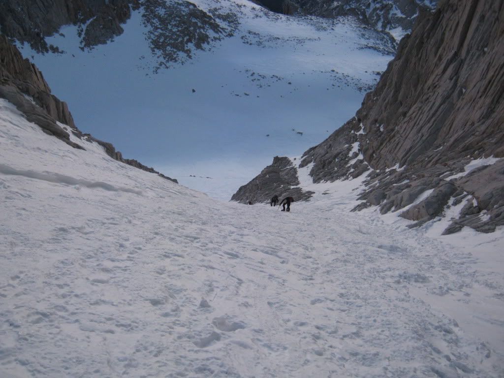 [/img]


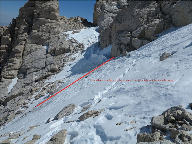


 top of the hill above Upper Boy Scout