|
|
#106215 - 05/18/24 12:14 PM
 Re: 2024
[Re: Richard P.]
Re: 2024
[Re: Richard P.]
|

Member
Registered: 05/16/24
Posts: 3
Loc: Maryland, USA
|
Hi everyone, I'm new to the forum. I'm heading to Whitney from Cottonwood Meadows with a friend (multi day trip): we start on Tuesday 5/21/24. We will be going via Rock Creek and up the Dreaded Sandhill. Has anyone been here recently? What are the snow conditions like from Cottonwood Pass to Crabtree Pass? A recent picture would be great! I'm just wondering if I need to bring snowshoes or just micro spikes...
Thanks!
|
|
Top
|
|
|
|
|
#106217 - 05/18/24 04:06 PM
Re: 2024
[Re: Patrick R.]
|
Member
Registered: 06/26/03
Posts: 5291
Loc: Ridgecrest, CA
|
http://www.mountwhitneyforum.com/ubbthreads.php?ubb=showflat&Number=106207#Post106207I stated in another thread...there is a good track (essentially) following the PCT...(Ranting: Unlike the Whitney area, the PCT'ers are smart enough to know that if everyone uses the same track, everybody wins with the savings in effort.) I'd say the melt level in the Forests is about 10,500. Heading up to Cottonwood Pass, there are a LOT of snow patches you'll have to cross if you try to stay with the Trail. You can "straight-line" it up on dirt/rock if you're willing to work the steeper terrain that cutting Switchbacks requires. (Coming down, I bobbed and weaved, and probably was on snow for a couple hundred steps (The hike was over 23k steps.) I did have to use my hands in a few places.) I just looked NoBo from Cottonwood Pass...it looked to me that it was going to be more of the same... Fatigue has prevented me from getting up towards Discovery Pinnacle to get the photo looking down the Sand Hill that I know many are interested in...(Maybe Monday??? So check the board.)
|
|
Top
|
|
|
|
|
#106220 - 05/19/24 04:43 PM
Re: 2024
[Re: Doug Sr]
|
Member
Registered: 05/16/24
Posts: 3
Loc: Maryland, USA
|
Thanks Doug and Richard!
Based on Richard's pictures, Cottonwood pass is looking good, so we're just going to try up Rock Creek and through Crabtree Pass. If we have to turn back, so be it!
I'll definitely post some pics once I'm back home at the end of May but I'll try and post an update before that.
|
|
Top
|
|
|
|
|
#106222 - 05/20/24 09:15 AM
Re: 2024
[Re: Socks N Crocs]
|
Member
Registered: 12/23/02
Posts: 595
Loc: Santa Clarita, CA
|
Excellent pictures!!! They really tell the story of how much snow is left.
Question: Was there snow in the boulder field before Gilbert? Ice?
thanks for sharing
paul
|
|
Top
|
|
|
|
|
#106223 - 05/20/24 09:24 AM
Re: 2024
[Re: Richard P.]
|
Member
Registered: 06/26/03
Posts: 5291
Loc: Ridgecrest, CA
|
Fatigue has prevented me from getting up towards Discovery Pinnacle to get the photo looking down the Sand Hill that I know many are interested in...(Maybe Monday??? So check the board.)
Crashed the lil 150 twice yesterday...wondering whether it's a coincidence that the desert sand turns to (deep, dry) crap at about the same time as the Sierra Snow turns to (deep, wet) crap... Anyway, my left butt cheek hurts enough that a climb of Whitney wouldn't have been safe, so I'm not up there...Sorry for no photos...
|
|
Top
|
|
|
|
|
#106225 - 05/20/24 11:48 AM
Re: 2024
[Re: Doug Sr]
|

Member
Registered: 05/17/24
Posts: 8
Loc: Los Angeles Ca
|
Hi Everyone heading up on the 28th. Any info on the switchbacks above trail camp. Are they passable or is it still the chute? Thanks
|
|
Top
|
|
|
|
|
#106227 - 05/20/24 01:45 PM
Re: 2024
[Re: Socks N Crocs]
|
Member
Registered: 05/17/24
Posts: 8
Loc: Los Angeles Ca
|
Thanks for info have a great day
|
|
Top
|
|
|
|
|
#106228 - 05/20/24 03:51 PM
Re: 2024
[Re: wannabe hiker]
|
Member
Registered: 06/26/03
Posts: 5291
Loc: Ridgecrest, CA
|
Paul and Socks are talking about Gilbert Lake out of Onion Valley...not The Switchbacks.
|
|
Top
|
|
|
|
|
#106230 - 05/21/24 04:49 AM
Re: 2024
[Re: Richard P.]
|
Member
Registered: 04/26/24
Posts: 5
Loc: Chicago
|
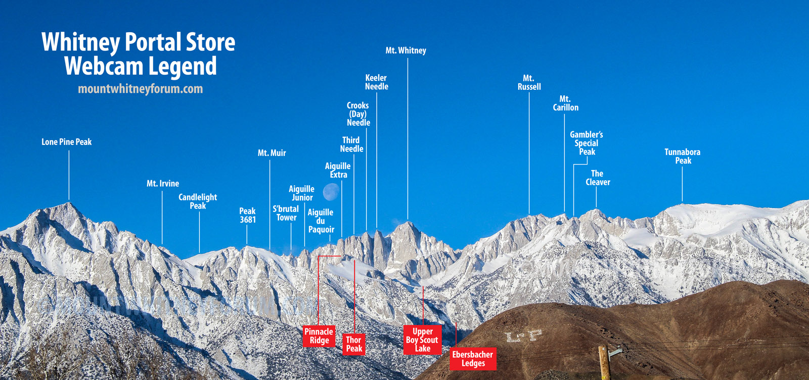
Is there a webcam shows the snow on the switchbacks? I thought left side of the image from Webcam#1/2 was the switchbacks but I am not sure. TIA!
|
|
Top
|
|
|
|
|
#106231 - 05/21/24 07:49 AM
Re: 2024
[Re: RunningKoi]
|
Member
Registered: 05/17/24
Posts: 8
Loc: Los Angeles Ca
|
Morning I think if you look mid screen to the right that's Witney, Its the highest point. I don't think you can see the switchbacks from the cams. Somebody please correct me if I'm wrong. I'm also looking for some current info on the 97 switchbacks as heading up next week.
|
|
Top
|
|
|
|
|
#106233 - 05/21/24 02:57 PM
Re: 2024
[Re: wannabe hiker]
|
Member
Registered: 06/05/07
Posts: 250
Loc: Aptos, California, USA
|
Correct, the switchbacks are not visible in the webcam images. Really, none of the Main Trail is visible, although much of the Mountaineer's Route is.
_________________________
climbSTRONG
"Avoiding danger is no safer in the long run than outright exposure. Life is either a daring adventure or nothing" -Helen Keller
|
|
Top
|
|
|
|
|
#106236 - 05/22/24 08:20 AM
Re: 2024
[Re: ClimbSTRONG]
|
Member
Registered: 05/20/24
Posts: 1
Loc: Nevada. USA
|
This may be a bit of a silly question but is a ski descent still possible on the Mountaineer's Route? I have a June 2nd permit and was planning on hoofing up the North Fork with skis on my back. About what altitude or landmark does continuous snow begin?
It has been about 15 years since my last summit of Whitney (hiking) and have been dreaming about coming back with skis!
|
|
Top
|
|
|
|
|
#106242 - 05/22/24 07:58 PM
Re: 2024
[Re: Doug Sr]
|

Member
Registered: 12/16/02
Posts: 2975
Loc: Whitney
|
Word several weeks ago great 100' of ski , some still going but melting fast above iceberg starting to show rock ,check webcam zoom into the north fork and you will see the current conditions daily . For got to mention Upper Gate Horseshoe Meadows opened today,area now has a camp host and I assume will collect fees for camping.
|
|
Top
|
|
|
|
|
#106244 - 05/23/24 05:05 AM
Re: 2024
[Re: Jeff M]
|
Member
Registered: 05/22/24
Posts: 3
Loc: Henrico, VA
|
Good morning! Can anyone tell me the exact weather and trail conditions for 06/17/24 and 06/18/24? Thanks in advance!
Short of that I do need advice on footwear. I have an east coast brain and east coast trail runners. When I put in my permit dates I was only thinking about my calendar and how hot my training would be in the spring Appalachian jungle and not mother nature in the Sierras. Now I'm 3 weeks out and worried about my tootsies and slip sliding.
I have low top, non-waterproof trail runners and planned to get micro spikes.
Should I buy high top "waterproof" trail runners / light hikers?
What are the chances I'll need stiff boots and ... crampons?! Suggestions on brands / models that I can break in fast like?
Does anyone know of a shop between LAX and Lone Pine that RENTS BOOTS?
I apologize for not asking this question two months ago.
|
|
Top
|
|
|
|
|
#106245 - 05/23/24 12:24 PM
Re: 2024
[Re: Mr. B]
|
Member
Registered: 06/26/03
Posts: 5291
Loc: Ridgecrest, CA
|
The melt won't be complete by then...so ice early and wet track late...or maybe a wet track all day... The thought that kept popping into my head yesterday at Horseshoe Meadows (high 9's to 11.2k) was: water shoes or (real) waterproofs...trail runners would be a soggy mess...no thanks... I was wearing these: https://www.eddiebauer.com/p/91903388Bought them on a whim with a big discount and coupon...they are surprisingly comfortable in all the weather conditions I've used them...they work OK with crampons (less stiff than I would really prefer), but you probably won't be needing them...micros, definitely...and are real waterproofs...I only avoid deep looking puddles with these on...and not having to break stride to look for a dry step makes a big difference at The End Of The Day...
|
|
Top
|
|
|
|
|
|


 Previous Topic
 Index
Index